Fire scene positioning method and system based on unmanned aerial vehicle

A positioning method and UAV technology are applied in the field of UAV-based fire field positioning methods and systems to achieve the effects of easy job layout, fast and precise positioning, and high positioning accuracy

Active Publication Date: 2018-12-07
JINAN UNIVERSITY +2
View PDF14 Cites 1 Cited by
  • Summary
  • Abstract
  • Description
  • Claims
  • Application Information

AI Technical Summary

Problems solved by technology

When a fire breaks out, the most important thing is to accurately locate the situation on the spot, and how to increase the speed, how to simplify the operation process, how to reduce the cost of equipment, and how to achieve visual on-site reconstruction are the corresponding technologies while satisfying the accuracy. challenge

Method used


Image

  • Fire scene positioning method and system based on unmanned aerial vehicle
  • Fire scene positioning method and system based on unmanned aerial vehicle
  • Fire scene positioning method and system based on unmanned aerial vehicle

Examples


Embodiment Construction

[0044] The technical solutions in the embodiments of the present invention will be clearly and completely described below in conjunction with the accompanying drawings in the embodiments of the present invention. Obviously, the described embodiments are only some of the embodiments of the present invention, not all of them. Based on the embodiments of the present invention, all other embodiments obtained by persons of ordinary skill in the art without creative efforts fall within the protection scope of the present invention.

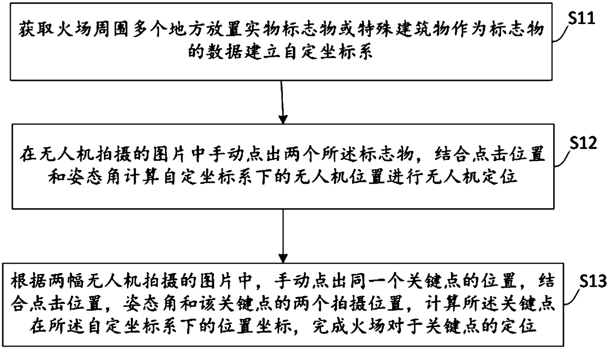
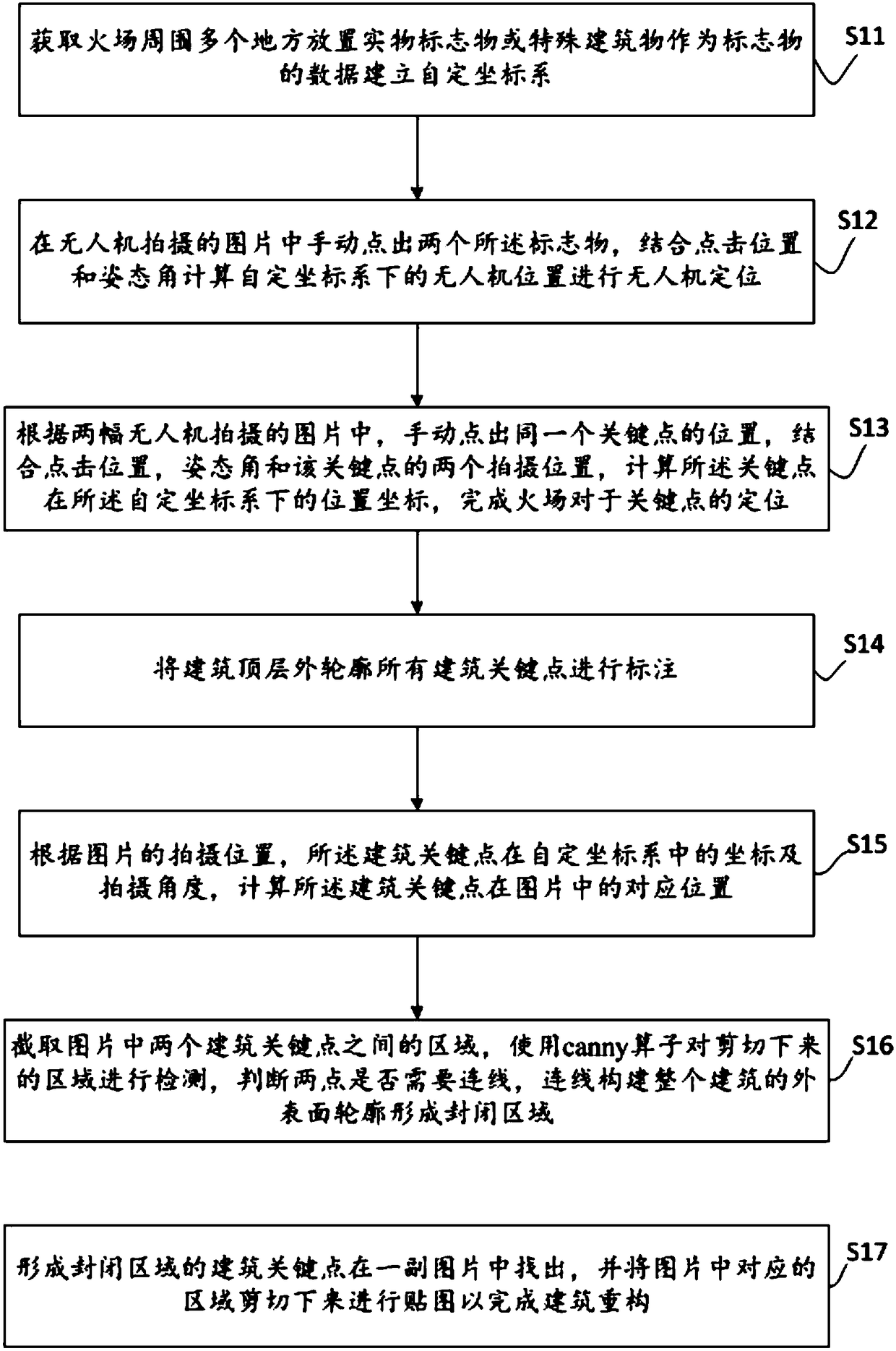
[0045] see figure 1 , is a schematic flowchart of a UAV-based fire location method according to Embodiment 1 of the present invention. The method includes steps as follows:

[0046] Step S11: Obtain the data of placing physical markers or special buildings as markers in multiple places around the fire scene to establish a self-defined coordinate system.

[0047] Specifically, when a fire occurs, disaster relief personnel evacuate the scene and conduct...


PUM


Abstract

The invention discloses a fire scene positioning method and system based on an unmanned aerial vehicle. The method comprises the following steps: acquiring data of physical object markers or special buildings arranged in multiple places around the fire scene to serve as markers, and establishing a self-determining coordinate system; manually pointing out two of the markers from pictures shot by the unmanned aerial vehicle, combining the click positions and an attitude angle to calculate the position of the unmanned aerial vehicle under the self-determining coordinate system so as to perform unmanned aerial vehicle positioning; manually pointing out the position of the same key point according to the two pictures shot by the unmanned aerial vehicle, combining the click position, the attitude angle and two shooting positions of the key point, calculating the position coordinate of the key point in the self-determining coordinate system, and completing positioning of the fire scene relative to the key point, wherein the position of the unmanned aerial vehicle is the shooting position. According to the method disclosed by the invention, the fire scene is accurately and rapidly positioned, the key point and buildings are marked, intuitive site conditions are provided for fire scene commanders, the fire scene commanders are assisted in making disaster relief tactic decisions, and theefficiency is greatly improved.

Description

technical field [0001] The present invention relates to the technical field of unmanned aerial vehicles and fire detection, in particular to a method and system for locating fire sites based on unmanned aerial vehicles. Background technique [0002] As the saying goes: "Water and fire are merciless", the handling of fire is still a worldwide problem today. [0003] Fires are sporadic, frequent, and sudden, and the fire is easy to spread. When a fire occurs, firefighters need to investigate the fire scene as soon as possible, determine the fire situation, conduct tactical deployment for the on-site building structure, and look for rescue targets and rescue routes. Only when the fire commander has a comprehensive and detailed understanding of the fire situation in a timely manner can he make correct judgments and deployments to achieve the purpose of controlling the spread of the fire and reducing economic losses and casualties. [0004] At present, the method of fire invest...

Claims


Application Information

Patent Timeline
Patent Type & Authority Applications(China)
IPC IPC(8): G01C11/04G01S19/14
CPCG01C11/04G01S19/14
Inventor 郭江凌路博超许自然廖春生丁文倩吴振恒许春宇
Owner JINAN UNIVERSITY
Why Eureka
Try Eureka