A scene fusion visualization method based on multiple geographic information platforms

A geographic information and scene technology, applied in electrical digital data processing, special data processing applications, instruments, etc., can solve the problems of low cost performance of complete 3D GIS, single geographic scene and data visualization form, etc., to improve the visualization level and expand the scene. Demonstrating capabilities and reducing development costs

Inactive Publication Date: 2018-12-07
中国科学院电子学研究所苏州研究院
View PDF0 Cites 1 Cited by
  • Summary
  • Abstract
  • Description
  • Claims
  • Application Information

AI Technical Summary

Problems solved by technology

[0006] These issues include: 1. The single issue of the geographic scene and data visualization form of the WebGIS platform
3. Low cost performance of full 3D GIS development

Method used


Image

  • A scene fusion visualization method based on multiple geographic information platforms
  • A scene fusion visualization method based on multiple geographic information platforms
  • A scene fusion visualization method based on multiple geographic information platforms

Examples


Embodiment Construction

[0046] Below in conjunction with accompanying drawing, technical scheme of the present invention is described in further detail:

[0047] Those skilled in the art can understand that, unless otherwise defined, all terms (including technical terms and scientific terms) used herein have the same meaning as commonly understood by those of ordinary skill in the art to which this invention belongs. It should also be understood that terms such as those defined in commonly used dictionaries should be understood to have a meaning consistent with the meaning in the context of the prior art, and will not be interpreted in an idealized or overly formal sense unless defined as herein Explanation.

[0048] first part:

[0049] The present invention will be further described in detail below in conjunction with the accompanying drawings and specific embodiments.

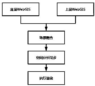
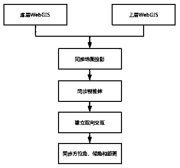
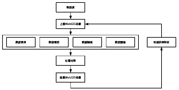
[0050] figure 1 It is a mechanism block diagram of the method of the present invention, and a scene fusion visualization metho...


PUM


Abstract

The invention discloses a scene fusion visualization method based on multiple geographic information platforms, the method comprising the following steps in detail: the upper scene and the lower sceneare fused and synchronized; the upper scene and the lower scene are fused and synchronized; connections are established to maintain the consistency of spatial analysis between the upper scenario andthe lower scenario; the scene is rendered by judging mechanism. The invention provides a scene fusion method based on multiple geographic information platforms to realize the fusion of scenes under aplurality of dimensions and platforms through a unified standard to achieve synchronous rendering and synchronous operation. The invention combines the single geographic scene with the digital earth,endows the spatial coordinate attribute of the geographic scene and improves the visualization level of the digital earth, realizes the diversification of the earth big data elements, and avoids the dependence of the WebGIS platform on the single geographic scene. Different scenarios can interact with each other to achieve the consistency of data representation and spatial analysis.

Description

technical field [0001] The invention belongs to the field of geographic information visualization and relates to a scene fusion visualization method under multiple geographic information platforms. Background technique [0002] With the explosive development of the Internet, WebGIS technology perfects and expands the traditional GIS technology, and provides opportunities for many users to use GIS. WebGIS technology has good scalability and cross-platform. In the Internet environment, WebGIS can realize the sharing of spatial data information among various fields and departments in the whole society, and greatly improve the efficiency of querying, publishing and maintaining spatial information. [0003] With the development of scripting languages ​​such as WebGL technology and JavaScript, people's demand for the visualization level of geographic big data is increasing. Excellent 2.5D and 2D GIS platforms such as Echarts, DeckGL, and Mapbox and some open source databases have...

Claims


Application Information

Patent Timeline
IPC IPC(8): G06F17/30
Inventor 徐汇军顾爽赵爽钱晶付啟明张尧
Owner 中国科学院电子学研究所苏州研究院
Why Eureka
Try Eureka