

A rice yield estimation method integrated with remote sensing and meteorology
A rice and meteorological technology, applied in the field of agricultural remote sensing, can solve the problems of data interpretation process error, remote sensing data error, insufficient to meet the application needs of high-precision crop yield estimation, etc., to achieve the effect of enhancing accuracy and improving the level of standardization
- Summary
- Abstract
- Description
- Claims
- Application Information
AI Technical Summary
Problems solved by technology
Method used
Image

Examples
Embodiment Construction
[0028] 以下,基于附图针对本发明进行详细地说明。
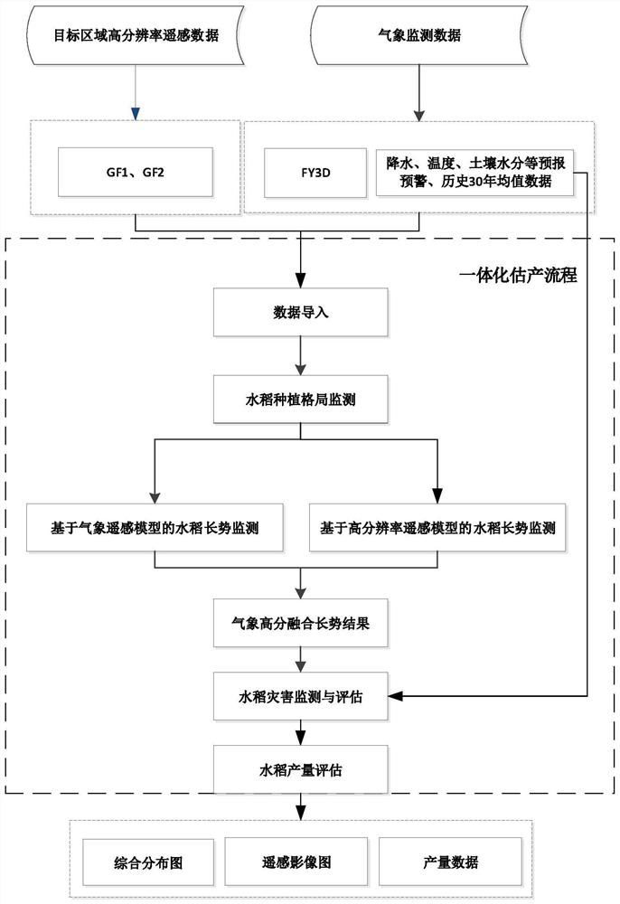
[0029] Such as figure 1 所示,本发明设计了一种遥感及气象一体化水稻估产方法,考虑水稻遥感估产的适应性以及估产的精度,方法的建立和提高体现在以下二个方面:(1)基于气象监测数据和高分辨率卫星遥感影像数据一体化监测手段,构建水稻估产模型,提升水稻和玉米的估产精度;(2)形成遥感气象一体化农作物估产过程,充分提高遥感农作物估产作业标准化水平,增强遥感农作物估产结果的准确性。具体地,本发明方法包括以下步骤:
[0030] 步骤1、输入目标区域内农作物种植的遥感影像数据。
[0031] 输入目标区域内的遥感影像数据,本方法输入的是GF1、GF2进行几何校正后的数据,以及FY3D MERSI-2反演的植被指数产品,作为目标区域水稻遥感信息提取待处理数据。
[0032] 步骤2、根据不同地物及各农作物之间的光谱特征差异,利用GF1、GF2数据,利用最大似然监督分类算法快速、准确获取所需区域的农作物种植分类信息。
[0033] 所述最大似然监督分类算法,实现对大范围遥感影像数据进行监督分类,并输出类别标号影像的算法。算法包含最大似然监督分类和投票滤波后处理两大部分,其中最大似然监督分类还包含分类器训练和分类决策两个小部分。
[0034] 其中,最大似然监督分类算法分类过程具体如下:
[0035] (1)对分类器训练:对遥感影像数据中已知物种类别信息的样本进行统计分析,获得各个类别对应的特征的条件概率分布,并以该条件概率分布和类别的先验概率作为分类的 in accordance with;
[0036] (2)分类决策:最大似然分类决策是对位置类别的特征进行归类的过程。主要通过计算遥感影像数据内所需区域中物种特征对于各个类别的后验概率完成,并将计算的最大后验概率的类别确定为物种特征所归属的类别。
[0037] 所述投票滤波后处理过程具体如下:
[0038] 投票滤波处理是一种常用的分类后处理方法,主要对获得的农作物种植分类信息投票滤波,用于去除分类后类别图像中的孤立点,平滑分类图像。
[0039] 步骤3、基于农作物分类结果,根据农作物种植分类信息分类别统计像元个数的多少,及根据遥感影像数据中固定传感器的空间分辨率计算单个像元面...
PUM
 Abstract
Description
Claims
Application Information