A CNN-LSTM-based method for crop yield estimation at the county level

A crop and county-level technology, applied in the field of CNN-LSTM-based crop yield estimation at the county level, can solve problems such as little attention to yield prediction, and achieve the effect of improving the accuracy of yield estimation

Active Publication Date: 2022-04-01
CHINA UNIV OF GEOSCIENCES (WUHAN)
View PDF3 Cites 0 Cited by
  • Summary
  • Abstract
  • Description
  • Claims
  • Application Information

AI Technical Summary

Problems solved by technology

Researchers generally believe that CNN can explore more spatial features, and LSTM as a special RNN has the ability to reveal phenological features, however, little attention has been paid to combining the advantages of CNN and LSTM for yield prediction

Method used


Image

  • A CNN-LSTM-based method for crop yield estimation at the county level
  • A CNN-LSTM-based method for crop yield estimation at the county level
  • A CNN-LSTM-based method for crop yield estimation at the county level

Examples


Embodiment Construction

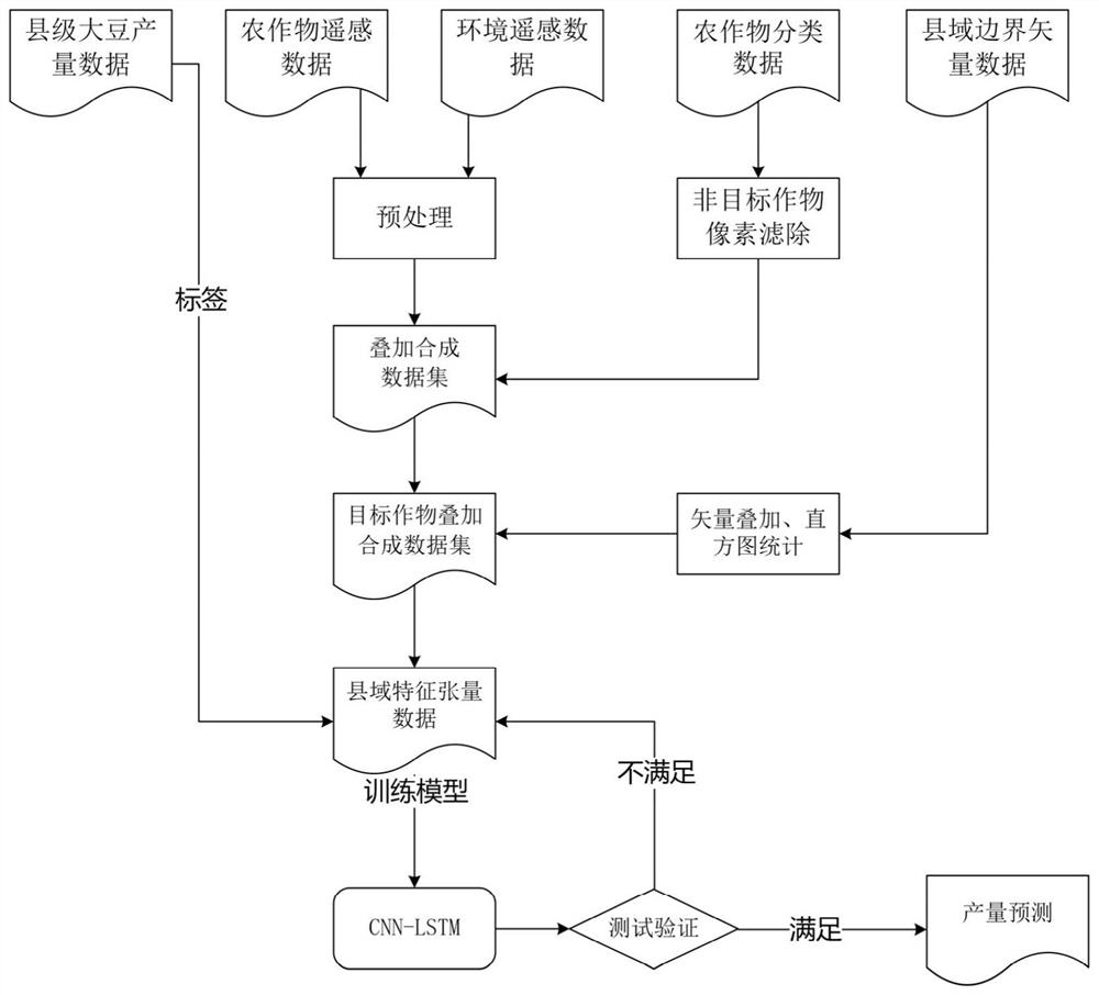
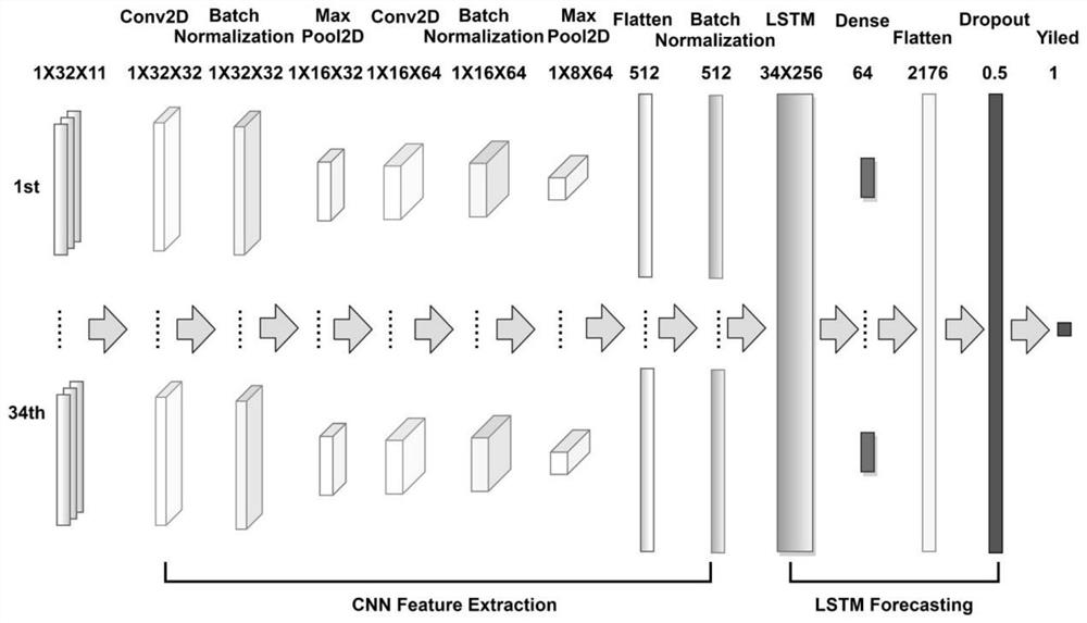
[0035] In order to make the purpose, technical solution and advantages of the present invention clearer, the embodiments of the present invention will be further described below in conjunction with the accompanying drawings.

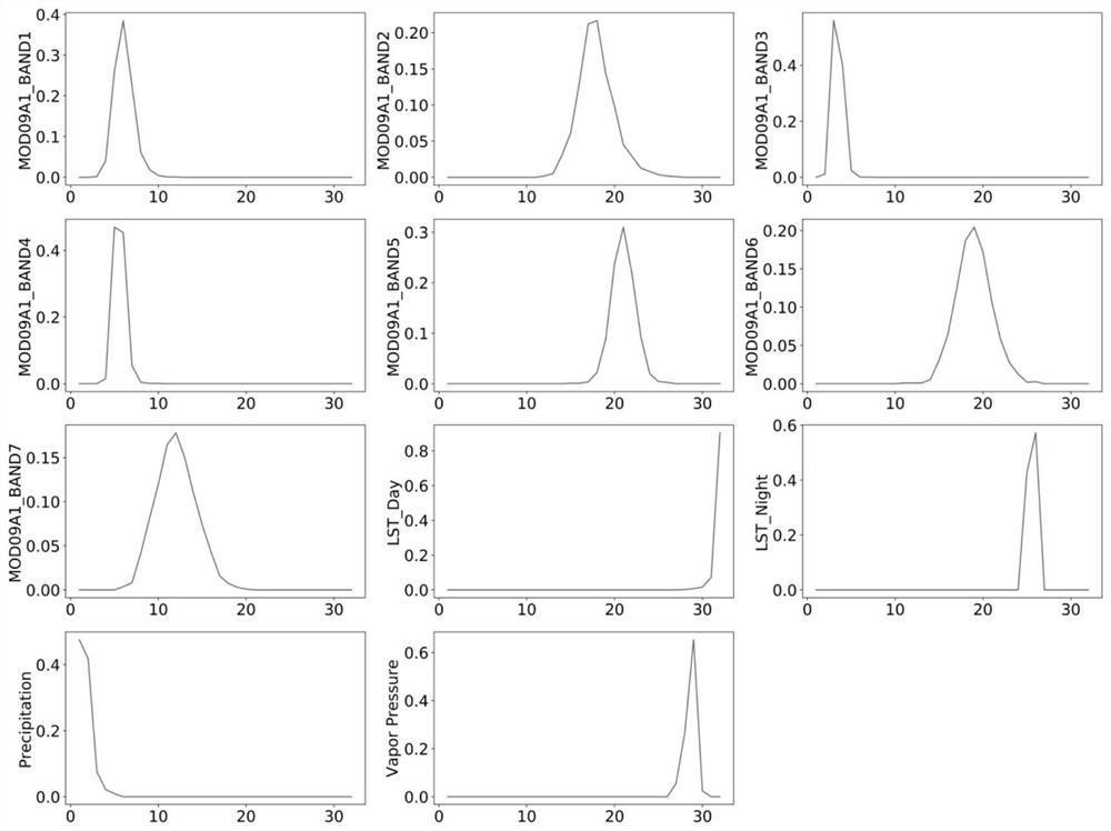
[0036]In the invention, the 15 states in the middle of the United States are taken as the case area, based on the remote sensing data and historical production data from 2003 to 2015 as the data source, the soybean production in the area from 2011 to 2015 is estimated, and the estimated results are compared with the real ones. Compare with official figures.

[0037] Selection of production areas to be estimated: According to the soybean planting distribution announced by the United States Department of Agriculture (USDA), soybeans are grown in 31 states. In this case, 15 states are selected as examples, including North Dakota, South Dakota, Nebraska California, Minnesota, Iowa, Kansas, Missouri, Arkansas, Mississippi, Tennessee, Illinois, Indiana, Ohio, ...


PUM


Abstract

The present invention relates to the technical field of remote sensing image information extraction, in particular to a method for estimating crop production at the county level based on CNN-LSTM, which includes the following steps: acquisition and processing of S1 data, superposition and filtering of S2 data, S3 acquisition of county Scale feature tensor data, S4 build and train CNN-LSTM model, S5 apply the CNN-LSTM model trained in S4 to estimate the yield of target crops. The method of the present invention is based on the remote sensing data reflecting the growth state of crops and the environmental data affecting the growth of crops, and extracts more features of county-level crops through the method of histogram statistics and converts them into tensors, so as to train the extracted CNN-LSTM model, Effectively improve the accuracy of small-scale crop yield estimation.

Description

technical field [0001] The invention relates to the technical field of remote sensing image information extraction, in particular to a CNN-LSTM-based crop yield estimation method at the county level. Background technique [0002] Crop yield is the most important indicator of agriculture and has many connections with human society. Yield forecasting is one of the most challenging tasks in precision agriculture and has important implications for yield mapping, crop market planning, crop insurance, and harvest management. [0003] Remote sensing technology has been widely used in crop yield estimation. Various relevant information can be extracted from remote sensing data to assist production estimation. In particular, various vegetation indices (VI), such as the normalized difference vegetation index (NDVI), have been widely used. Other indices such as Green Leaf Area Index (GLAI), Crop Water Stress Index (CWSI), Normalized Difference Water Index (NDWI), Green Vegetation In...

Claims


Application Information

Patent Timeline
Patent Type & Authority Patents(China)
IPC IPC(8): G06Q10/06G06Q10/04G06Q50/02G06N3/08G06N3/04G01N21/17
CPCG06Q10/06393G06N3/08G06Q10/04G06Q50/02G01N21/17G01N2021/1797G01N2021/178G01N2021/1765G06N3/044G06N3/045
Inventor 孙杰赖祖龙陈性义余俊杰
Owner CHINA UNIV OF GEOSCIENCES (WUHAN)
Why Eureka
Try Eureka