Method and system for autonomous landing of UAV based on photoelectric-inertial combined guidance

A technology of inertial combination and photoelectric tracking system, applied in control/adjustment system, navigation, surveying and mapping and navigation, etc., can solve problems such as difficult to play a guiding role, and achieve the effect of maintaining long-term pose accuracy

Active Publication Date: 2020-06-26
XI'AN INST OF OPTICS & FINE MECHANICS - CHINESE ACAD OF SCI +1
View PDF10 Cites 2 Cited by
  • Summary
  • Abstract
  • Description
  • Claims
  • Application Information

AI Technical Summary

Problems solved by technology

At present, there is also a visual navigation-inertial integrated navigation system, but it is difficult to play a guiding role when the UAV is far away from the ship

Method used


Image

  • Method and system for autonomous landing of UAV based on photoelectric-inertial combined guidance
  • Method and system for autonomous landing of UAV based on photoelectric-inertial combined guidance
  • Method and system for autonomous landing of UAV based on photoelectric-inertial combined guidance

Examples


Embodiment Construction

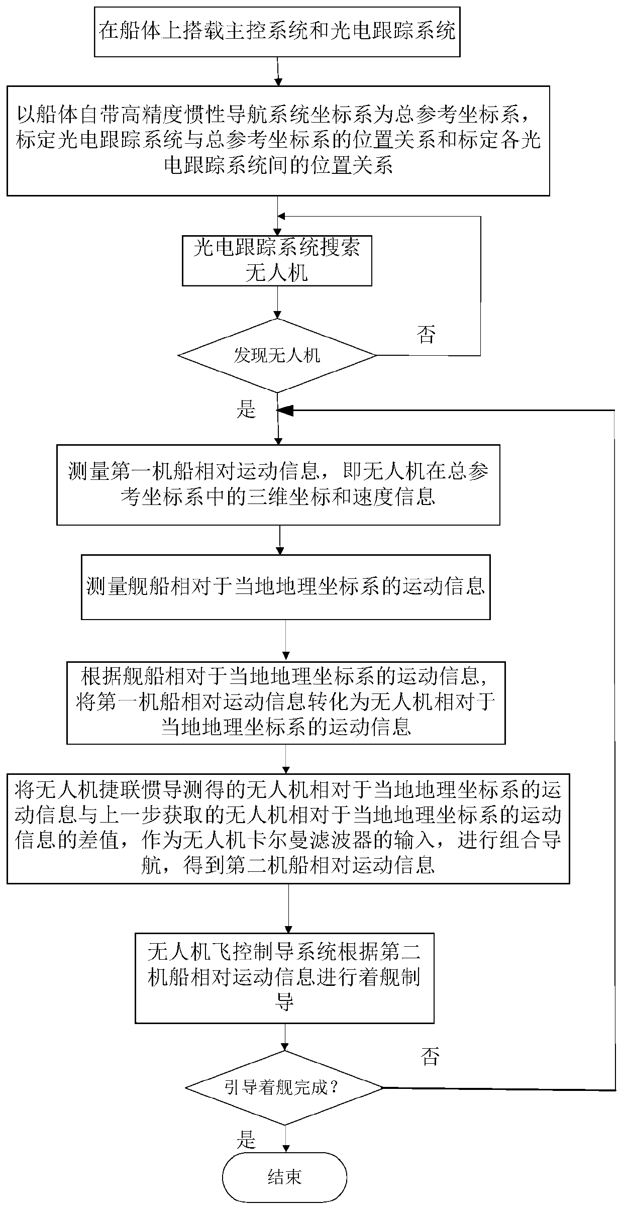
[0053] The present invention will be further described below in conjunction with the drawings.

[0054] See figure 1 , Picture 10 , The autonomous landing method for drones provided by the present invention includes the following steps:

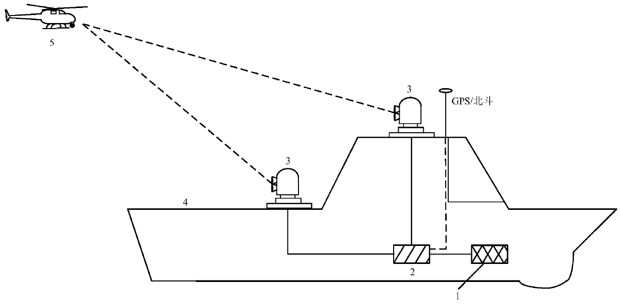
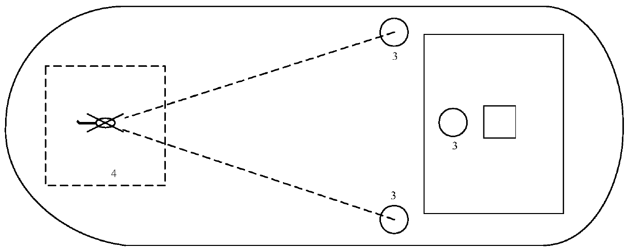
[0055] 1) Build the system:

[0056] The main control system and at least one photoelectric tracking system are set on the hull of the ship. The photoelectric tracking system includes a photoelectric platform. The photoelectric platform is equipped with an optical system and a photoelectric platform strapdown inertial navigation system for providing posture information of the photoelectric platform. Optical system includes camera and laser rangefinder;

[0057] 2) Calibration:

[0058] Using the coordinate system of the ship's own inertial navigation system as the total reference coordinate system, calibrate the relative position relationship between each photoelectric tracking system and the total reference coordinate system, and calibrate the relat...


PUM


Abstract

In order to overcome defects existing in the existing unmanned aerial vehicle autonomous ship landing technology, the invention provides an unmanned aerial vehicle autonomous ship landing method and system based on photoelectric-inertial combined guidance. According to the method, a coordinate system of a hull-carried inertial navigation system is used as a global reference coordinate system (benchmark), the position and velocity of an unmanned aerial vehicle relative to a hull are acquired through photoelectric tracking systems on the hull, the position and velocity of a ship relative to a local geographic coordinate system are acquired through the hull-carried inertial navigation system, the position and velocity of the unmanned aerial vehicle relative to the local geographic coordinatesystem are obtained through unmanned aerial vehicle strapdown inertial navigation measurement, and the position and velocity information is transmitted to an unmanned aerial vehicle Kalman filter forcombined navigation. In this way, regardless of a satellite signal outside, the unmanned aerial vehicle can perform photoelectric-INS combined navigation, so that the unmanned aerial vehicle gets ridof dependence on an external GPS or Beidou signal in the ship landing process.

Description

Technical field [0001] The invention belongs to the technical field of target tracking measurement and navigation positioning, and relates to an autonomous landing method and system that uses an inertial navigation system and a photoelectric tracking system for UAV guidance. Background technique [0002] Autonomous landing of UAVs refers to the process in which UAVs rely on onboard navigation equipment and flight control systems for positioning and navigation and ultimately controlling the UAV to land on the deck. To achieve autonomous landing of UAVs, UAVs must have autonomous navigation capabilities. Therefore, high-precision autonomous navigation technology is the key technology for autonomous UAV landings. At present, the navigation technologies for autonomous UAV landing at home and abroad include: inertial navigation system (INS), GPS navigation, INS-GPS integrated navigation system and visual navigation system. Among them, the inertial navigation system is the earliest an...

Claims


Application Information

Patent Timeline
Patent Type & Authority Patents(China)
IPC IPC(8): G05D1/06G01C21/20G01C21/16
CPCG01C21/165G01C21/20G05D1/0676
Inventor 林俤于芳苏吴易明朱帆魏轶婷
Owner XI'AN INST OF OPTICS & FINE MECHANICS - CHINESE ACAD OF SCI
Why Eureka
Try Eureka