
An intelligent navigation algorithm based on real-time road conditions

A technology of intelligent navigation and real-time road conditions, applied in the field of vehicle navigation, can solve the problems of gathering a large number of vehicles, road congestion, and increased calculation time of navigation algorithms, so as to achieve the effect of ensuring and accelerating the convergence speed

Active Publication Date: 2022-07-12
GUANGDONG UNIV OF TECH
View PDF7 Cites 0 Cited by
  • Summary
  • Abstract
  • Description
  • Claims
  • Application Information

AI Technical Summary

Problems solved by technology

The existing navigation algorithms have the disadvantages of a sharp increase in calculation time with the increase of the road network, the navigation route ignores real-time conditions, and does not consider road congestion, etc., and it is easy to gather a large number of vehicles on certain road sections, resulting in unbalanced traffic flow distribution and road congestion.

Method used


Image

  • An intelligent navigation algorithm based on real-time road conditions
  • An intelligent navigation algorithm based on real-time road conditions
  • An intelligent navigation algorithm based on real-time road conditions

Examples


Embodiment 1

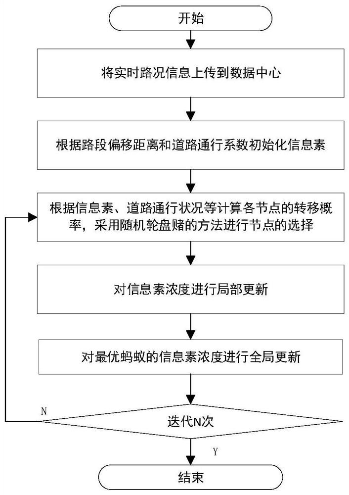
[0045] An intelligent navigation algorithm based on real-time traffic conditions, please refer to figure 1 , including the following steps:

[0046] S1: Upload the road condition information of the traffic network to the data center, which includes the length of the road section, the number of vehicles, and the number of lanes, and estimate the traffic flow and road smoothness coefficient according to the above information:

[0047] ω ij =Q ij / (d ij *n ij ) (1)

[0048] In the above formula (1), ω ij is the traffic flow, Q ij is the number of vehicles on the road segment ij, d ij is the length of the road segment, n ij is the number of lanes;

[0049]

[0050] In formula (2), μij is the road smoothness coefficient of road segment ij, μ ij ∈ [0, 1], which is related to the traffic flow ω ij related, when ω ij When it is very large, the road smoothness coefficient tends to 0; otherwise, the road smoothness coefficient tends to 1;

[0051] S2: Initialization info...


PUM


Abstract

The invention discloses an intelligent navigation algorithm based on real-time road conditions. The invention applies the ant colony algorithm to the field of car navigation, takes the traffic flow factor into consideration, and takes the traffic flow as a parameter affecting the ant colony pheromone, so that the vehicle can try to Select the road section with short distance and smooth traffic to achieve the goal of avoiding congested road sections and balancing traffic flow on the road network. In addition, when the number of road network nodes increases, the ant colony algorithm has slow convergence speed and is easy to fall into local shortcomings. Dynamic adjustment and the introduction of the idea of ​​elite ants greatly improve the performance of the algorithm.

Description

technical field [0001] The invention relates to the field of vehicle navigation, and more particularly, to an intelligent navigation algorithm based on real-time road conditions. Background technique [0002] With the development of economy and the improvement of people's living standards, the number of vehicles on urban roads has increased dramatically, which has greatly promoted the development of the vehicle navigation industry. Most of the traditional navigation products are based on the pre-stored maps, based on the idea of ​​graph theory, using Dijkstra's algorithm, A* algorithm and other algorithms to obtain the shortest path. Existing navigation algorithms have shortcomings such as sharp increase in calculation time with the increase of road network, ignoring real-time conditions of navigation routes, and ignoring road congestion. [0003] When dealing with large-scale complex dynamic environment path planning problems, intelligent optimization algorithms often have...

Claims


Application Information

Patent Timeline
Patent Type & Authority Patents(China)
IPC IPC(8): G01C21/34
CPCG01C21/3492Y02T10/40
Inventor 曾志伟曾碧曾育林
Owner GUANGDONG UNIV OF TECH
Learn More