
An electronic sand table system based on BIM + GIS and a construction method thereof

An electronic sand table and construction method technology, applied in the field of digital management, can solve the problem of less application of electronic sand table management functions, and achieve the effect of simple sharing and collaboration, easy to use, and improved pertinence

Inactive Publication Date: 2019-01-15
GUANGXI ROAD & BRIDGE ENG GRP CO LTD
View PDF8 Cites 17 Cited by
  • Summary
  • Abstract
  • Description
  • Claims
  • Application Information

AI Technical Summary

Problems solved by technology

In engineering construction projects, the application of electronic sand table is becoming more and more extensive, but at this stage, the combination of electronic sand table and actual terrain and the display of refined models are still in the preliminary exploration stage. At the same time, the application of management functions of electronic sand table besides display still less

Method used


Image

  • An electronic sand table system based on BIM + GIS and a construction method thereof

Examples


Embodiment Construction

[0033] The present invention will be further described below in conjunction with the accompanying drawings and embodiments. It should be noted that the specific embodiments of the present invention are only for the purpose of describing the technical solution more clearly, but not as a limitation of the protection scope of the present invention.

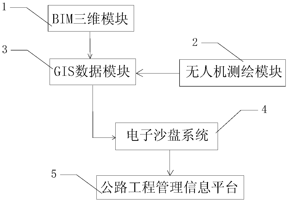
[0034] see figure 1 , an electronic sand table system 4 based on BIM+GIS, including BIM three-dimensional module 1, UAV surveying and mapping module 2, GIS data module 3, electronic sand table system 4 and highway engineering management information platform 5; BIM three-dimensional module 1 and unmanned The computer surveying and mapping module 2 is connected with the GIS data module 3 respectively, and the GIS data module 3 and the highway engineering management information platform 5 are respectively connected with the electronic sand table system 4;

[0035] BIM three-dimensional module 1 is used to establish a visualized BIM mod...


PUM


Abstract

The invention belongs to the technical field of digital management. The invention relates to an electronic sand table system based on BIM + GIS, which comprises a BIM three-dimensional module, an unmanned aerial vehicle surveying and mapping module, a GIS data module and an electronic sand table system. BIM three-dimensional module is used to establish visual BIM model according to two-dimensionaldesign drawings. The unmanned aerial vehicle (UAV) surveying and mapping module is used for acquiring 3D terrain data of construction area and image data of construction stage. GIS data module is usefor storing GIS data. The electronic sand table system is used to establish the electronic sand table based on the BIM model, the three-dimensional terrain data of the construction area, the image data of the construction stage and the GIS data. Highway engineering management information platform is used to generate the operation interface of electronic sand table based on 3D GIS. The invention is used for realizing the visualization display of the whole landform of the construction area in the three-dimensional geographic information space from the global angle, and has the characteristics of digitalization, visualization and intelligence.

Description

technical field [0001] The invention belongs to the technical field of digital management, and in particular relates to a BIM+GIS-based electronic sand table system and a construction method. Background technique [0002] With the development of the times and the advancement of science and technology, people's ideas and appreciation levels have also been greatly improved. The three-dimensional, interactive and diversified display forms of the electronic sand table make the electronic sand table the darling of project display. The traditional two-dimensional display mode and three-dimensional static model mode are upgraded to three-dimensional dynamic digital virtual mode, which brings people a brand-new interactive experience in terms of visual appreciation and three-dimensional lifelike presentation. In engineering construction projects, the application of electronic sand table is becoming more and more extensive, but at this stage, the combination of electronic sand table ...

Claims


Application Information

Patent Timeline
IPC IPC(8): G09B25/00G06Q50/08G06Q10/10G06F17/50G06F16/909
CPCG06Q10/103G06Q50/08G09B25/00G06F30/13
Inventor 孙辉王建军林广泰陈孝强李雍友陆进黄升黄文聪韦曼怡蔡孟龙孟金杨文达
Owner GUANGXI ROAD & BRIDGE ENG GRP CO LTD
Learn More