Eureka AIR delivers breakthrough ideas for toughest innovation challenges, trusted by R&D personnel around the world.

Underwater topography measurement device and method

A technology for underwater topography and measuring devices, which is applied in the directions of surveying devices, surveying and navigation, instruments, etc., can solve the problems of underwater topography measurement being affected by the environment and cannot be measured in time, and achieves the effect of solving safety and seasonal restrictions

Active Publication Date: 2019-01-25
四川中水成勘院测绘工程有限责任公司
View PDF10 Cites 4 Cited by
  • Summary
  • Abstract
  • Description
  • Claims
  • Application Information

AI Technical Summary

Problems solved by technology

[0007] In order to solve the above problems, the present invention proposes an underwater terrain measurement device and method, which solves the problem that the existing underwater terrain measurement cannot be measured in time due to the influence of the environment

Method used


Image

  • Underwater topography measurement device and method
  • Underwater topography measurement device and method
  • Underwater topography measurement device and method

Examples


Embodiment Construction

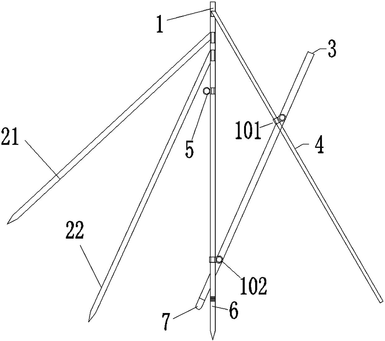
[0039] In order to make the purpose, technical solutions and advantages of the embodiments of the present invention clearer, the technical solutions in the embodiments of the present invention will be clearly and completely described below in conjunction with the drawings in the embodiments of the present invention. Obviously, the described embodiments It is a part of embodiments of the present invention, but not all embodiments. The components of the embodiments of the invention generally described and illustrated in the figures herein may be arranged and designed in a variety of different configurations.

[0040] Accordingly, the following detailed description of the embodiments of the invention provided in the accompanying drawings is not intended to limit the scope of the claimed invention, but merely represents selected embodiments of the invention. Based on the embodiments of the present invention, all other embodiments obtained by persons of ordinary skill in the art wi...


PUM


Abstract

The invention discloses an underwater topography measurement device and method. The device comprises a tripod, an energy converter, a slide rule rod and an energy converter connection rod. The tripodcomprises a centering rod, a first lifting rod and a second lifting rod, one end of the first lifting rod is movably connected with one end of the centering rod, and one end of the second lifting rodis movably connected with one end of the centering rod; one end of the slide rule rod is movably connected with one end of the centering rod, one end of the energy converter connection rod is rotatably connected with the slide rule rod through a first connection ring, the other end of the energy converter connection rod is rotatably connected with the other end of the centering rod through a second connection ring, and the energy converter is arranged at the bottom of the other end of the energy converter connection rod. According to the underwater topography measurement device and method, theslide rule rod controls the direction, and the energy converter connection rod controls a water inlet angle of a depth measurement signal to achieve the aim of mapping underwater topography; the underwater topography measurement work is moved from water to the shoreside, and the problems of safety and season limit of underwater topography measurement are effectively solved.

Description

technical field [0001] The invention relates to the technical field of terrain surveying, in particular to an underwater terrain surveying device and method. Background technique [0002] In order to meet the safety requirements of traditional underwater topographic survey, underwater topographic survey must be carried out in the dry season. At present, there are two commonly used methods for underwater topographic survey: [0003] 1. Fix the depth sounder on the ship, and drive the ship to the water area that needs to be surveyed to measure by the section method or the scatter method; [0004] 2. Steel rope cross-section method: set up a steel rope on the river surface at regular intervals in the area to be measured, and then place a weight on the steel rope at regular intervals to measure a water depth. [0005] The applicable scope of method 1 is the area with relatively gentle water flow, and the applicable scope of method 2 is that the width of the river surface is not...

Claims


Application Information

Patent Timeline
Patent Type & Authority Applications(China)
IPC IPC(8): G01C7/02
CPCG01C7/02
Inventor 陈尚云王渊饶兴贵刘非李旭
Owner 四川中水成勘院测绘工程有限责任公司
Why Eureka
Eureka Blog
Learn More