
A handheld navigation signal simulator

A navigation signal and simulator technology, applied in the field of satellite navigation signals, can solve the problems of inconvenient portability of navigation signal simulators, high requirements for use environment and conditions, etc., and achieve the effect of convenient and flexible use and control

Active Publication Date: 2020-12-15
NO 54 INST OF CHINA ELECTRONICS SCI & TECH GRP
View PDF9 Cites 0 Cited by
  • Summary
  • Abstract
  • Description
  • Claims
  • Application Information

AI Technical Summary

Problems solved by technology

However, the current navigation signal simulator is inconvenient to carry, or has relatively high requirements for the use environment and conditions

Method used


Image

  • A handheld navigation signal simulator
  • A handheld navigation signal simulator

Examples


Embodiment Construction

[0019] Below in conjunction with specific implementation and accompanying drawing, the present invention will be further described:

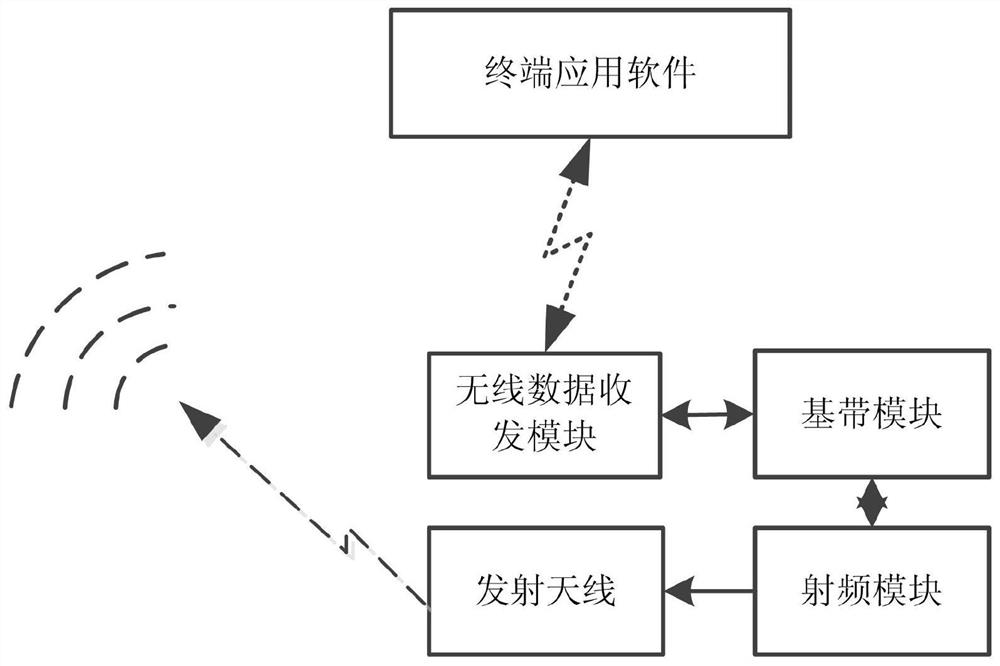
[0020] figure 1 It is a composition diagram of a hand-held navigation signal simulator of the present invention, including terminal application software, wireless data transceiver module, baseband module, radio frequency module and transmitting antenna. The terminal application software is loaded on the mobile terminal device to select the scene, and the start time of the scene is sent to the wireless data transceiver module through wireless mode, and according to the data request information reported by the wireless data transceiver module, the stored and data request The observation data and satellite navigation messages corresponding to the information are sent to the wireless data transceiver module through wireless; it is also used to display the progress of the current data delivery and the operating status of the equipment to the user in ...


PUM


Abstract

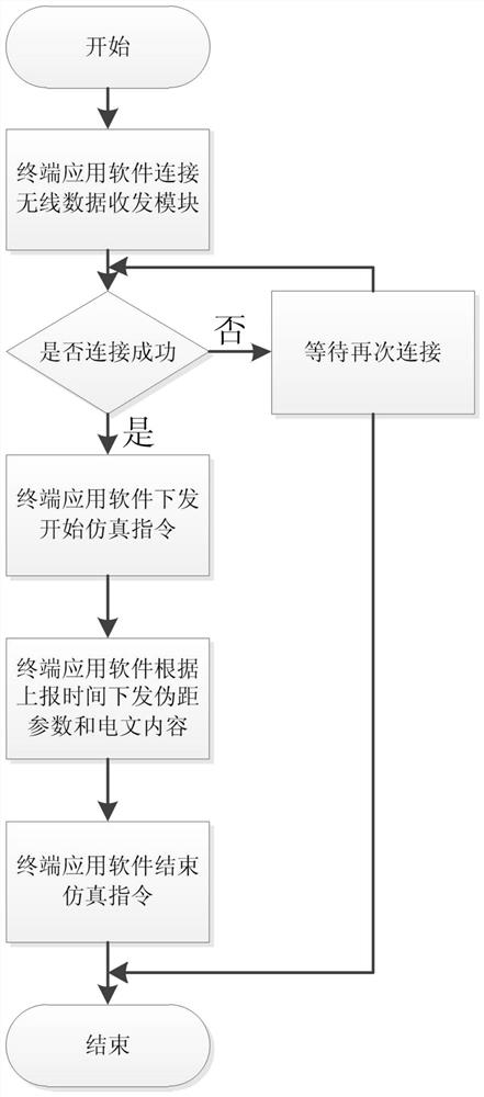
The invention relates to a hand-held navigation signal simulator, which belongs to the technical field of satellite navigation signals. Including: terminal application software, wireless data transceiver module, baseband module, radio frequency module and handheld navigation signal simulator for transmitting antenna. The terminal application software connects to the wireless data transceiver module through the wireless local area network. The terminal application software configures the parameters and output time, and sends the pseudo-range information and message content to the baseband module; the baseband module modulates and outputs the intermediate frequency navigation signal, and transmits the multiple satellite signals Combining; the radio frequency module up-converts the baseband intermediate frequency signal and outputs it to the transmitting antenna. Based on the generation of the navigation signal, the present invention realizes the hand-held function of the navigation analog signal by using the wireless communication and control mode of the local area network, and can be used and controlled conveniently and flexibly.

Description

technical field [0001] The invention belongs to the technical field of satellite navigation signals, in particular to a hand-held navigation signal simulator. Background technique [0002] At present, with the continuous use of navigation and positioning in life, Beidou and GPS are representatives of satellite navigation systems, and their navigation terminals are more and more widely used. For the rapid expansion of various needs, the forms of navigation terminals are also in diversification. In the rapid development, it is not limited to the use of military equipment, smart phones, smart watches, car navigators, etc. [0003] From design to production of each navigation terminal device, a navigation signal simulator is required to provide a simulated navigation signal environment to complete the debugging and testing of the navigation terminal device. However, the current navigation signal simulators are inconvenient to carry, or have relatively high requirements on the u...

Claims


Application Information

Patent Timeline
Patent Type & Authority Patents(China)
IPC IPC(8): G01S19/46G01S19/11
CPCG01S19/11G01S19/46
Inventor 张红敏田方礼陈锡春董立桥安玳宁
Owner NO 54 INST OF CHINA ELECTRONICS SCI & TECH GRP
Learn More