Supercharge Your Innovation With Domain-Expert AI Agents!

ArcGIS-based on-line intelligent mapping system construction method and system and mapping method

A construction method and intelligent technology, applied in the field of geographic information systems, can solve problems such as difficult desktop tools, unfavorable multi-user online, collaborative mapping, users not familiar with desktop software, etc., to achieve simple mapping operation, satisfying online and intelligent mapping the desired effect

Active Publication Date: 2019-03-08
GUANGZHOU URBAN PLANNING & DESIGN SURVEY RES INST
View PDF16 Cites 12 Cited by
  • Summary
  • Abstract
  • Description
  • Claims
  • Application Information

AI Technical Summary

Problems solved by technology

[0003] The desktop tools in commonly used geographic information system (GIS) software, such as ArcGIS Desktop, SupermapiDesktop, etc., generally include advanced geographic analysis and processing capabilities, provide powerful editing tools and a complete map production process, but traditional desktop software mainly It is aimed at relatively professional users, and the drawing functions it provides are professional and complex, and the desktop software mostly adopts a stand-alone, C / S architecture deployment mode, and the scope of use of users is limited. Various industries provide map drawing services with a wide range of users, and most of the users are not familiar with professional desktop software. In addition, using the data services and functional services provided by the smart city space-time infrastructure, fast, efficient, online, Intelligent map drawing is the core appeal of many smart city application department users
[0004] At present, the existing map drawing mostly uses the desktop tools in the above-mentioned geographic information system (GIS) software, such as ArcGIS Desktop, Supermap iDesktop, etc., and generally has the following disadvantages: 1) It is relatively professional and complicated, and is not suitable for promotion in various departments of smart cities Use: Although the above professional desktop tools include advanced geographic analysis and data processing capabilities, and provide powerful editing tools and a complete map production process, users in many departments of smart cities are often not familiar with the use of professional software, and more It is difficult to use professional desktop tools for routine map drawing operations; 2) The deployment mode of stand-alone and C / S architecture is not conducive to multi-user online and collaborative drawing: the above professional desktop tools mostly use stand-alone and C / S architecture deployment The model is mainly aimed at individual users of map making, and the scope of use of users is limited. However, the space-time infrastructure of smart cities needs to provide map making services for various departments and industries in the city, and has a wide range of users. This single-machine deployment model is obviously not conducive to multiple Online and collaborative map drawing by users; 3) Map drawing results are difficult to meet the sharing and communication of multiple users: because professional desktop tools are relatively professional and complex, and are mostly deployed in a stand-alone, C / S architecture mode, resulting in map drawing results It is difficult to share and communicate among multiple users; 4) It is difficult to make full use of cloud computing architecture for big data analysis and mapping: as big data, especially spatiotemporal big data, is more and more widely used in smart cities, users often need to Based on the analysis of spatio-temporal big data, map drawing is carried out, but the traditional desktop mapping tools do not support the cloud computing architecture, so it is difficult to make full use of the computing resources of the cloud computing center to conduct fast and efficient online analysis of spatio-temporal big data

Method used


Image

  • ArcGIS-based on-line intelligent mapping system construction method and system and mapping method
  • ArcGIS-based on-line intelligent mapping system construction method and system and mapping method
  • ArcGIS-based on-line intelligent mapping system construction method and system and mapping method

Examples


Embodiment 1

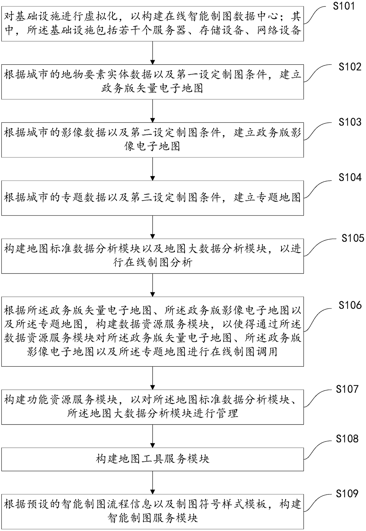
[0049] see figure 1 , which is a flowchart of an ArcGIS-based online intelligent mapping system construction method, and the ArcGIS-based online intelligent mapping system construction method includes:

[0050] S101: Virtualize the infrastructure to build an online intelligent mapping data center; wherein, the infrastructure includes several servers, storage devices, and network devices;

[0051] The present invention adopts a certain number of servers, storage devices, network devices, and urban e-government extranets to build the hardware infrastructure environment of an online intelligent mapping data center (computing center); Virtualize network equipment and the extranet of urban e-government affairs to build computing, storage, and network resource pools for the online smart mapping data center (computing center); use the GIStack for Manager tool for computing, Storage, network resource pools, etc. are managed so that mapping users can use the resources in the online in...


PUM


Abstract

The invention discloses an ArcGIS-based on-line intelligent mapping system construction method and system and a mapping method. The ArcGIS-based on-line intelligent mapping system construction methodis characterized by constructing an online intelligent cartographic data center, a map standard data analysis module, a map big data analysis module, a data resource service module, a functional resource service module, a map tool service module and an intelligent cartography service module to build an online intelligent cartography system supporting B / S mode, thereby realizing the online and intelligent cartography through a simple browser terminal, and at the same time, being simple in cartography operation, and being able to meet the needs of online and intelligent cartography of various departments in smart cities.

Description

technical field [0001] The invention relates to the technical field of geographic information systems, in particular to a method for constructing an online intelligent mapping system based on ArcGIS, a system and a mapping method. Background technique [0002] Smart city is a new concept and new model that uses the new generation of information technology such as the Internet of Things, cloud computing, big data, and geographic information integration to promote urban planning, construction, management, and service intelligence. From the above concept of smart city, geographic information System (GIS) and related technologies together with new IT technologies such as cloud computing, Internet of Things, and big data constitute the core technology of smart city construction; according to the "New Smart City" jointly issued by the National Development and Reform Commission and the Central Network Information Office Construction Inter-Ministerial Coordination Working Group 2016...

Claims


Application Information

Patent Timeline
Patent Type & Authority Applications(China)
IPC IPC(8): G06F16/29G06T17/05
CPCG06T17/05
Inventor 张鹏程杨梅何华贵杨卫军周勍
Owner GUANGZHOU URBAN PLANNING & DESIGN SURVEY RES INST
Features
  • R&D
  • Intellectual Property
  • Life Sciences
  • Materials
  • Tech Scout
  • Unparalleled Data Quality
  • Higher Quality Content
  • 60% Fewer Hallucinations
Learn More