Polygonal land parcel segmentation method and device, storage medium and electronic equipment

A technology of polygons and plots, which is applied in the fields of storage media, electronic equipment, devices, and polygonal plot segmentation methods, and can solve the problems that non-convex polygonal plot boundaries and obstacle boundaries cannot be applied.

Active Publication Date: 2019-06-25
SHENYANG WOOZOOM TECH CO LTD
View PDF7 Cites 8 Cited by
  • Summary
  • Abstract
  • Description
  • Claims
  • Application Information

AI Technical Summary

Problems solved by technology

[0004] The present invention provides a polygonal plot segmentation method, which solves the problem that the prior art plot segmentation method is only appl...

Method used


Image

  • Polygonal land parcel segmentation method and device, storage medium and electronic equipment
  • Polygonal land parcel segmentation method and device, storage medium and electronic equipment
  • Polygonal land parcel segmentation method and device, storage medium and electronic equipment

Examples


Embodiment 1

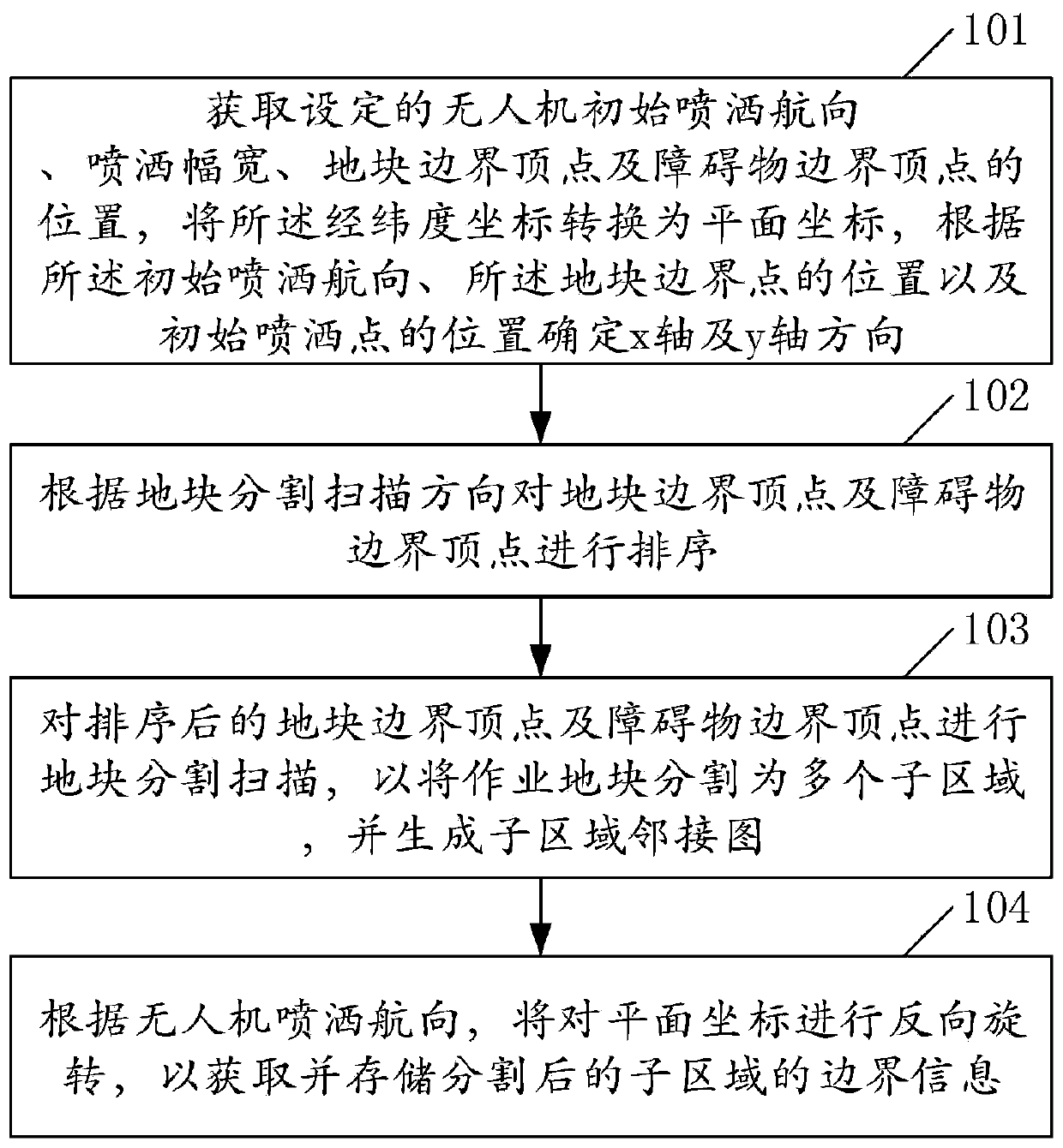
[0035] Embodiment 1 of the present invention provides a polygonal block segmentation method, such as figure 1 shown, including:

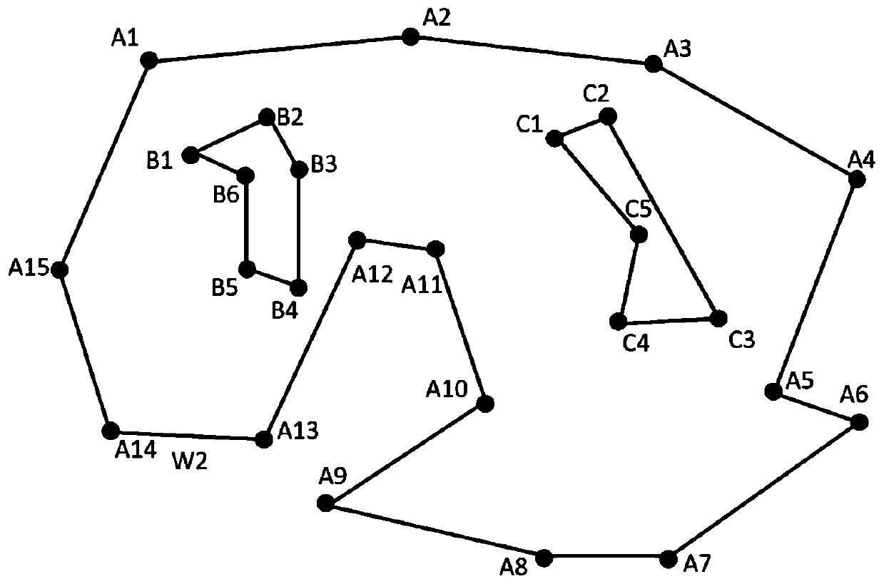
[0036] Step 101. Obtain the set drone's initial spraying heading, spraying width, position of plot boundary apex and obstacle boundary apex, convert the latitude and longitude coordinates into plane coordinates, according to the initial spraying heading, the ground The position of the block boundary point and the position of the initial spraying point determine the x-axis and y-axis directions;

[0037] Wherein, the initial spraying course is the positive direction of the x-axis; the spraying course can be changed during the spraying process. The two-dimensional coordinate plane can be customized. For example, the vertical upward direction in the plane can be the positive direction of the x-axis, and the y-axis can be the horizontal direction. In addition, the positive direction of the y-axis can be determined according to the location of the plot....

Embodiment 2

[0064] Embodiment 2 of the present invention may further include a preprocessing step before step 102 of Embodiment 1, wherein the preprocessing step includes at least one of the following:

[0065] 1. Determine whether the plot boundaries intersect. When the plot boundaries intersect, instruct the user to re-enter the latitude and longitude coordinates of the plot boundary vertices;

[0066] 2. Shrink the border vertices of the plot by a preset distance, and expand the border vertices of obstacles by a preset distance;

[0067] Among them, the retraction of the vertices of the boundary of the plot can prevent the drone from flying outside the boundary due to the error of the sampling point or the control error, causing danger; Into the obstacle, danger occurs.

[0068] 3. According to the obstacle boundary formed by the obstacle boundary vertices, judge whether the obstacles intersect. When there is an intersecting obstacle, select the outer boundary vertex of the intersecti...

Embodiment 3

[0072] Embodiment 3 of the present invention provides a polygonal plot segmentation device, such as Figure 10 shown, including:

[0073] The acquisition module 810 is used to obtain the set drone's initial spraying heading, spraying width, the position of the plot boundary apex and the obstacle boundary apex, convert the latitude and longitude coordinates into plane coordinates, according to the initial spraying heading, The position of the boundary point of the plot and the position of the initial spraying point determine the directions of the x-axis and the y-axis, wherein the initial spraying course is the positive direction of the x-axis;

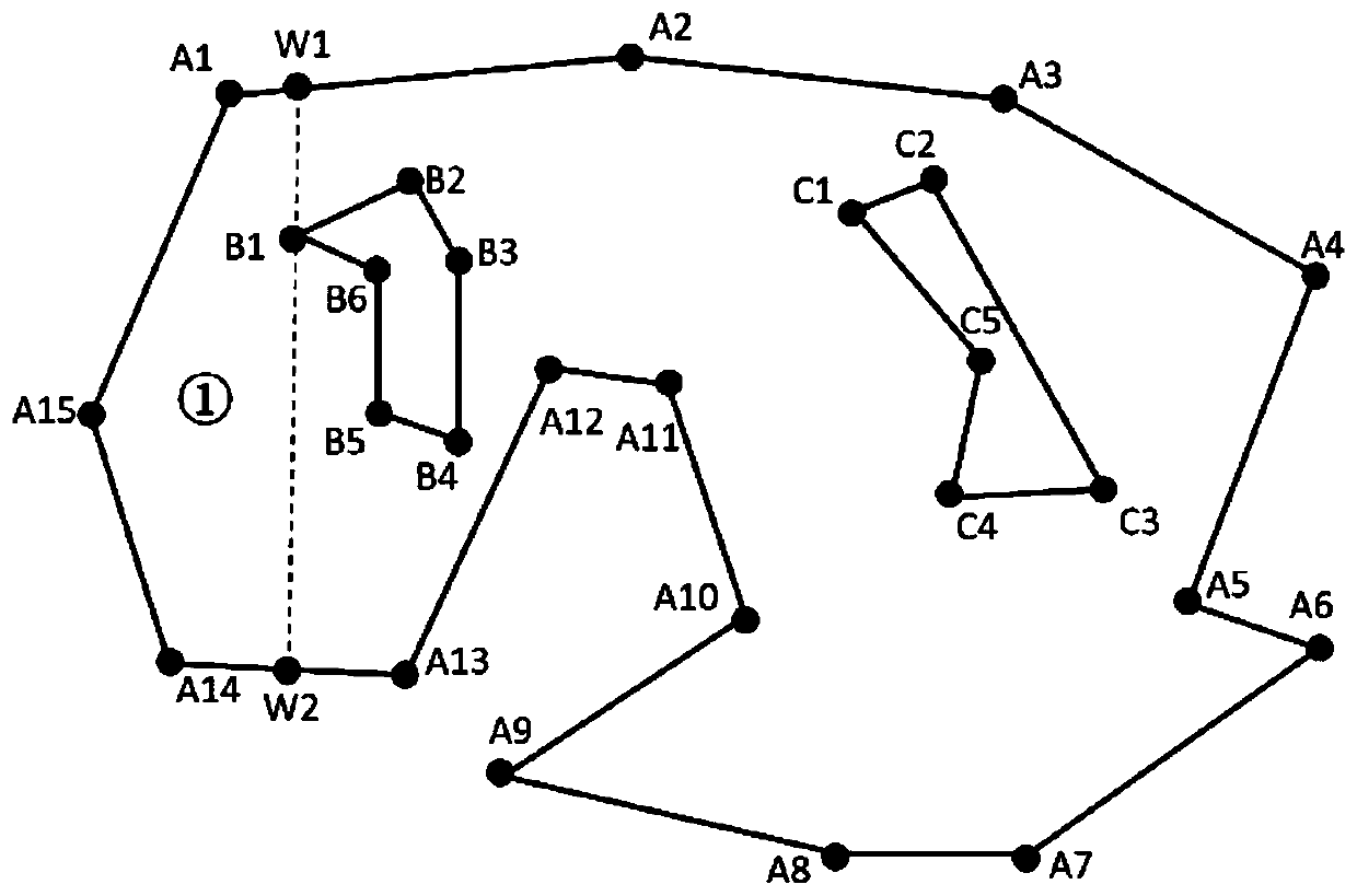
[0074] The sorting module 820 is used to sort the plot boundary vertices and obstacle boundary vertices according to the plot segmentation scanning direction;

[0075] The segmentation scanning module 830 is used to perform segmentation scanning on the sorted plot boundary vertices and obstacle boundary vertices, so as to divide the o...


PUM


Abstract

The invention relates to the field of unmanned aerial vehicle plant protection. The invention discloses a polygon land parcel segmentation method, a device, a storage medium and electronic equipment.the latitude and longitude coordinates are converted into plane coordinates by obtaining the set initial spraying course of the unmanned aerial vehicle, the spraying breadth, the top points of the land parcel boundaries and the top points of the obstacle boundaries, and the x-axis direction and the y-axis direction are determined according to the initial spraying course, the positions of the landparcel boundaries and the positions of the initial spraying points; According to the land parcel segmentation scanning direction, the land parcel boundary vertexes and the obstacle boundary vertexes are sequenced; land parcel segmentation scanning is performed on the sorted land parcel boundary vertexes and obstacle boundary vertexes to segment the operation land parcel into a plurality of sub-regions, and generating a sub-region adjacency map; And according to the spraying direction of the unmanned aerial vehicle, reversely rotating the plane coordinates to obtain and store the boundary information of the segmented sub-regions. According to the method, any polygonal land parcel containing any polygonal obstacle can be divided into a plurality of simple polygonal land parcels, so that thecovering spraying operation on each divided land parcel can be realized by utilizing an existing planning method, and then the spraying operation on any polygonal land parcel is realized.

Description

technical field [0001] The invention relates to the field of drone plant protection, in particular to a polygonal plot segmentation method, device, storage medium and electronic equipment. Background technique [0002] UAV plant protection refers to the use of UAVs for agricultural, forestry and plant protection operations. The operation usually adopts autonomous flight mode (that is, the UAV automatically flies according to the set route) or semi-autonomous flight mode (the driver controls the UAV through the remote control. aircraft flight). For autonomous flight modes, route planning is an important preparatory step before operations. Route planning refers to the computer software system calculating a reasonable route covering the entire plot based on the coordinates of the farmland plot (usually the plane projection coordinate information of the plot). [0003] Before route planning, it is necessary to consider whether there are obstacles in and near the plot, and divi...

Claims


Application Information

Patent Timeline
IPC IPC(8): G06Q10/04
Inventor 齐欣任贵杰梅森宋大雷
Owner SHENYANG WOOZOOM TECH CO LTD
Why Eureka
Try Eureka