Remote Sensing Image Semantic Segmentation Method Based on Disparity Information

A remote sensing image and semantic segmentation technology, applied in the field of image processing, can solve the problem of low segmentation accuracy

Active Publication Date: 2020-12-08
XIDIAN UNIV
View PDF1 Cites 0 Cited by
  • Summary
  • Abstract
  • Description
  • Claims
  • Application Information

AI Technical Summary

Problems solved by technology

[0006] The purpose of the present invention is to overcome the deficiencies of the above-mentioned prior art, and propose a remote sensing image semantic segmentation method based on parallax information, which is used to solve the technical problem of low segmentation accuracy existing in the prior art

Method used


Image

  • Remote Sensing Image Semantic Segmentation Method Based on Disparity Information
  • Remote Sensing Image Semantic Segmentation Method Based on Disparity Information
  • Remote Sensing Image Semantic Segmentation Method Based on Disparity Information

Examples


Embodiment Construction

[0050] The present invention will be further described in detail below in conjunction with the accompanying drawings and specific embodiments.

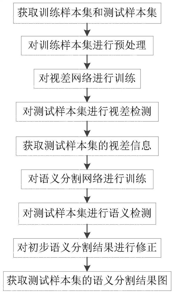
[0051] refer to figure 1 , the present invention comprises the following steps:

[0052] Step 1) Obtain training sample set and test sample set:

[0053] Obtain s remote sensing images of different areas with a size of w×h taken by two satellites in different positions on the same scene, s > 100, w > 1000, h > 1000, and all pixels of 2s remote sensing images share c semantics category, c=1,2,3,…, pair images of the same area captured by two satellites, get s remote sensing image pairs, and select s among them 1 remote sensing image pairs as the training sample set, and the rest s 2 remote sensing image pairs as the test sample set, the s 2 =s-s 1 .

[0054] In this embodiment, the remote sensing image is obtained from the video shot by the worldview-3 satellite, s=4292, w=1024, h=1024, c=5, 80% of the samples are randomly sele...


PUM


Abstract

The invention provides a remote sensing image semantic segmentation method based on parallax information, which is used for solving the technical problem of low segmentation precision in the prior art, and comprises the following implementation steps of: obtaining a training sample set and a test sample set; preprocessing the training sample set; training the parallax network; carrying out parallax detection on the test sample set; acquiring parallax information of the test sample set; training the semantic segmentation network; performing semantic detection on the test sample set; correctingthe preliminary semantic segmentation result; and obtaining a final semantic segmentation result. According to the method, left-right consistency detection LRC is conducted on the parallax result of the remote sensing image, then the semantic segmentation result is corrected through parallax information obtained through detection, a brand-new semantic segmentation fusion detection method is provided, and the semantic segmentation precision is remarkably improved. The method can be applied to practical applications such as geological detection, land utilization, urban planning, automatic driving, man-machine interaction and medical image recognition.

Description

technical field [0001] The invention belongs to the technical field of image processing, and relates to a remote sensing image semantic segmentation method, in particular to a remote sensing image semantic segmentation method based on parallax information, which can be applied to geological detection, land use, urban planning, automatic driving, human-computer interaction, Medical image recognition and other fields. Background technique [0002] Semantic segmentation refers to dividing an image into several disjoint pixel regions with certain semantic meanings based on features such as color, grayscale, and texture, and identifying the category of each region. Pixels in the same region are assigned the same color, and finally obtain an image with pixel semantic annotations. [0003] Remote sensing is a technology developed on the basis of aerial photography technology to image the earth in a specific electromagnetic spectrum through sensors on satellites. Through remote se...

Claims


Application Information

Patent Timeline
Patent Type & Authority Patents(China)
IPC IPC(8): G06T7/11G06T5/00
CPCG06T5/003G06T5/006G06T2207/10032G06T2207/20021G06T2207/20228G06T7/11
Inventor 焦李成唐旭李小雪李英萍孙龙屈嵘李玲玲郭雨薇冯志玺张梦璇丁静怡张丹
Owner XIDIAN UNIV
Why Eureka
Try Eureka