Method for early identification of urban ground deformation disasters

An early identification, ground-based technology, applied in the reflection/re-radiation of radio waves, measurement devices, instruments, etc., can solve problems such as rare application cases, and achieve the effect of preventing human misjudgment and missed judgment, and improving the recognition accuracy.

Inactive Publication Date: 2019-08-16
SICHUAN INST OF GEOLOGICAL ENG INVESTIGATION
View PDF5 Cites 11 Cited by
  • Summary
  • Abstract
  • Description
  • Claims
  • Application Information

AI Technical Summary

Problems solved by technology

However, for the early identification method of ground deformation ...

Method used


Image

  • Method for early identification of urban ground deformation disasters

Examples


Embodiment 1

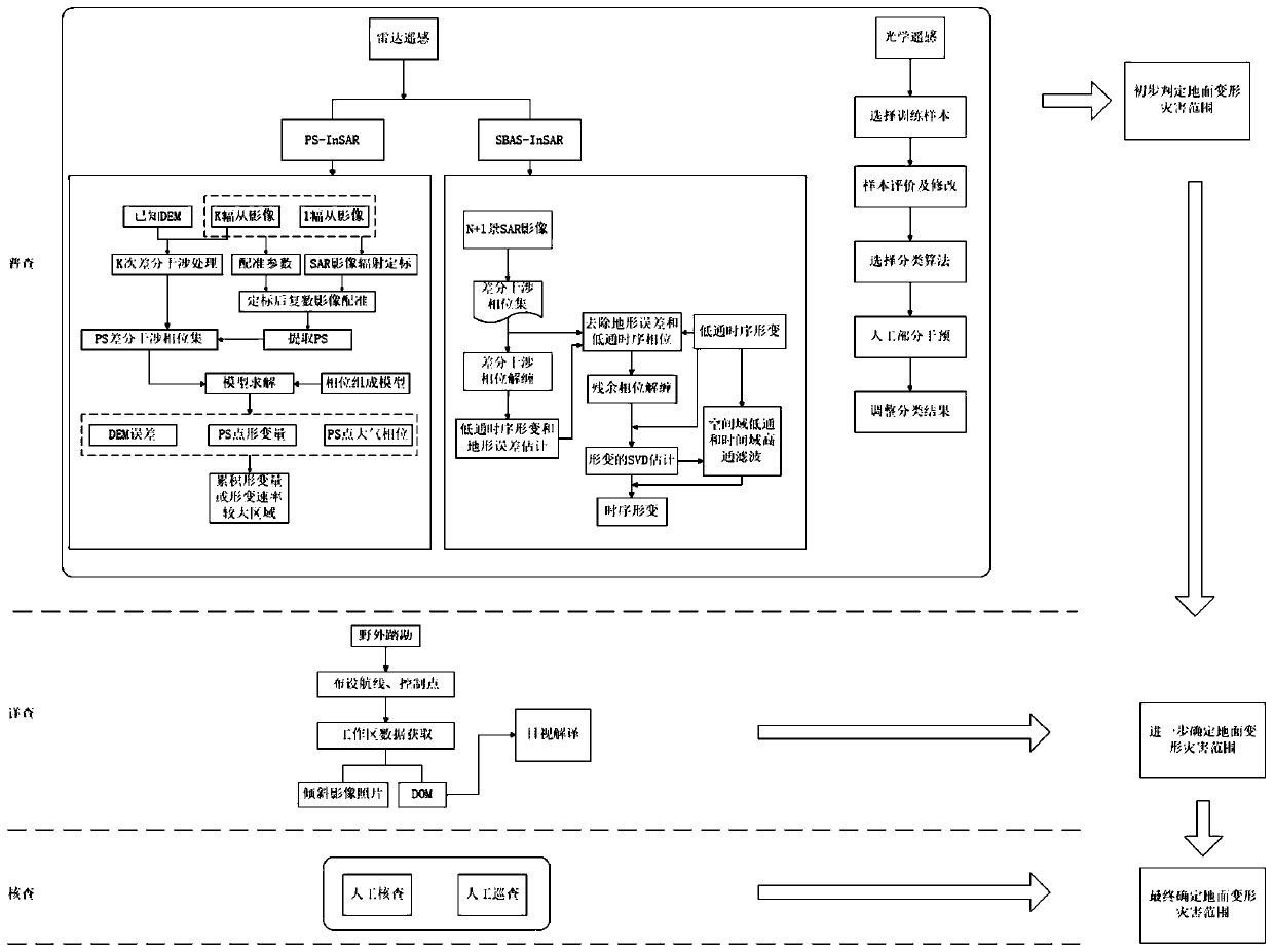
[0043] like figure 1 As shown, a method for early identification of urban ground deformation disasters includes the following steps:

[0044] Step 1: Regional census based on remote sensing technology: analyze the urban surface data obtained by radar remote sensing or optical remote sensing, conduct preliminary identification of hidden danger areas of urban surface deformation, and determine potential deformation areas;

[0045] Step 2: Detailed inspection of potential deformation zones based on UAV photogrammetry technology: Using fixed-wing and rotor UAVs as carriers, monitor the potential dangerous areas of surface deformation identified in Step 1 through photogrammetry technology, and combine the ground Monitoring station for data check and verification;

[0046] Step 3: On-site verification: including manual verification and manual inspection. For the potential hidden danger points of geological disasters delineated by the above-mentioned technical means, organize profe...

Embodiment 2

[0060] like figure 1 As shown, this implementation is further optimized on the basis of Embodiment 1. This embodiment focuses on the improvements compared with Embodiment 1, and the similarities will not be repeated. In this embodiment, it focuses on the optical remote sensing based The specific way to determine the potential deformation area is as follows:

[0061] Monitoring and identification of regional surface deformation based on optical remote sensing technology: Obtain multi-period high-resolution optical remote sensing data, through supervised classification and partial manual intervention, use the confirmed category of sample pixels to identify other unknown categories of pixels, further The area where the disaster may occur is extracted.

[0062] The specific method of the method for the sample pixel of the confirmed category to identify other unknown category pixels is as follows:

[0063] A. Select training samples

[0064] Select a certain number of training a...


PUM


Abstract

The invention discloses a method for early identification of urban ground deformation disasters, and belongs to the technical field of urban ground deformation monitoring. The method includes steps: step 1, regional general investigation based on a remote sensing technology: analyzing urban ground data obtained by radar remote sensing or optical remote sensing, preliminarily discriminating hiddenrisk regions of urban ground deformation, and determining potential deformation regions; step 2, detailed investigation of the potential deformation regions based on an unmanned aerial vehicle photography measurement technology: monitoring potential dangerous regions, identified in step 1, of ground deformation through the photography measurement technology by regarding fixed-wing and rotor-wing unmanned aerial vehicles as carriers, and performing data check and verification with the combination of a ground monitoring station; ad step 3, onsite check: organizing point-to-point check of potential geological disaster hidden risk places designated through technical means in step 1 and step 2 by personnel, and determining checked places whose ground crack widths are greater than 10 mm with sustainable development or whose sedimentation vertical displacements are greater than 30 mm with sustainable development as hidden risk regions and paying continuous attention.

Description

technical field [0001] The invention relates to the technical field of urban ground deformation monitoring, in particular to a method for early identification of urban ground deformation disasters. Background technique [0002] Some scholars have done a lot of research work on the early identification and application of earthquake disasters, and achieved certain results. Based on UAV photogrammetry technology, Ju Yuanzhen realized the early identification of Heifangtai loess landslide by using difference model and multi-period data processing and comparison; Body, Fushun West Open-pit Mine Nanbang landslide and other disasters were studied, and a set of disaster investigation, monitoring, and early identification methods based on 3D laser scanning technology were summarized; He Chaoyang et al. The points were identified, and the identification results were verified through surface displacement monitoring; based on DEM and remote sensing images, Li Xun et al. applied the pri...

Claims


Application Information

Patent Timeline
IPC IPC(8): G01C11/00G01S13/90
CPCG01C11/00
Inventor 吴森薛廉陈超谭超杨晓东陈渠波唐侨吴瑶王蕾胡泽铭齐得旭吴成波邹维勇
Owner SICHUAN INST OF GEOLOGICAL ENG INVESTIGATION
Why Eureka
Try Eureka