
A road coding method and a road matching method

A coding method and road technology, applied in the field of geographic information, can solve problems such as road data update burden

Active Publication Date: 2021-06-08
ALIBABA (CHINA) CO LTD
View PDF10 Cites 0 Cited by
  • Summary
  • Abstract
  • Description
  • Claims
  • Application Information

AI Technical Summary

Problems solved by technology

It can be seen that, in order to fully reflect the actual direction of each road, the existing technology requires a large number of points; at the same time, the existing technology must select points that can reflect the actual direction of the road, for example, the corner of the turning road must be Select a point. In this case, once the direction of the road changes, for example, the original curve is converted into a straight road, then it is necessary to re-acquire the points on this road, which brings new challenges to the update of road data. to bear

Method used


Image

  • A road coding method and a road matching method
  • A road coding method and a road matching method
  • A road coding method and a road matching method

Examples


Embodiment Construction

[0033] The embodiments of the present application will be described in detail below in conjunction with the accompanying drawings. It should be understood that the embodiments described below are only used to illustrate and explain the present application, and are not intended to limit the present application.

[0034] It should be noted that, if there is no conflict, the embodiments of the present application and various features in the embodiments can be combined with each other, and all are within the protection scope of the present application. In addition, although a logical order is shown in the flowcharts, in some cases the steps shown or described may be performed in an order different from that shown or described herein.

[0035] In some embodiments, the computing device for implementing the road coding method or the road matching method may include one or more processors (Central Processing Unit, CPU), input / output interfaces, network interfaces and memory (memory). ...


PUM


Abstract

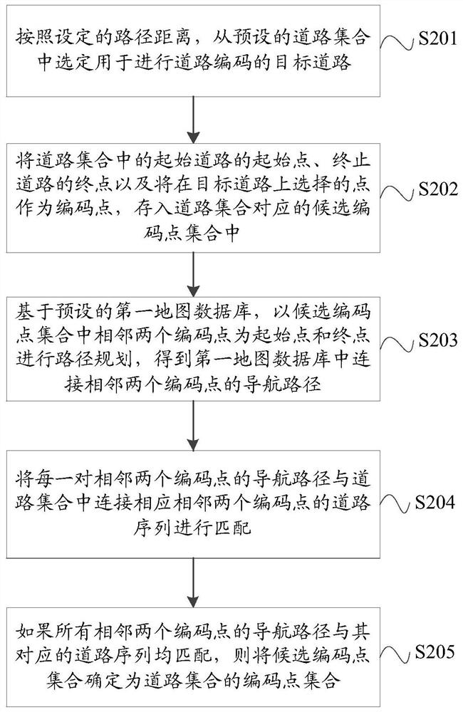
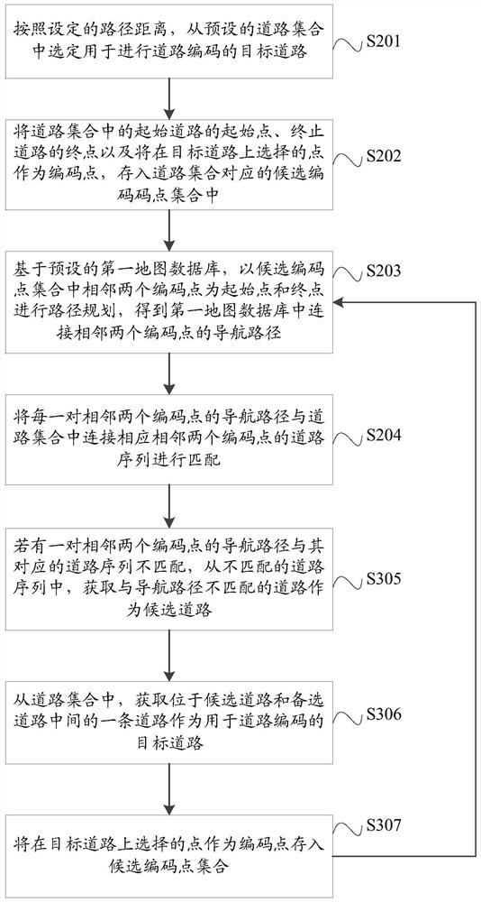
The present application discloses a road coding method and a road matching method; the above road coding method includes: selecting a target road for road coding from a preset road set according to a set path distance; The starting point of the starting road, the end point of the ending road, and the points selected on the target road as coding points are stored in the candidate coding point set corresponding to the road set; based on the preset first map database, the candidate coding point The two adjacent code points in the set are used as the starting point and the end point for path planning, and the navigation path connecting the two adjacent code points in the first map database is obtained; the navigation path and road set of each pair of adjacent two code points If the navigation paths of all adjacent two code points match their corresponding road sequences, the candidate code point set is determined as the code point set of the road set.

Description

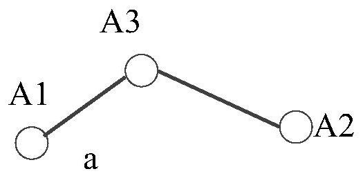
technical field [0001] The present application relates to but not limited to the technical field of geographic information, and in particular relates to a road coding method and a road matching method. Background technique [0002] Map data includes three types of vector data: point, line, and plane, among which, the roads in the real world correspond to line data. Specifically, a road can be abstracted into some discrete points, and the line formed by these discrete points can be preserved to represent the road. The inventors found that when abstracting the road into discrete points, it is necessary to ensure that these discrete points can reflect the real situation of the road. For example, when a road with turns is abstracted into discrete points, in addition to the first and last points of the road, at least the middle turning point of the road must be reserved. Such as figure 1 As shown, the road a is a road with one turn. When abstracting the road a into discrete po...

Claims


Application Information

Patent Timeline
Patent Type & Authority Patents(China)
IPC IPC(8): G01C21/32
CPCG01C21/32
Inventor 王广彬左帆
Owner ALIBABA (CHINA) CO LTD
Learn More