Comprehensive urban geographic semantic mining method based on multivariate big data

A semantic mining and big data technology, applied in data processing applications, electrical digital data processing, special data processing applications, etc., can solve problems such as no method for verification, excessive data requirements, etc.

Active Publication Date: 2019-11-12
PEKING UNIV
View PDF6 Cites 7 Cited by
  • Summary
  • Abstract
  • Description
  • Claims
  • Application Information

AI Technical Summary

Problems solved by technology

The existing work estimates the population density distribution in real time from the flow of people, but on the ...

Method used


Image

  • Comprehensive urban geographic semantic mining method based on multivariate big data
  • Comprehensive urban geographic semantic mining method based on multivariate big data
  • Comprehensive urban geographic semantic mining method based on multivariate big data

Examples


Embodiment Construction

[0070] The present invention will be further elaborated below through specific embodiments in conjunction with the accompanying drawings.

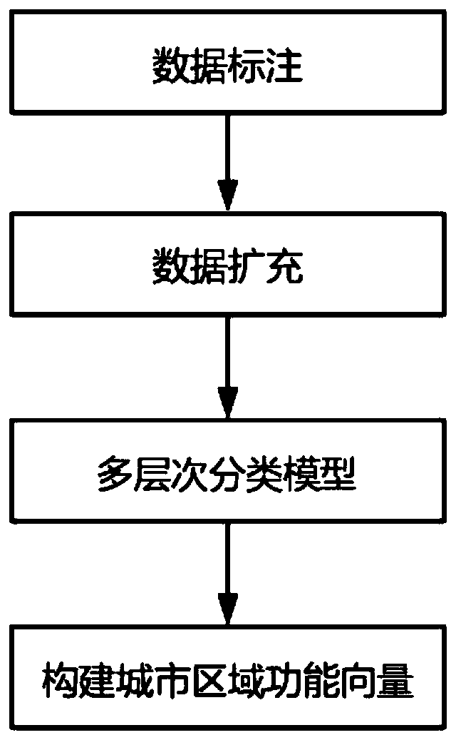
[0071] like figure 1 As shown, the multivariate big data-based comprehensive urban geographic semantic mining method of the present invention of the present invention comprehensively considers four indicators: urban regional function, urban transportation convenience distribution, building function and population density index distribution:

[0072] 1. Urban regional functions, such as figure 1 Shown:

[0073] According to the 4,975,416 microblog data with geographic location tags in Beijing in 2016 as social text data, the calculation of the urban area function includes the following steps:

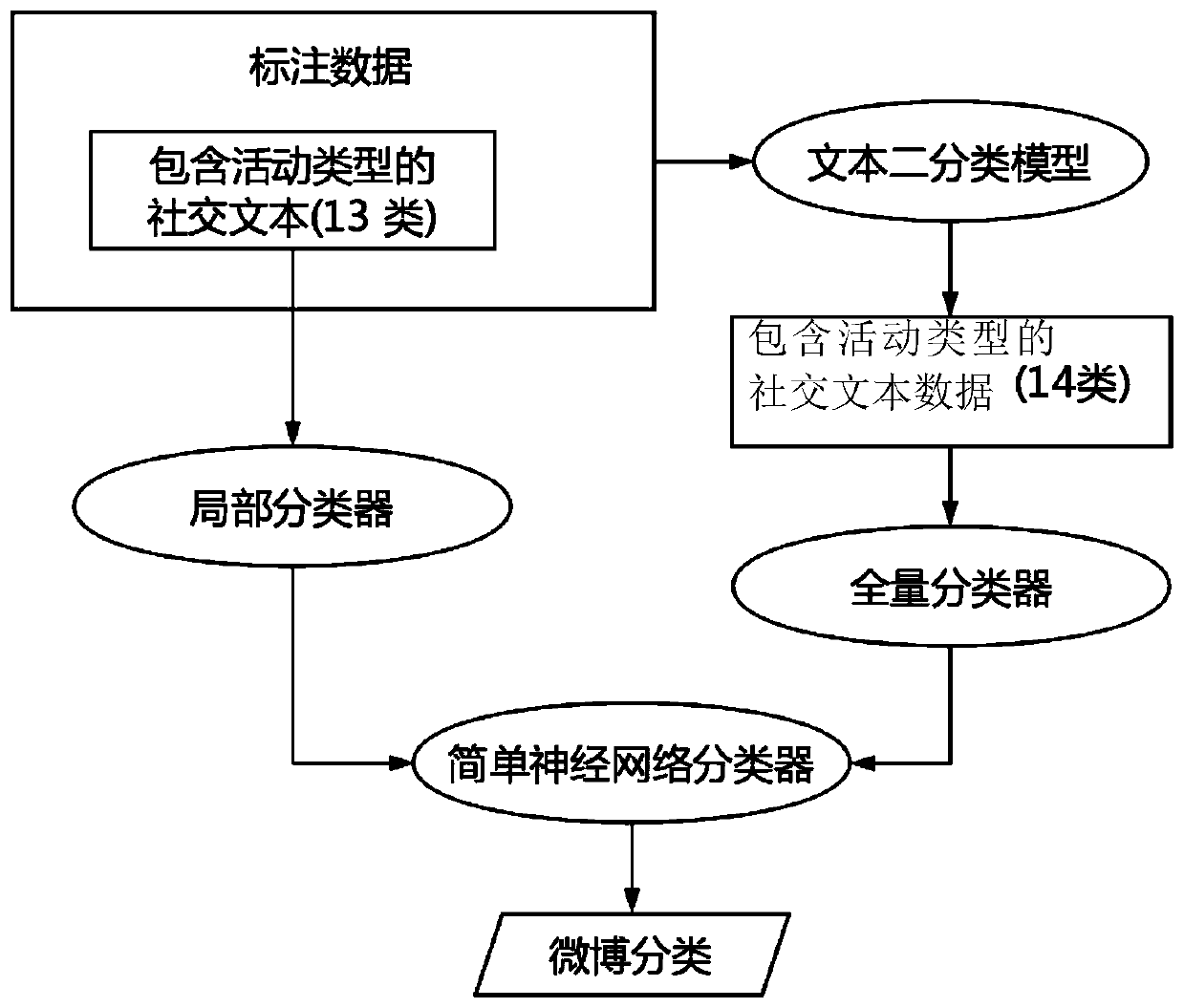
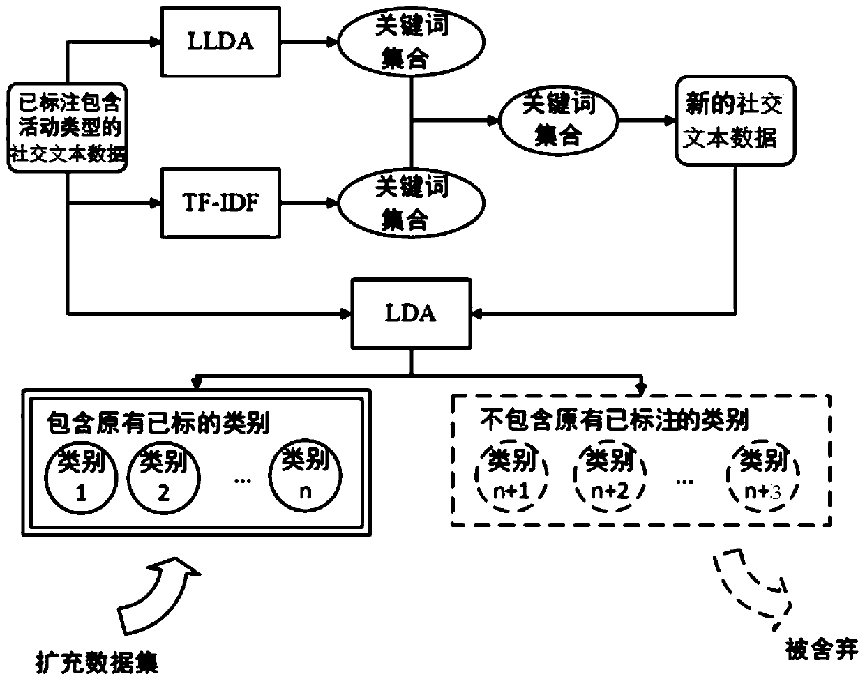
[0074] 1) Data labeling

[0075] In this embodiment, 13 activity types are selected, which are catering, sports, tourism, shopping, hotel, hospital, school, residence, office, entertainment, transportation, training, and life assistance. These 13...


PUM


Abstract

The invention discloses a comprehensive urban geographic semantic mining method based on multivariate big data. Social text data is a data source capable of best reflecting the cognition of people onurban area functions, so that the functions of urban areas are extracted by utilizing the social text data; based on the bus route data, automatic calculation is performed to obtain the relative rankof the traffic convenience of each region of the city without depending on artificially formulated rules; the urban population density distribution is analyzed from two macroscopic perspectives of thepopulation density index of the working time period of the workday and the population density index of the rest time period. According to the method, the comprehensive urban geographic semantics aredescribed from four different indexes including urban area functions, urban traffic convenience distribution, building functions and population density indexes; and in combination with the informationmined by the four indexes, different types of query requirements of different types of users can be met, and people can be better helped to comprehensively understand cities.

Description

technical field [0001] The invention relates to data analysis and mining technology, in particular to a comprehensive urban geographic semantic mining method based on multivariate big data. Background technique [0002] Urban geographic semantics is a semantic description of various information in urban areas, reflecting the characteristics of a region and people's cognition of the region. Each geographical location will have its unique semantic information. For example, as a geographical location, "Zhongguancun" includes functions such as "commercial", "office", and "food". It also has more convenient transportation and a larger population. characteristics such as density. The mining of comprehensive urban geographic semantics helps to enhance people's understanding of different regions of the city. [0003] There are many types of urban geographic semantics, such as urban regional functions, which reflect the functions provided by different regions of the city; urban tra...

Claims


Application Information

Patent Timeline
IPC IPC(8): G06F16/35G06F16/9537G06K9/62G06Q10/06G06Q50/26
CPCG06F16/35G06F16/9537G06Q10/063G06Q50/26G06F18/23213
Inventor 孙艳春黄罡刘瑜温九
Owner PEKING UNIV
Why Eureka
Try Eureka