Three-dimensional geologic model data conversion method based on Geo3DML
A technology of model data and conversion method, which is applied to the details of 3D image data, semi-structured data mapping/conversion, 3D modeling, etc. It can solve the problems of lack of geological model expression and achieve the effect of expanding the scope of application
- Summary
- Abstract
- Description
- Claims
- Application Information
AI Technical Summary
Problems solved by technology
Method used
Image


Examples
Embodiment 1
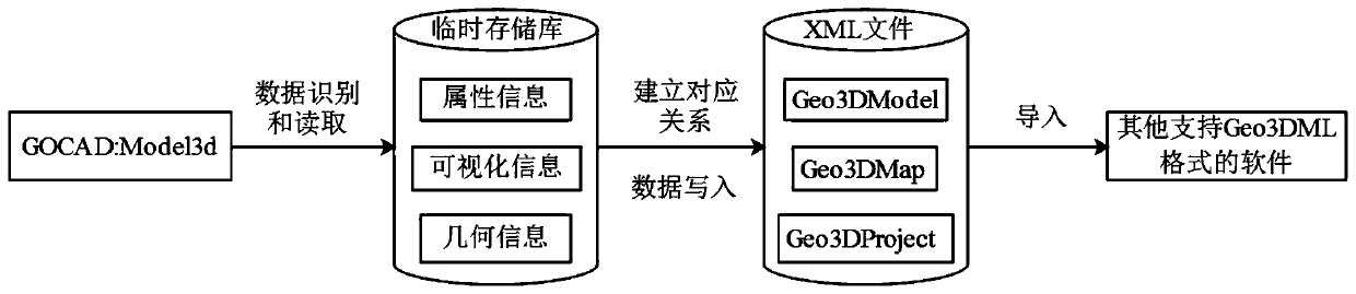
[0039] Such as figure 1 As shown, a 3D geological model data conversion method based on Geo3DML is mainly based on the Geo3DML data exchange format to convert the 3D structural model data (GOCAD ASCⅡ) established by SKUA-GOCAD into data that can be used by third-party platforms (such as MapGIS, SuperMap) The 3D model data (.xml) used, because the components of Model3d and Geo3DML include geometric information, visualization information and attribute information, and there is a one-to-one correspondence between the two in the geometric data structure, therefore, both Whether there are conversion bases and conditions on the model geometric structure or topological relationship, specifically, the steps of the specific conversion method in this embodiment are as follows:
[0040] Step 1. Identify and read the key data in the Model3d file;
[0041] Step 2. Establish a corresponding temporary storage structure;
[0042] Step 3. Temporarily store the read key data in a temporary st...
PUM
 Abstract
Description
Claims
Application Information
 - R&D
- Intellectual Property
- Life Sciences
- Materials
- Tech Scout
- Unparalleled Data Quality
- Higher Quality Content
- 60% Fewer Hallucinations
Browse by: Latest US Patents, China's latest patents, Technical Efficacy Thesaurus, Application Domain, Technology Topic, Popular Technical Reports.
© 2025 PatSnap. All rights reserved.Legal|Privacy policy|Modern Slavery Act Transparency Statement|Sitemap|About US| Contact US: help@patsnap.com