A method for extracting buildings from high-resolution remote sensing images

A technology for remote sensing images and extraction methods, applied in the field of remote sensing images, can solve problems such as reducing the degree of automation of methods and reducing accuracy

Active Publication Date: 2021-11-16
NANJING UNIV OF INFORMATION SCI & TECH
View PDF8 Cites 0 Cited by
  • Summary
  • Abstract
  • Description
  • Claims
  • Application Information

AI Technical Summary

Problems solved by technology

[0006] (1) The extraction of connected regions only depends on the similarity of specific attributes (area, shape, etc.) between adjacent pixels. Since it is not restricted by the inherent boundaries of buildings, connected regions may contain adjacent features with similar attributes pixels, thereby reducing the accuracy of the extracted MAPs;
[0007] (2) The setting of the scale parameters of MAPs should match the attribute characteristics of typical buildings in the image, and manual setting according to experience not only reduces the degree of automation of the method, but also may fall into local optimum;

Method used


Image

  • A method for extracting buildings from high-resolution remote sensing images
  • A method for extracting buildings from high-resolution remote sensing images
  • A method for extracting buildings from high-resolution remote sensing images

Examples


Embodiment Construction

[0058] The technical solutions of the present invention will be described in detail below in conjunction with the accompanying drawings.

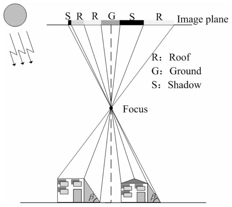
[0059] Buildings are a type of typical three-dimensional objects in urban scenes. The geometric relationship of buildings in high-resolution remote sensing images is as follows: figure 1 shown. figure 1 Among them, Roof, Ground and Shadow respectively represent the roof of the building, the adjacent ground and the shadow caused by the occlusion of light. Among them, different building roofs have different spectral absorption and reflectance due to different materials, so there may be significant differences in spectral and texture characteristics. However, pixels belonging to the roof of the same building have strong spectral and texture coherence, thus appearing as homogeneously connected regions constrained by building boundaries. In terms of geometric features, buildings usually appear as rectangles or other regular shapes, and morphol...


PUM


Abstract

The invention discloses a method for extracting buildings from high-resolution remote sensing images. Firstly, the candidate object set is extracted by combining image segmentation and shadow detection technologies; secondly, based on the scale parameter adaptive extraction strategy, the differential attribute profile is constructed under the constraints of object boundaries to obtain the initial building set; finally, according to the class separability, the Uncertain objects in this set are extracted, and secondary discrimination is performed to obtain the final building extraction result. The invention improves the performance of remote sensing image building extraction in urban scenes with many types of ground objects.

Description

technical field [0001] The invention belongs to the field of remote sensing images, in particular to a method for extracting buildings from remote sensing images. Background technique [0002] With the successful operation and continuous improvement of various high-resolution remote sensing platforms, high-resolution remote sensing images have been widely used in many fields, including geographic data update, urban thematic map production, and multi-angle urban classification analysis. Among them, the semantic labeling of urban areas based on high-resolution remote sensing images, especially the automatic recognition and extraction of buildings usually plays an important role in these practical applications, and has always been one of the research hotspots in the field of remote sensing. [0003] Compared with traditional mid- and low-resolution remote sensing images, high-resolution remote sensing images contain richer building detail information, clearer outlines and struc...

Claims


Application Information

Patent Timeline
Patent Type & Authority Patents(China)
IPC IPC(8): G06K9/00G06K9/34
CPCG06V20/176G06V10/267
Inventor 王超马晓迪张丛光申祎仇星吴昊天
Owner NANJING UNIV OF INFORMATION SCI & TECH
Why Eureka
Try Eureka