Photographing control method and device of unmanned aerial vehicle, unmanned aerial vehicle and storage medium

A control method and unmanned aerial vehicle technology, which is applied in the field of unmanned aerial vehicle surveying and mapping, and can solve problems such as lack of surveying and mapping data

Pending Publication Date: 2020-01-21
GUANGZHOU XAIRCRAFT TECH CO LTD
View PDF12 Cites 4 Cited by
  • Summary
  • Abstract
  • Description
  • Claims
  • Application Information

AI Technical Summary

Problems solved by technology

Therefore, there is no image of area A2 in the photos obtained from the final surveying and mapping, and when the surveying and mapping data is generated using the later software, the data of the surveying and mapping data will be missing

Method used


Image

  • Photographing control method and device of unmanned aerial vehicle, unmanned aerial vehicle and storage medium
  • Photographing control method and device of unmanned aerial vehicle, unmanned aerial vehicle and storage medium
  • Photographing control method and device of unmanned aerial vehicle, unmanned aerial vehicle and storage medium

Examples


Embodiment 1

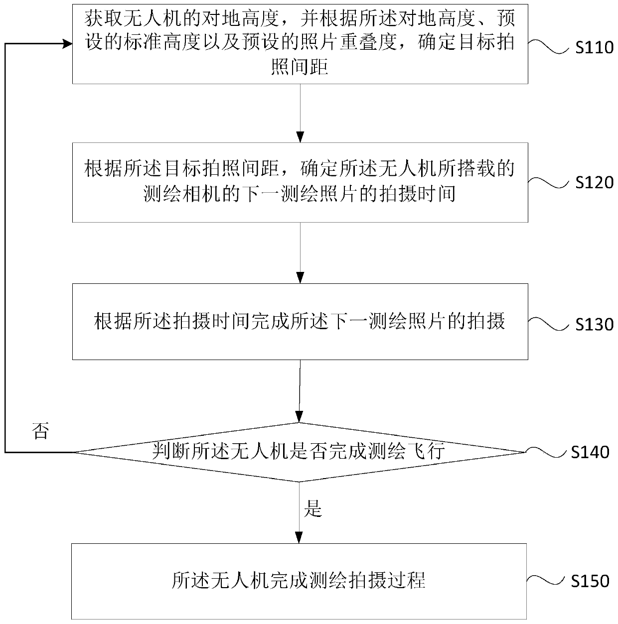
[0045] figure 2 This is a flowchart of a drone camera control method provided in the first embodiment of the present invention. This embodiment can be applied to the situation where the drone is used to complete surveying and mapping tasks. The method can be executed by the drone camera control device The device can be implemented by software and / or hardware, and can generally be integrated in a drone, specifically including the following steps:

[0046] Step 110: Obtain the ground height of the drone, and determine the target photographing distance according to the ground height, the preset standard height, and the preset photo overlap;

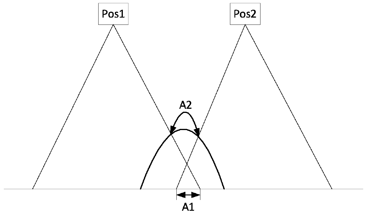
[0047] Among them, unmanned aerial vehicles are unmanned aircraft operated by radio remote control equipment and self-provided program control devices, or operated by on-board computers completely or intermittently autonomously. The altitude of the drone is the distance between the current location of the drone and the ground. figure 1 In the ph...

Embodiment 2

[0060] image 3 It is a flowchart of a photographing control method of a drone in the second embodiment of the present invention. On the basis of the above-mentioned embodiment, the embodiment of the present invention calculates the distance between photographing targets according to the height of the drone on the ground, and according to the target The calculation of the photographing interval for the next photographing time is specified. The steps of this embodiment include:

[0061] Step 210: Control the drone to fly at the standard altitude;

[0062] Wherein, the standard height is determined by a preset standard ground resolution, and the standard photo interval is determined by the standard ground resolution and the preset photo overlap.

[0063] Among them, the relationship between height and ground resolution is: H=(f*GSD) / a. Among them, H is the height, GSD is the ground resolution, and the ground resolution is also called the spatial resolution, which refers to the ability...

Embodiment 3

[0091] Figure 4 It is a schematic structural diagram of a photographing control device of a drone in the third embodiment of the present invention. The photographing control device of the drone includes: a target photographing distance determination module 310, a photographing time determination module 320, and a return execution module 330, wherein :

[0092] The target photographing distance determining module 310 is configured to obtain the ground height of the drone, and determine the target photographing distance according to the ground height, the preset standard height, and the preset photo overlap;

[0093] The shooting time determining module 320 is configured to determine the shooting time of the next surveying and mapping photo of the surveying and mapping camera carried by the drone according to the target shooting distance;

[0094] The return execution module 330 is configured to return to execute the operation of obtaining the ground height of the drone after the shoo...


PUM


Abstract

The embodiment of the invention discloses a photographing control method and device of an unmanned aerial vehicle, the unmanned aerial vehicle and a storage medium. The method comprises the followingsteps: acquiring the height to the ground of the unmanned aerial vehicle, and determining a target photographing interval according to the height to the ground, a preset standard height and a preset photo overlapping degree; determining the photographing time of the next surveying and mapping photo of a surveying and mapping camera carried by the unmanned aerial vehicle according to the target photographing interval; and after the photographing of the next surveying and mapping photo is completed according to the photographing time, returning to execute the operation of acquiring the height tothe ground of the unmanned aerial vehicle until the unmanned aerial vehicle completes surveying and mapping flight. According to the embodiment of the invention, the height to the ground of the unmanned aerial vehicle is acquired, then a new photographing interval is calculated, and the time of the next photographing is determined, so that the real-time adjustment of the photographing interval and the photographing time is realized, and the unmanned aerial vehicle can meet the requirement of the heading overlapping degree in the surveying, mapping and photographing processes.

Description

Technical field [0001] The embodiment of the present invention relates to drone surveying and mapping technology, and in particular to a drone camera control method, device, drone and storage medium. Background technique [0002] UAV photogrammetry has increasingly become an important new surveying and mapping method. It has the characteristics of long flight time, low cost, and flexible maneuverability. It is an important supplement to satellite remote sensing and manned aerial remote sensing. [0003] Traditional drone surveying and mapping tasks include various surveying and mapping parameters, such as GSD (Ground Sample Distance), photo overlap, photo interval, and flight speed. These surveying and mapping parameters are set before the flight surveying and mapping, and will not change during the flight. In such figure 1 In the photographing schematic diagram of the drone flying surveying and mapping the highly undulating ground environment shown, the drone flies from Pos1 to P...

Claims


Application Information

Patent Timeline
Patent Type & Authority Applications(China)
IPC IPC(8): G05D1/10
CPCG05D1/101
Inventor 吴泽远
Owner GUANGZHOU XAIRCRAFT TECH CO LTD
Why Eureka
Try Eureka