A method for making texture symbols of land use classification thematic maps

A technology of thematic maps and textures, which is applied in the field of making texture symbols of land use classification thematic maps, can solve problems such as lack of clear semantic connotation of map symbols, inability to quantitatively express land types, and no successful cases, etc., to achieve easy information transmission, The effect of clear semantic connotation and perfect expression

Active Publication Date: 2022-01-25
CHINA UNIV OF GEOSCIENCES (BEIJING)
View PDF5 Cites 0 Cited by
  • Summary
  • Abstract
  • Description
  • Claims
  • Application Information

AI Technical Summary

Problems solved by technology

However, there are no successful cases for the expression of large-scale land use classification maps
At the same time, this method mainly virtualizes the surface landscape in a freehand way, which does not meet the requirement that map symbols must have clear semantic connotations
[0024] 3. The current land use classification symbols are static abstract symbols, unable to quantitatively express changes in land types

Method used


Image

  • A method for making texture symbols of land use classification thematic maps
  • A method for making texture symbols of land use classification thematic maps
  • A method for making texture symbols of land use classification thematic maps

Examples


Embodiment Construction

[0080] In order to make the object, technical solution and advantages of the present invention clearer, the present invention will be further described in detail below with reference to the accompanying drawings and examples.

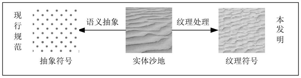
[0081] Texture refers to the texture (smooth, rough, delicate, etc.) of the surface of the object on the image, and is generally divided into different levels by smoothness / roughness. Texture is not only dependent on surface features, but also related to the angle of light, which is a changing value. Image texture is a visual feature that reflects the homogeneity phenomenon in the image, and it reflects the slow-changing or periodic-changing surface structure organization and arrangement properties of the object surface. Remote sensing image textures generally correspond to the corresponding surface object types. The basic idea of ​​the present invention is to construct texture symbols with special semantic connotations (such as figure 1 As shown), o...


PUM


Abstract

The invention discloses a method for making texture symbols of a thematic map of land use classification, comprising: texture material interception; main color extraction; color clustering; texture skeleton extraction; tiling feeling removal; and texture library construction. The advantages of the present invention are: the definition and classification of texture symbols are given, and the production process of texture symbols is clarified; the natural texture symbols and symbolic texture symbols used have clear semantic connotations, and are easier to transmit map information; the texture and texture of maps are improved. A sense of hierarchy; it can be directly used in production, providing basic support for land use survey mapping, and at the same time providing a solution for large-scale mapping of natural resource survey results. Improve the expression of the land use status classification thematic map.

Description

technical field [0001] The invention relates to the technical field of map symbols, in particular to a method for making texture symbols of land use classification thematic maps. Background technique [0002] Maps are composed of map symbols, so map symbols are also called map language, which is the basic carrier and medium for people to understand the world. Usually, map symbols include three categories: line symbol, color symbol and annotation (text description on the map, including text and numbers), which are used to represent the spatial distribution, quantity, quality and other characteristics of cartographic objects. [0003] Generally, line-dash symbols are divided into point symbols, line symbols and surface symbols according to their basic shapes. [0004] Point-like symbols: usually an overview and abstraction of point-like natural objects, their position has a clear positioning concept, while the size of the symbol only has the concept of classification and has ...

Claims


Application Information

Patent Timeline
Patent Type & Authority Patents(China)
IPC IPC(8): G06F16/29G06F16/51G06F16/55G06F16/583G06V10/56G06V20/13
CPCG06F16/29G06F16/51G06F16/55G06F16/5838G06T7/11G06T7/40G06T7/90G06T2207/10024G06V20/13G06V10/56G06V10/54G06F18/23G06T7/13G06F16/5862G06T5/002
Inventor 付宗堂王雨双陈栋
Owner CHINA UNIV OF GEOSCIENCES (BEIJING)
Why Eureka
Try Eureka