Method and terminal for processing road data and interest point data in map

A road data and processing method technology, applied in the field of data processing, can solve problems such as large storage space, and achieve the effects of avoiding data redundancy, occupying less storage space, and reducing the amount of data transmission

Active Publication Date: 2020-03-17
ALIBABA (CHINA) CO LTD
View PDF11 Cites 6 Cited by
  • Summary
  • Abstract
  • Description
  • Claims
  • Application Information

AI Technical Summary

Problems solved by technology

[0007] Existing offline map data takes up a lot of storage space

Method used


Image

  • Method and terminal for processing road data and interest point data in map
  • Method and terminal for processing road data and interest point data in map
  • Method and terminal for processing road data and interest point data in map

Examples


Embodiment Construction

[0025] In order to make the purpose, technical solution and advantages of the present invention more clear, the embodiments of the present invention will be described in detail below in conjunction with the accompanying drawings. It should be noted that, in the case of no conflict, the embodiments in the present application and the features in the embodiments can be combined arbitrarily with each other.

[0026] In offline map data, both rendering data and navigation data contain road shape point data, and the two are redundantly stored. In addition, a piece of POI data is stored in the rendering data, and a piece of POI data is also stored in the offline search data. The redundant storage of the two will cause a waste of storage space.

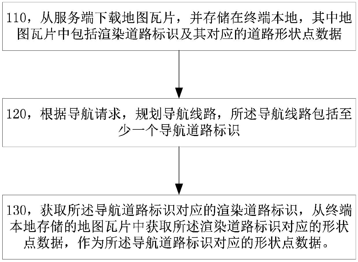
[0027] In an exemplary embodiment of the present invention, a road data processing method in a map is proposed, such as figure 1 As shown, the method includes:

[0028] Step 110, download map tiles from the server and store them locally in...


PUM


Abstract

The invention discloses a method and a terminal for processing road data and interest point data in a map. During navigation, a rendered road sign corresponding to a navigation road sign is obtained,and then shape point data corresponding to the rendered road sign is obtained from an offline map tile to serve as shape point data corresponding to the navigation road sign. A terminal further downloads interest point data associated with a display level from a server and stores the interest point data, and the interest point data corresponding to the display level can be obtained from the locally stored interest point data during map interface display and offline search. The method is advantaged in that functions of navigation, interest point search and the like can be realized by using offline map data with small data volume, data redundancy is avoided, the data transmission quantity can be reduced, and the occupied storage space is small.

Description

technical field [0001] The present application relates to, but is not limited to, data processing technology, and more specifically, relates to a method and terminal for processing road data and point-of-interest data in a map. Background technique [0002] In order to provide users with map navigation services in scenarios such as no network, offline map data can be downloaded from the server and stored locally in the terminal in the prior art, where the offline map data can include: rendering data, navigation data and offline search data. [0003] Based on offline map data, functions such as rendering, navigation, and offline search can be implemented locally on the terminal, or in other words, the rendering function, navigation function, and offline search function in the navigation system can use offline map data. At present, the data in the data set used by the rendering function, navigation function and offline search function are all vector data, which are independent...

Claims


Application Information

Patent Timeline
IPC IPC(8): G01C21/34G01C21/36
CPCG01C21/3476G01C21/3644
Inventor 宋峰张健
Owner ALIBABA (CHINA) CO LTD
Why Eureka
Try Eureka