Irrigation water effective utilization coefficient measuring and calculating method based on remote sensing

A technology of utilization coefficient and irrigation water, applied in the field of farmland water conservancy research, it can solve the problems of large influence of measurement results, difficult selection of typical fields, limited manual monitoring range, etc., and achieve high efficiency.

Active Publication Date: 2020-04-28
PEARL RIVER HYDRAULIC RES INST OF PEARL RIVER WATER RESOURCES COMMISSION
View PDF5 Cites 5 Cited by
  • Summary
  • Abstract
  • Description
  • Claims
  • Application Information

AI Technical Summary

Problems solved by technology

[0005] The purpose of the present invention is to overcome the shortcomings and deficiencies of the prior art, and provide a method for calculating the effective utilization coefficient of irrigation water based on remote sensing. It is difficult to select typical fields, the scope of manual monitoring is limited, the phenomenon of point-to-area is prominent, and the measurement results are greatly affected by the level of monitoring personnel.

Method used


Image

  • Irrigation water effective utilization coefficient measuring and calculating method based on remote sensing
  • Irrigation water effective utilization coefficient measuring and calculating method based on remote sensing
  • Irrigation water effective utilization coefficient measuring and calculating method based on remote sensing

Examples


Embodiment

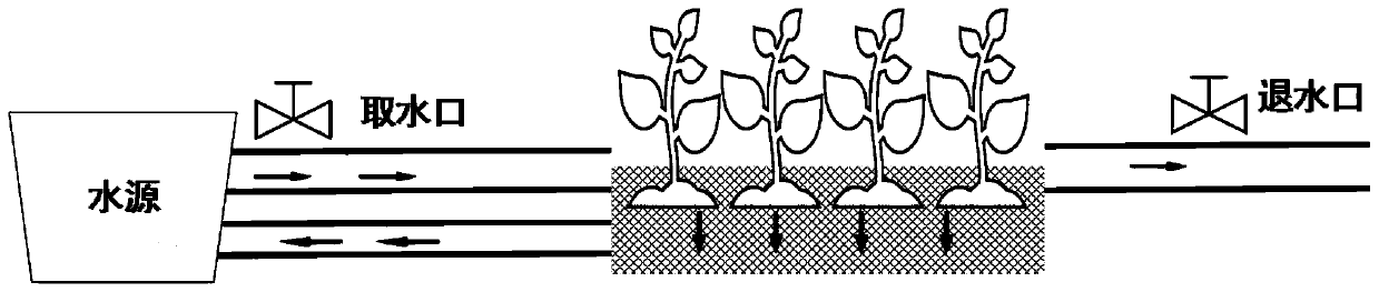
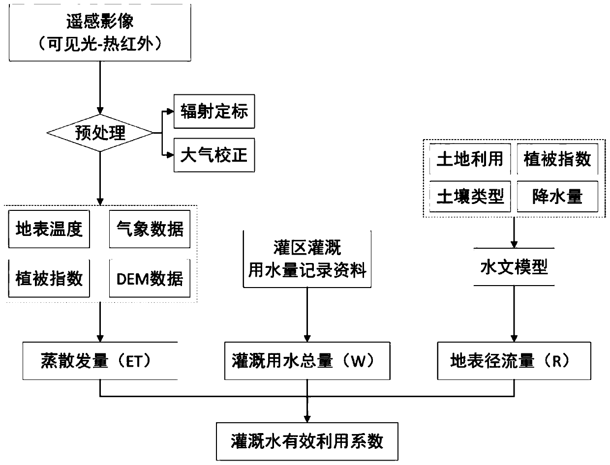
[0065] Such as figure 1 As shown, this embodiment provides a method for calculating the effective utilization coefficient of irrigation water based on remote sensing. The method is based on data such as remote sensing images, irrigation water consumption records in irrigation areas, soil type data, land use data, vegetation data, and precipitation. The calculation of effective utilization coefficient of irrigation water can be realized. Specifically, this embodiment takes Guangzhou City, China as an example, to describe in detail the process of measuring and calculating the effective utilization coefficient of irrigation water using the method of the present invention. according to figure 1 Shown method flowchart, method comprises steps:

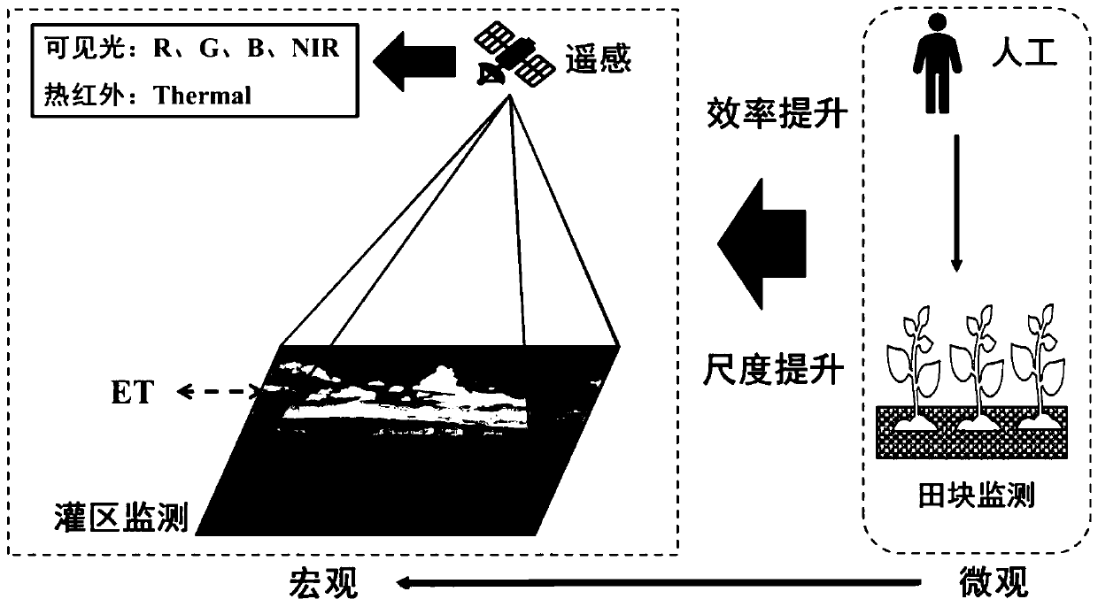
[0066] S1: Obtain remote sensing images containing visible light and thermal infrared bands, and perform preprocessing.

[0067] The remote sensing images can mainly use MODIS satellite images and Landsat series satellite images, and the ...


PUM


Abstract

The invention discloses an irrigation water effective utilization coefficient measuring and calculating method based on remote sensing, and the method comprises the steps: (1) obtaining a remote sensing image containing visible light and thermal infrared bands, and carrying out the preprocessing; (2) acquiring meteorological data and digital elevation model data; (3) acquiring irrigation water consumption data of each time in the irrigation area; (4) calculating the total evapotranspiration of the irrigation area; (5) acquiring soil type data, land utilization data, vegetation data and precipitation data, and calculating the total surface runoff in the irrigation area through a hydrological model; and (6) measuring and calculating the effective utilization coefficient of irrigation water.The method overcomes the defects that an existing head-tail measuring and calculating method is high in requirement for the agricultural metering rate, typical fields are difficult to select in the actual operation process of a complex irrigation area, the manual monitoring range is limited, the point-to-face phenomenon is prominent, and the measuring result is greatly influenced by the level of monitoring personnel; and the method has the advantages of being large in scale, efficient and accurate.

Description

technical field [0001] The invention relates to the field of farmland water conservancy research, in particular to a method for measuring and calculating the effective utilization coefficient of irrigation water based on remote sensing. Background technique [0002] When the irrigation area is irrigated, in addition to a part of the irrigation water being consumed by the irrigated crops, part of it is lost in the process of water delivery, water distribution and irrigation, and this part of the water becomes non-productive water loss. These losses include seepage loss, evaporation loss, field surface loss, drainage loss and running water loss, etc. The effective utilization coefficient of irrigation water refers to the amount of net water that can be used by crops during irrigation divided by the total amount of irrigation water taken by the irrigation system. As the main indicator of the red line of agricultural water use efficiency, the effective utilization coefficient o...

Claims


Application Information

Patent Timeline
Patent Type & Authority Applications(China)
IPC IPC(8): G06F30/20G06K9/00G06F111/10
CPCG06V20/13
Inventor 王行汉刘超群扶卿华
Owner PEARL RIVER HYDRAULIC RES INST OF PEARL RIVER WATER RESOURCES COMMISSION
Why Eureka
Try Eureka