Land value evaluation method and system

A value assessment and land technology, applied in the field of land value assessment methods and systems, can solve the problems of different land to be assessed and low reference value of land assessment, and achieve the effect of improving the reference value

Inactive Publication Date: 2020-06-09
中冠工程管理咨询有限公司
View PDF0 Cites 0 Cited by
  • Summary
  • Abstract
  • Description
  • Claims
  • Application Information

AI Technical Summary

Problems solved by technology

[0003] The above-mentioned existing technical solutions have the following defects: in the method of market comparison, the user needs to obtain the land price that has been traded in the near future, but different users have different experiences, and different people evaluate and correct. The results of the land value of the land to be appraised will be quite different, and thi...

Method used


Image

  • Land value evaluation method and system
  • Land value evaluation method and system
  • Land value evaluation method and system

Examples


Embodiment 1

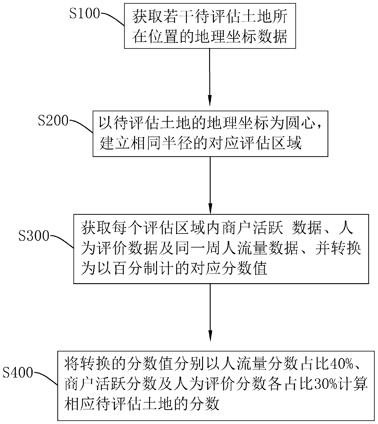
[0069] refer to figure 1 , is a kind of land value evaluation method disclosed by the present invention, comprising:

[0070] Step S100, acquiring geographical coordinate data of the locations of several lands to be evaluated.

[0071] In this embodiment, the land to be evaluated is preferably the land with several buildings built and in use, and the way to obtain the geographical coordinate data of the land to be evaluated is preferably GPS positioning.

[0072] Step S200, taking the geographic coordinates of the land to be evaluated as the center, establishing a corresponding evaluation area with the same radius.

[0073] In this embodiment, the set circle center position is the center position of the land to be evaluated, and the radius of the evaluation area is preferably 100 meters, that is, the evaluation area is a circular area with a radius of 100 meters.

[0074] In step S300, merchant activity data, human evaluation data, and traffic data of the same week are acqui...

Embodiment 2

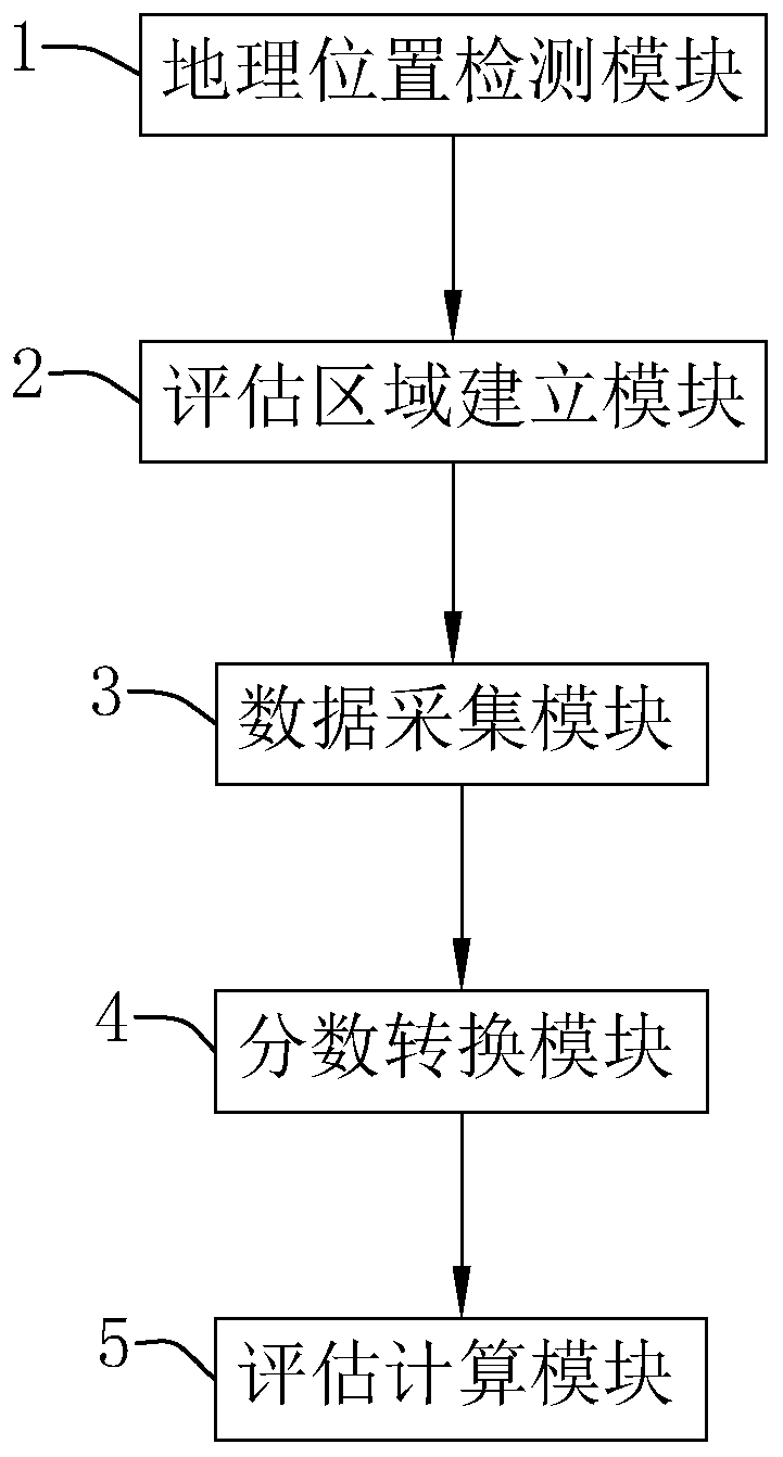
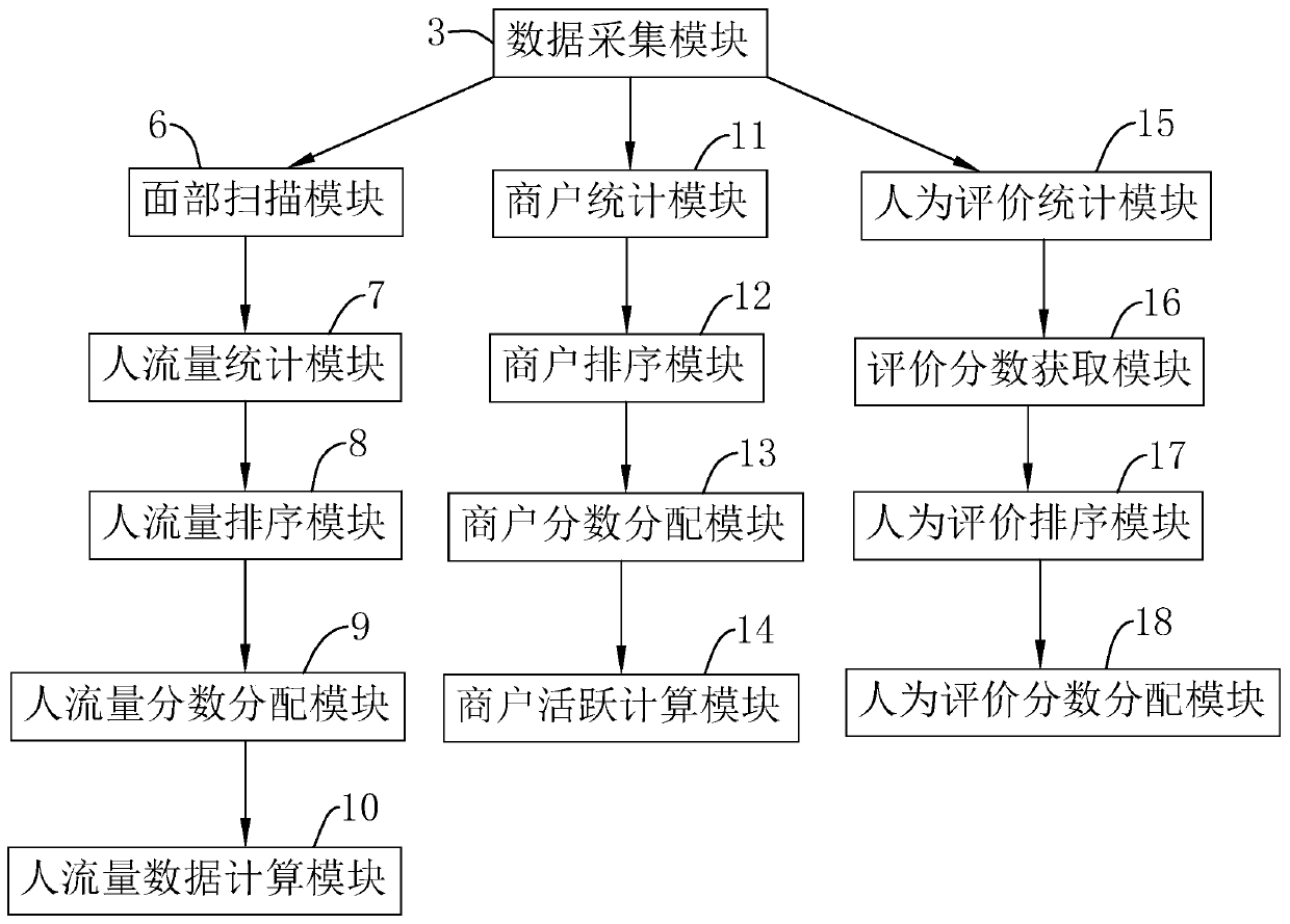
[0124] refer to figure 2 , a land value evaluation system, including a geographic location detection module 1, an evaluation area establishment module 2, a data collection module 3, a score conversion module 4 and an evaluation calculation module 5.

[0125] The geographic location detection module 1 is used to detect the geographical location of the land to be evaluated; the evaluation area establishment module 2 is coupled to the geographic location detection module 1 and establishes a value evaluation area with the same radius as the center of each land location to be evaluated. The radius of the evaluation area in the embodiment is preferably 100 meters; the data collection module 3 is coupled to the evaluation area establishment module 2 and collects merchant activity data, human evaluation data and the same week traffic data in the evaluation area; the score conversion module 4 is coupled In the data collection module 3, the collected merchant activity data, human evalu...


PUM


Abstract

The invention relates to a land value evaluation method and system. The method comprises the steps of obtaining geographic coordinate data of positions where a plurality of to-be-evaluated lands are located; taking the geographic coordinates of the land to be assessed as a circle center, and establishing corresponding assessment areas with the same radius; obtaining merchant active data, artificial evaluation data and pedestrian flow data of the same week in each evaluation area, and converting the merchant active data, the artificial evaluation data and the pedestrian flow data into corresponding score values based on a centesimal system; and calculating the scores of the corresponding to-be-assessed lands according to the pedestrian volume score accounting for 40%, the merchant activityscore accounting for 30% and the artificial assessment score accounting for 30%. The invention has the effect of improving the reference value of the to-be-assessed land.

Description

technical field [0001] The present invention relates to the technical field of land value evaluation, in particular to a land value evaluation method and system. Background technique [0002] The land value is the reference for the price of the development and auction land. The existing method of evaluating the land value is generally to use manual evaluation of the land value, and the method of manual evaluation of the land value is generally to use the market comparison method. The market comparison method is to compare the land to be evaluated with the The land price of the land that has been traded in the near future is compared, and the land value of the land to be evaluated is corrected based on the land price that has been traded. [0003] The above-mentioned existing technical solutions have the following defects: in the method of market comparison, the user needs to obtain the land price that has been traded in the near future, but different users have different exp...

Claims


Application Information

Patent Timeline
IPC IPC(8): G06Q30/02G06Q30/08G06Q50/16
CPCG06Q30/0201G06Q30/0278G06Q30/08G06Q50/165
Inventor 谢慧敏邓敏义秦治军
Owner 中冠工程管理咨询有限公司
Why Eureka
Try Eureka