Airplane segmentation method and device for remote sensing image, readable storage medium and equipment
A remote sensing image and aircraft technology, applied in computer parts, instruments, characters and pattern recognition, etc., can solve the problems of complex matching process and inaccurate results, and achieve accurate segmentation results, accurate segmentation results, and simple segmentation methods.
- Summary
- Abstract
- Description
- Claims
- Application Information
AI Technical Summary
Problems solved by technology
Method used
Image


Examples
Embodiment 1
[0075] The implementation of the present invention provides an aircraft segmentation method of a remote sensing image, and the aircraft segmentation refers to segmenting an aircraft on a remote sensing image. Such as figure 1 As shown, the method includes:
[0076] Step S100: Perform preprocessing including binarization on the remote sensing image, the preprocessed image includes multiple highlighted connected regions, and obtain aircraft candidate frames on the preprocessed image.
[0077] The preprocessed image is a binary image, and the binary image includes a plurality of highlighted connected regions. The aircraft candidate box is the initially determined rectangular area including the image of the aircraft.
[0078] Step S200: According to the proportion of connected areas in the aircraft candidate frame, find out the connected area where the aircraft is located and determine the shape of the aircraft included in the connected area where the aircraft is located. The sh...
example 1
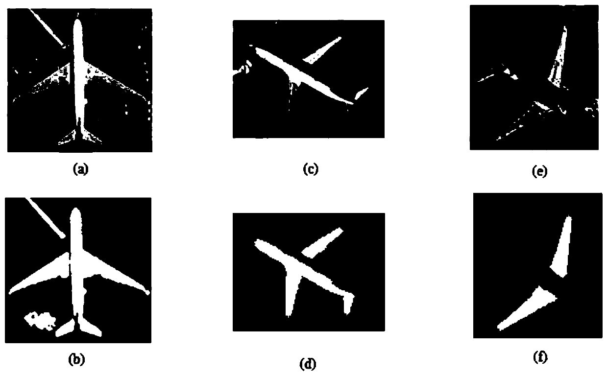
[0128] Step S310: Thinning the preprocessed image in the aircraft candidate frame into a skeleton map and expanding it into an edge map, and mixing the skeleton map and the edge map to obtain a mixed map.
[0129] In this step, the preprocessed image P of the aircraft is refined into a skeleton map P1, and the preprocessed image P of the aircraft is subjected to a morphological expansion operation to obtain an expanded edge map P2, and the above-mentioned skeleton map and edge map are combined to obtain a mixed map P ',in:
[0130] .
[0131] Such as Figure 4 As shown, (a) is a remote sensing image, (b) is a skeleton image, (c) is an edge image, and (d) is a mixed image.
[0132] It should be noted that the above-mentioned thinning process is performed on the preprocessed image P to obtain the skeleton map P1, the expansion operation is performed on the preprocessed image P to obtain the expanded edge map P2, and the skeleton map P1 and the edge map P2 are mixed. Obtaining...
example 2
[0158] Compared with Example 1, this example only uses the skeleton map and does not use the edge map.
[0159] Step S310': refine the preprocessed image in the aircraft candidate frame into a skeleton image.
[0160] Step S320': Perform straight line detection on the skeleton diagram to obtain multiple line segments, which are the center line segments of the fuselage and the center line segments of the wings.
[0161] Step S330': Merge the line segments that meet the merging conditions among the multiple line segments to obtain the inverted fuselage axis segment and the wing axis segment, which are the candidate line segments; where the acute angle between the two line segments to be merged is The angle is less than the set angle, and when the distance between the two line segments to be merged is less than the set distance, the merge condition is satisfied. The specific merge condition and merge method are as in Example 1.
[0162] Step S340': Find the candidate fuselage ax...
PUM
 Abstract
Description
Claims
Application Information