Rice refined yield estimation method based on sar and optical remote sensing data

An optical remote sensing, refined technology, applied in character and pattern recognition, reflection/re-radiation of radio waves, instruments, etc., can solve the problems of pixel spectral aliasing, affecting the accuracy of production estimation models, small block area, etc. Accurate yield estimation results, avoiding vegetation index errors, and improving estimation accuracy

Active Publication Date: 2020-12-01
北京四象爱数科技有限公司 +1
View PDF6 Cites 0 Cited by
  • Summary
  • Abstract
  • Description
  • Claims
  • Application Information

AI Technical Summary

Problems solved by technology

[0007] According to research results at home and abroad, although the use of medium and low resolution remote sensing data can play a good role in estimating the growth and yield of single or large areas of rice, due to the low resolution of remote sensing data, the phenomenon of pixel mixed spectrum is serious, especially In areas with complex planting structures, there is a certain deviation in the vegetation index value obtained through remote sensing, which restricts the improvement of the accuracy of rice yield estimation
At the same time, the rice production over the years released by the government is generally divided according to administrative regions, which is the statistical production in a large area, which will also affect the accuracy of the production estimation model
[0008] Moreover, in the southern and southwestern regions of my country, due to the constraints of the land contract system, the rice blocks planted by each farmer or cooperative are small and relatively scattered, and the real large-scale planting of single crops is rare, and the time span of rice planting by each farmer The difference between the growth stages of rice in the same region is obvious, and the low-resolution remote sensing yield estimation method makes the pixel spectra of different growth stages aliased seriously, resulting in the obtained vegetation index cannot accurately reflect the growth information of rice in each growth stage, and the yield estimation accuracy is even higher. difficult to achieve satisfactory results
Therefore, the traditional method of rice remote sensing yield estimation is not suitable for the fine application of this large-scale agricultural production

Method used


Image

  • Rice refined yield estimation method based on sar and optical remote sensing data
  • Rice refined yield estimation method based on sar and optical remote sensing data
  • Rice refined yield estimation method based on sar and optical remote sensing data

Examples


Embodiment

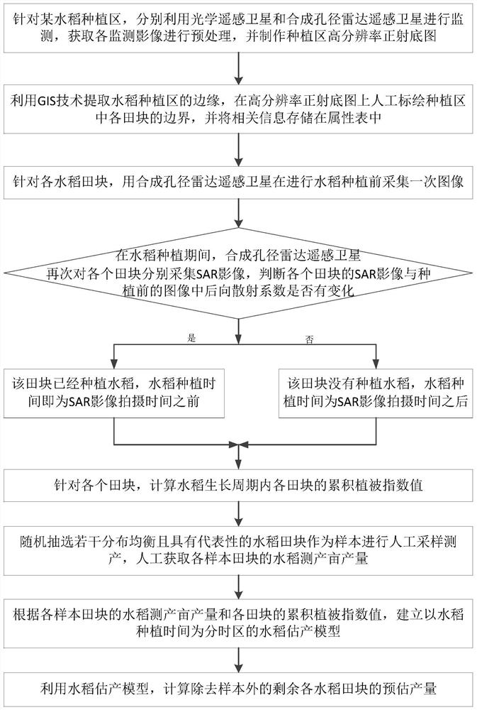
[0085] In the following, the 2019 rice income insurance project in a certain place in Sichuan is taken as an example to illustrate the rice remote sensing yield estimation method based on optical and SAR remote sensing data provided by the present invention.

[0086] According to the overall requirements and technical indicators of the project, collect basic data, mainly including optical satellite data, radar satellite data and related vector data, and perform remote sensing data preprocessing. Use the Gaofen-2 optical remote sensing satellite data to generate a remote sensing image orthophoto map of the work area with a resolution better than 1m. Based on this, interpret the rice field pattern in the GIS software and add relevant attribute information to the attribute table; Using the processed Sentinel-1 synthetic aperture radar data, combined with the microwave scattering characteristics of the water body, to perform threshold segmentation to obtain the rice planting time; ...


PUM


Abstract

The invention discloses a refined rice yield estimation method based on SAR and optical remote sensing data, which belongs to the field of agricultural application of remote sensing images. First, the optical remote sensing satellite is used to monitor the rice planting area, extract the edge of the rice planting area, and plot the boundaries of each field. Synthetic aperture radar remote sensing satellite was used to collect images before rice planting, and then SAR images were collected again for each field during rice planting, and the rice planting time was obtained according to the change of backscatter coefficient. Finally, for each field, calculate the cumulative vegetation index value ∑Max of each field during the rice growth cycle NDVI ; By randomly selecting paddy fields as samples, according to the yield per mu of the sample fields and the cumulative vegetation index value ∑Max of each field NDVI , establish a rice yield estimation model to measure yield, and use the verified rice yield estimation model to calculate the estimated yield of the remaining rice fields except the samples. The invention improves the estimation accuracy of rice yield per mu.

Description

technical field [0001] The invention belongs to the agricultural application field of remote sensing images, and in particular relates to a refined rice yield estimation method based on SAR (Synthetic Aperture Radar, synthetic aperture radar) and optical remote sensing data. Background technique [0002] Rice is one of the crops with the longest history in my country. Its planting history can be traced back to the Neolithic Age 7,000 years ago. It is one of the important food crops in my country and occupies a very important position in the entire agriculture and even the national economy. According to the Statistical Bulletin on National Economic and Social Development in 2010, the rice planting area in my country is 30.19 million hectares, accounting for 25.8% of the total grain planting area in the country, and its output is 212.13 million tons, reaching 32.2% of the total grain production in the country. [0003] The monitoring of rice planting area and the accurate estim...

Claims


Application Information

Patent Timeline
Patent Type & Authority Patents(China)
IPC IPC(8): G06K9/00G01S13/90
CPCG01S13/90G06V20/188G01S13/9027
Inventor 俞雷张薇侯从强郗晓菲姚勇航康曼张书毅
Owner 北京四象爱数科技有限公司
Why Eureka
Try Eureka