
Positioning calculation method and device and satellite navigation receiver

A technology for positioning calculation and satellite navigation, which is applied in the fields of satellite navigation receivers, positioning calculations, computer-readable storage media, and positioning calculation devices, and can solve problems such as low positioning accuracy

Active Publication Date: 2020-07-07
TECHTOTOP MICROELECTRONICS
View PDF11 Cites 0 Cited by
  • Summary
  • Abstract
  • Description
  • Claims
  • Application Information

AI Technical Summary

Problems solved by technology

[0005] In view of this, the embodiment of the present invention provides a positioning solution method, device and satellite navigation receiver to solve the problem of low positioning accuracy in satellite navigation positioning in the prior art

Method used


Image

  • Positioning calculation method and device and satellite navigation receiver
  • Positioning calculation method and device and satellite navigation receiver
  • Positioning calculation method and device and satellite navigation receiver

Examples


Embodiment Construction

[0029] In the following description, specific details such as specific system structures and technologies are presented for the purpose of illustration rather than limitation, so as to thoroughly understand the embodiments of the present invention. It will be apparent, however, to one skilled in the art that the invention may be practiced in other embodiments without these specific details. In other instances, detailed descriptions of well-known systems, devices, circuits, and methods are omitted so as not to obscure the description of the present invention with unnecessary detail.

[0030] The technical solutions of the present invention are illustrated below through specific examples.

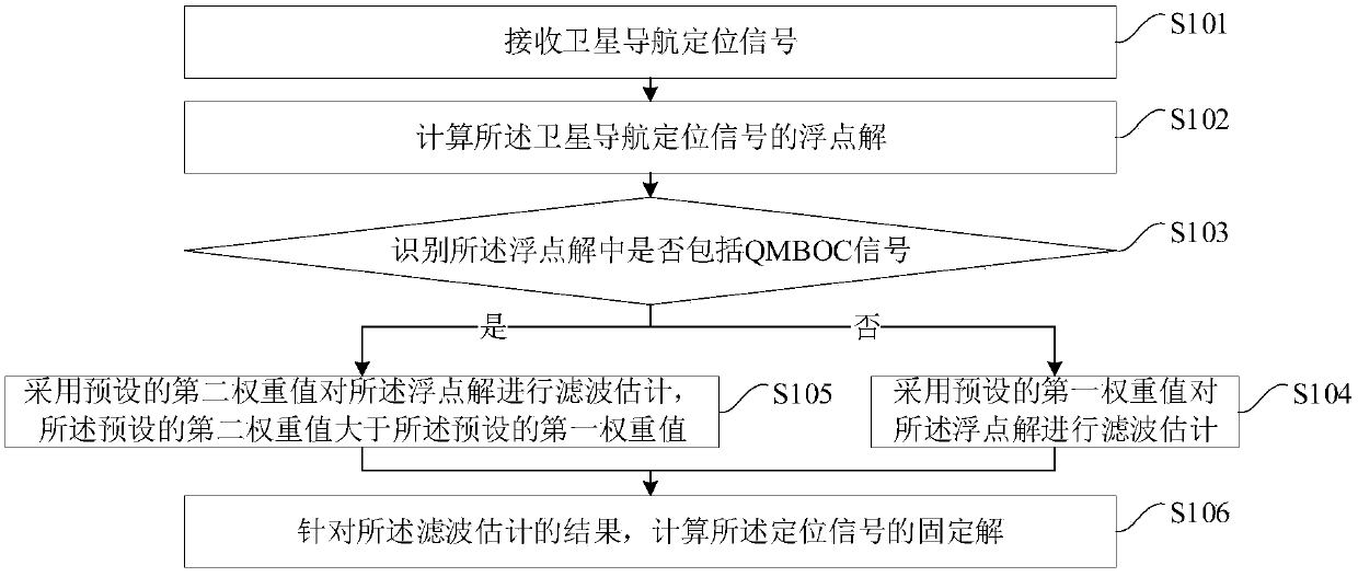
[0031] In satellite navigation and positioning, in order to provide better interoperability with other systems, the civilian signal B1C of Beidou satellite navigation system adopts QMBOC technology in the design process, which can not only meet the requirements of radio frequency compatibilit...


PUM


Abstract

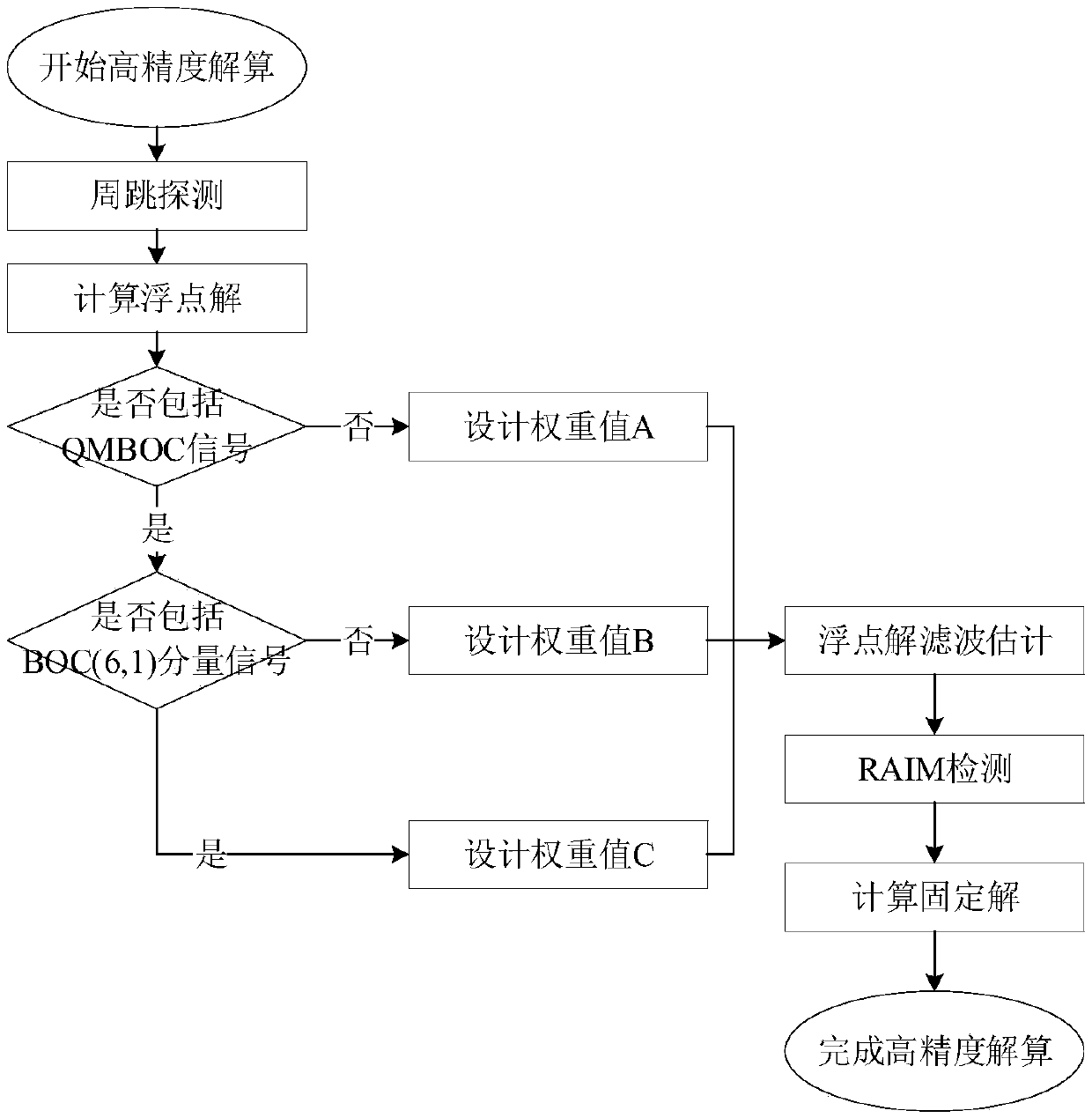
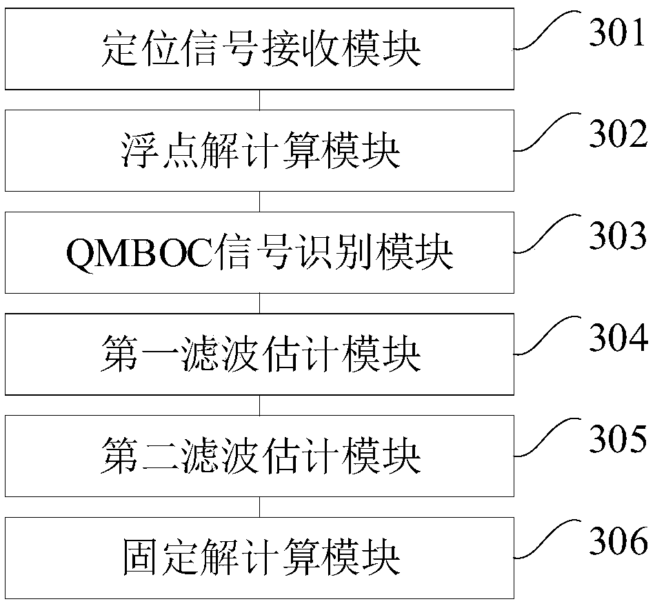
The embodiment of the invention is applicable to the technical field of positioning, and provides a positioning calculation method and device and a satellite navigation receiver. The method includes receiving a satellite navigation positioning signal; calculating a floating point solution of the satellite navigation positioning signal; identifying whether the floating point solution comprises a QMBOC signal or not; if the floating point solution does not include the QMBOC signal, performing filtering estimation on the floating point solution by adopting a preset first weight value; if the floating point solution comprises the QMBOC signal, adopting a preset second weight value to carry out filtering estimation on the floating point solution, and the preset second weight value is larger than the preset first weight value; and calculating a fixed solution of the positioning signal according to a result of the filtering estimation. According to the embodiment, the characteristics of the QMBOC signals can be utilized, high-precision calculation is achieved, and the positioning precision and accuracy are improved.

Description

technical field [0001] The invention belongs to the technical field of positioning, and in particular relates to a positioning calculation method, a positioning calculation device, a satellite navigation receiver and a computer-readable storage medium. Background technique [0002] BeiDou Navigation Satellite System (BDS for short) is a global satellite navigation system independently developed by my country. The Beidou satellite navigation system consists of three parts: the space segment, the ground segment and the user segment. It can provide high-precision, high-reliability positioning, navigation, and timing services for various users around the clock and around the world. [0003] When the Beidou satellite navigation system is used for positioning, the satellite signal can be received by the satellite navigation receiver and undergo a series of processing to complete the positioning. Usually, a satellite navigation receiver is composed of three parts: radio frequency ...

Claims


Application Information

Patent Timeline
Patent Type & Authority Applications(China)
IPC IPC(8): G01S19/44G01S19/37
CPCG01S19/44G01S19/37
Inventor 元荣高峰许祥滨
Owner TECHTOTOP MICROELECTRONICS
Learn More