Eureka AIR delivers breakthrough ideas for toughest innovation challenges, trusted by R&D personnel around the world.

Electronic map display method, terminal and electronic equipment

An electronic map and geographic technology, applied in the electronic field, can solve problems such as limited information, failure to meet user needs, and single form

Pending Publication Date: 2020-07-07
西安四维图新信息技术有限公司
View PDF2 Cites 0 Cited by
  • Summary
  • Abstract
  • Description
  • Claims
  • Application Information

AI Technical Summary

Problems solved by technology

[0004] However, the information contained in paper maps or electronic pictures is limited and in a single form, which cannot meet the needs of users

Method used


Image

  • Electronic map display method, terminal and electronic equipment
  • Electronic map display method, terminal and electronic equipment
  • Electronic map display method, terminal and electronic equipment

Examples


Embodiment Construction

[0033] In order to make the purpose, technical solutions and advantages of the embodiments of the present invention clearer, the technical solutions in the embodiments of the present invention will be clearly and completely described below in conjunction with the drawings in the embodiments of the present invention. Obviously, the described embodiments It is a part of embodiments of the present invention, but not all embodiments. Based on the embodiments of the present invention, all other embodiments obtained by persons of ordinary skill in the art without creative efforts fall within the protection scope of the present invention.

[0034] The "plurality" referred to herein refers to two or more than two. "And / or" describes the association relationship of associated objects, indicating that there may be three types of relationships, for example, A and / or B may indicate: A exists alone, A and B exist simultaneously, and B exists independently. The character " / " generally indi...


PUM


Abstract

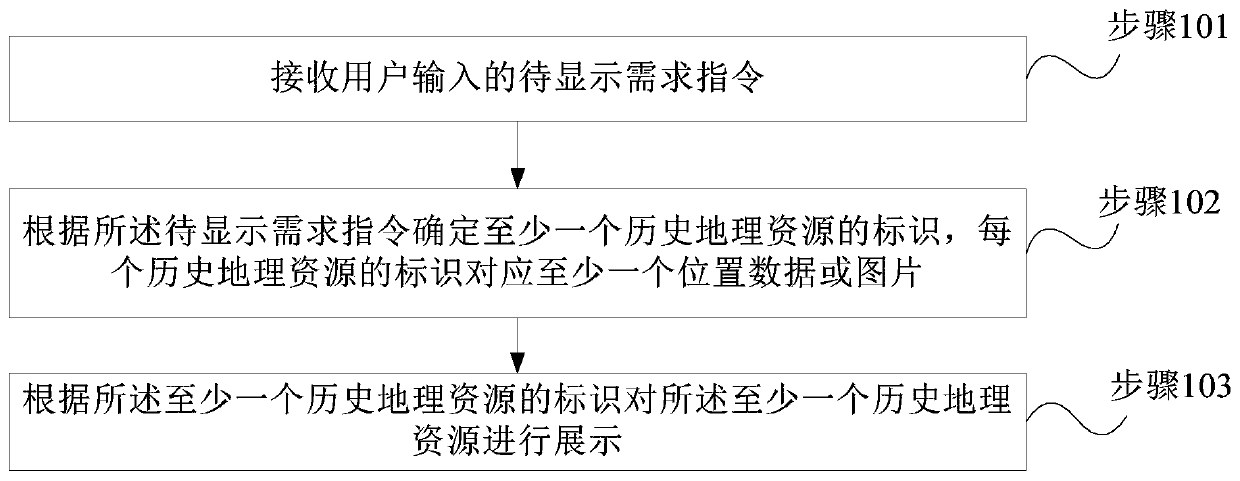
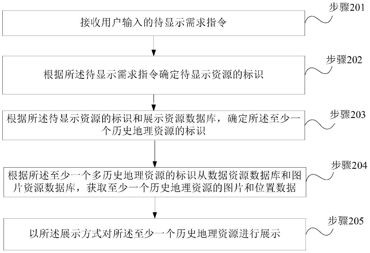
An embodiment of the invention provides an electronic map display method, a terminal and electronic equipment. The electronic map display method comprises the steps of: receiving a to-be-displayed demand instruction input by a user, wherein the to-be-displayed demand instruction is used for triggering display of at least one of pictures and position data of historical geographic resources; determining an identifier of at least one historical geographic resource according to the to-be-displayed demand instruction, wherein the identifier of each historical geographic resource corresponds to at least one piece of position data or pictures; and displaying the at least one historical geographic resource according to the identifier of the at least one historical geographic resource, wherein thepictures and the position data of the historical geographic resources are obtained by matching and adjusting original pictures and original data of the historical geographic resources by using an electronic map coordinate system. According to the electronic map display method of the invention, the effective display of the territory changes or other changes of the history can be achieved, the display becomes more vivid and clearer, and the application range of an electronic map is enlarged.

Description

technical field [0001] Embodiments of the present invention relate to electronic technology, and in particular to a method for displaying an electronic map, a terminal and electronic equipment. Background technique [0002] A map is a graphic that uses lines, symbols, colors, text notes, etc. to depict and display the physical geography, administrative regions, and social conditions of the earth's surface in a certain proportion. It uses the map language, and through cartographic synthesis, it is narrowed and reflected on the plane, reflecting the spatial distribution, combination, connection, quantity and quality characteristics of various phenomena and their development and changes over time. [0003] Maps are classified according to storage media, which may include paper maps, film maps, silk maps, magnetic media maps (CD maps, electronic maps), etc. It can be applied in teaching and other fields. In the field of teaching, paper maps or electronic pictures are usually u...

Claims


Application Information

Patent Timeline
IPC IPC(8): G06F16/29
Inventor 仵志强刘芬徐颖
Owner 西安四维图新信息技术有限公司
Why Eureka
Eureka Blog
Learn More