Electronic map local display method and device

An electronic map and display method technology, applied in the directions of map/plan/chart, graphic image conversion, image data processing, etc., can solve the problem of inconvenient observation of map information, etc., and achieve the effect of convenient and quick map query operation

Active Publication Date: 2020-07-14
ALIBABA GRP HLDG LTD
View PDF6 Cites 3 Cited by
  • Summary
  • Abstract
  • Description
  • Claims
  • Application Information

AI Technical Summary

Problems solved by technology

For this reason, the user can only constantly switch between the global mode and the local mode by zooming in and out, and temporarily remember and associate the information seen in the two modes in his mind to obtain the information he needs. It is convenient for users to observe map information intuitively

Method used


Image

  • Electronic map local display method and device
  • Electronic map local display method and device
  • Electronic map local display method and device

Examples


Embodiment 1

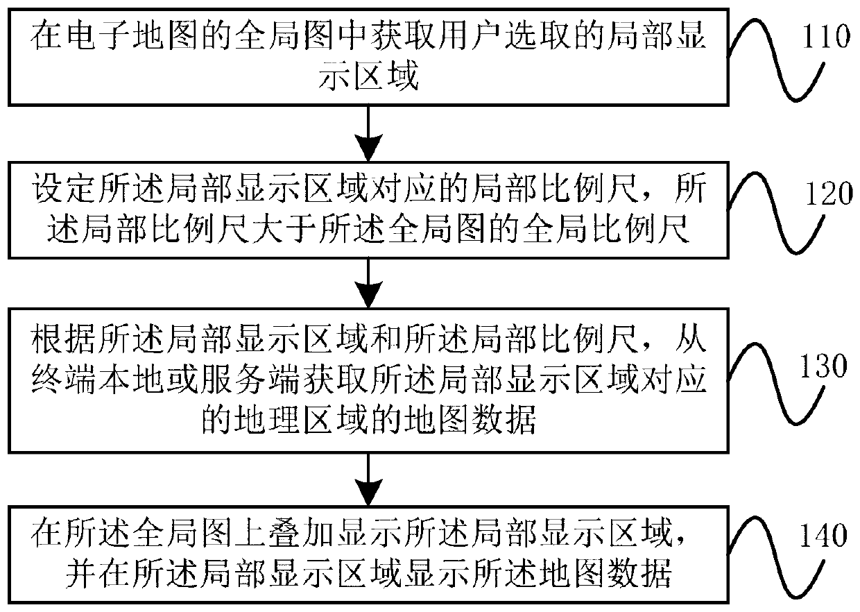
[0030] figure 1 The electronic map partial display method provided by Embodiment 1 of the present invention, as shown in the figure, includes the following steps:

[0031] Step 110, acquiring the local display area selected by the user in the global map of the electronic map.

[0032] Wherein, the global map refers to the entire screen of the electronic map when no partial display is performed. The local display area refers to the area selected by the user of the electronic map in the global map of the electronic map for partial display.

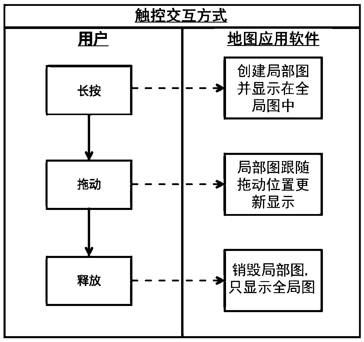
[0033] Specifically, the map point input by the user in the global map may be acquired, and a local display area of ​​a preset shape and size may be generated centered on the map point. For example, it can be acquired by clicking. Wherein, the clicking means that the user selects a map point in the global map. Specifically, the user can touch a certain point in the global map for a long time with a finger or a handwriting tool, or double-...

Embodiment 2

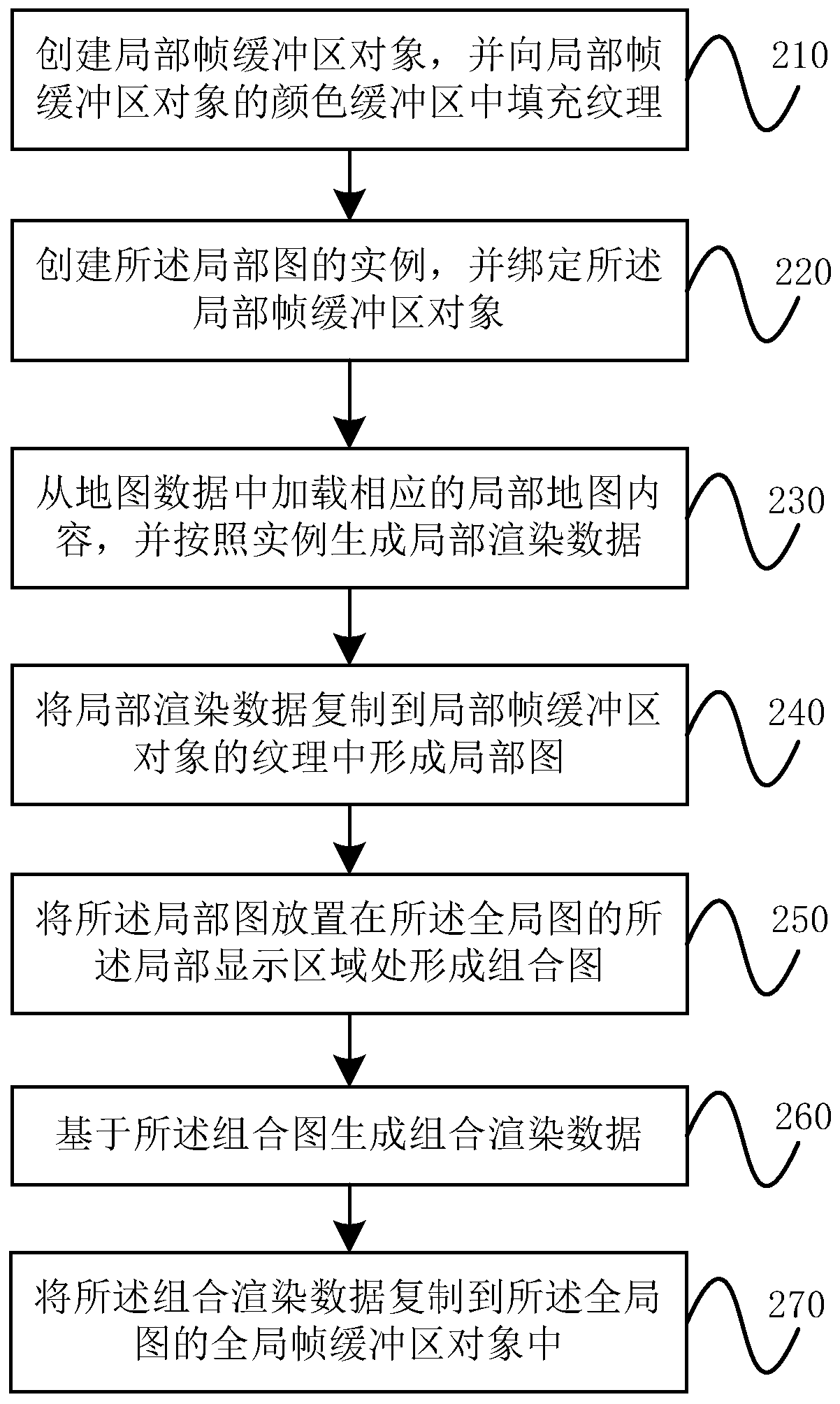
[0047] This embodiment specifically introduces the implementation of displaying map data in the local display area in the above step 130, such as image 3 shown, including the following steps:

[0048] Step 210, create a local frame buffer object, and fill the texture into the color buffer of the local frame buffer object.

[0049] The frame buffer is a storage space for storing rendering data processed or to be extracted by the graphics card chip. The frame buffer object (Frame Buffer Object, FBO for short) includes multiple frame buffers, such as a color buffer, a depth buffer, a template buffer, and the like. Among them, two types of data can be filled in the color buffer: one is texture data, which is used to copy rendering data to it; the other is buffer data, which is used to fill when the color buffer is not needed. The local framebuffer object is a framebuffer object for generating a partial image.

[0050] Step 220, create an instance of the partial graph, and bind...

Embodiment 3

[0065] This embodiment provides a partial display device for an electronic map, which can implement the above method, such as Figure 5 As shown, it includes: an area acquisition module 11, a ratio setting module 12, a data acquisition module 13 and an overlay display module 14, and its working principle is as follows:

[0066] The area acquisition module 11 acquires the local display area selected by the user in the global map of the electronic map. Specifically, the map point input by the user in the global map can be obtained, and a local display area with a preset shape and size can be generated centering on the map point; or, the user can also obtain the The closed area input in the global map of the map is used as the local display area.

[0067] Then, the local scale corresponding to the local display area is set by the scale setting module 12, and the local scale can be larger or smaller than the global scale of the global map; specifically, the global scale of the gl...


PUM


Abstract

The invention discloses an electronic map local display method and device. The method comprises: obtaining a local display area selected by a user from a global map of an electronic map; setting a local scale corresponding to the local display area, wherein the local scale is greater than the global scale of the global graph; acquiring map data of a geographic area corresponding to the local display area from a local terminal or a server according to the local display area and the local scale; and displaying the local display area on the global graph in an overlapping manner, and displaying the map data in the local display area. According to the invention, the display effect of simultaneously displaying the global picture and the local picture of the electronic map on the same display picture is realized, so that the map query operation is more convenient and faster.

Description

technical field [0001] The invention relates to a partial display method and device of an electronic map, belonging to the technical field of electronic maps. Background technique [0002] Existing electronic maps usually adopt a hierarchical display method, and each level represents a different scale, displays data of different granularities, and displays different information. For example, at a small scale, you can view overview information, such as road direction, etc.; at a large scale, you can view detailed information of a specific point, such as the location of a building. [0003] The defect of the existing technology is that the existing electronic map can only display one level of map screen at a certain moment, and at this time, the user can only obtain the information displayed at this level. If you want to view local detailed information, you can only zoom in on the map screen as a whole; if you want to view global overview information, you can only zoom out th...

Claims


Application Information

Patent Timeline
Patent Type & Authority Applications(China)
IPC IPC(8): G06F3/0481G06F3/0484G06T3/40G09B29/10
CPCG06F3/0481G06F3/04845G06T3/40G09B29/10
Inventor 王海鹏王前卫
Owner ALIBABA GRP HLDG LTD
Why Eureka
Try Eureka