
Star map display method taking all-sky imaging as background

An all-sky imaging and display method technology, applied in the field of star map recognition, can solve problems such as inability to accurately judge, increase the difficulty of finding stars, and fail to find stars, and achieve the effects of improving observation efficiency, reducing the difficulty of finding stars, and improving work efficiency.

Active Publication Date: 2020-08-14
CHANGCHUN INST OF OPTICS FINE MECHANICS & PHYSICS CHINESE ACAD OF SCI
View PDF11 Cites 0 Cited by
  • Summary
  • Abstract
  • Description
  • Claims
  • Application Information

AI Technical Summary

Problems solved by technology

[0003] In order to solve the problem that the existing star map display method cannot accurately judge whether the star search fails due to the wrong search position or other complex sky environment interference factors such as obstructions, resulting in increased difficulty in star search, the present invention provides a comprehensive Star map display method with sky image as background

Method used


Image

  • Star map display method taking all-sky imaging as background
  • Star map display method taking all-sky imaging as background
  • Star map display method taking all-sky imaging as background

Examples


specific Embodiment approach 1

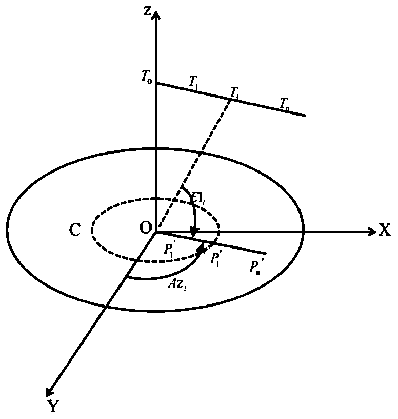
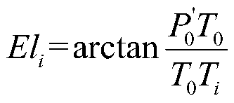
[0012] Specific implementation mode 1. Combination figure 1 and figure 2 Describe this embodiment, a method for displaying a star map with full-sky imaging as the background,

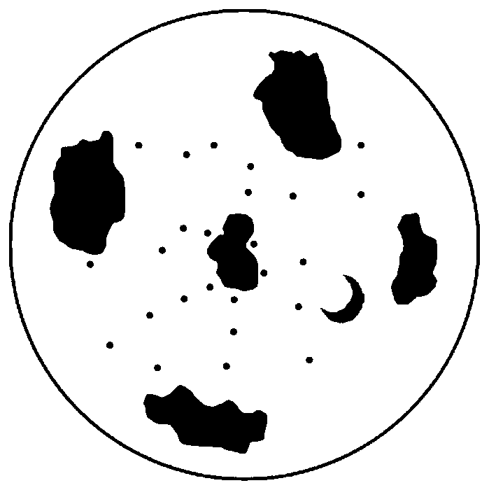
[0013] The whole-sky imaging map is obtained by shooting with a fisheye camera. The shape of the whole-sky imaging map is also circular. The size, shape, and position of clouds, stars, moon, and sun on the map are formed by the actual image projection on the horizon coordinates. , this projection principle is similar to the projection method of converting equatorial coordinates to horizon coordinates when forming a star map. The azimuth angle and altitude angle of the target in the whole-sky imaging map are consistent with the definition in the horizon coordinate system, but because the whole-sky imaging map is composed of The camera captures it, so when projecting, there is a certain deviation between the distance between the stars in the all-sky imaging map and the center of the map circle and the d...


PUM


Abstract

The invention discloses a star map display method taking all-sky imaging as a background, relates to the technical field of star map identification, and solves the problems that an existing star map display method cannot accurately judge whether star finding fails due to other complex sky environment interference factors such as wrong finding position or shielding of a shielding object or not andthus the difficulty of star finding is increased. According to the method, dynamic sky imaging of a visible sky area serves as a background, a star map is displayed on the background, and sky information display and star map display can be provided at the same time. According to the display method, sky background information and star map information are integrated, the conditions of different skyareas can be known in time while the star map is used, a user is helped to master more observation information, an observation strategy can be adjusted in real time according to the conditions such asthe cloud amount and the light, and thus the observation efficiency is improved.

Description

technical field [0001] The present invention relates to the technical field of star map recognition, in particular to a star map display method based on whole-sky imaging, which is applicable to any scene that needs to use the star map to identify and identify stars. Background technique [0002] The star map is an important tool for identifying stars and indicating the position of stars. The traditional star map is formed by projecting the spherical apparent position of the stars on the plane, that is, by converting the equatorial coordinates of the stars into horizontal coordinates, and by equal proportion Zoom out and display in a circular area, which in turn shows the position, brightness and shape of the star. When people use the traditional star map, the star map can only provide the position information of the star. In the process of star search, it is impossible to accurately judge whether the star search failed due to other complex sky environment interference facto...

Claims


Application Information

Patent Timeline
Patent Type & Authority Applications(China)
IPC IPC(8): G01C21/02
CPCG01C21/02Y02A90/10
Inventor 王昊京刘佳梁
Owner CHANGCHUN INST OF OPTICS FINE MECHANICS & PHYSICS CHINESE ACAD OF SCI
Learn More