
Dynamic tracking display method, terminal and storage medium

A technology of dynamic tracking and display methods, applied in image data processing, structured data retrieval, instruments, etc., can solve the problem of inability to distinguish whether all GPS mobile terminals are on the same screen, have large latitude and longitude or offset, and cannot obtain timely location information etc.

Pending Publication Date: 2020-08-18
GENEW TECH
View PDF2 Cites 0 Cited by
  • Summary
  • Abstract
  • Description
  • Claims
  • Application Information

AI Technical Summary

Problems solved by technology

[0003] The disadvantage of this tracking display method is that when individual GPS mobile terminals are located far away, after zooming out on the map, some GPS mobile terminals with relatively close distances will be stacked together, and it is impossible to tell whether all GPS mobile terminals are in the same location. On one screen; when the

Method used


Image

  • Dynamic tracking display method, terminal and storage medium
  • Dynamic tracking display method, terminal and storage medium
  • Dynamic tracking display method, terminal and storage medium

Examples


Embodiment 1

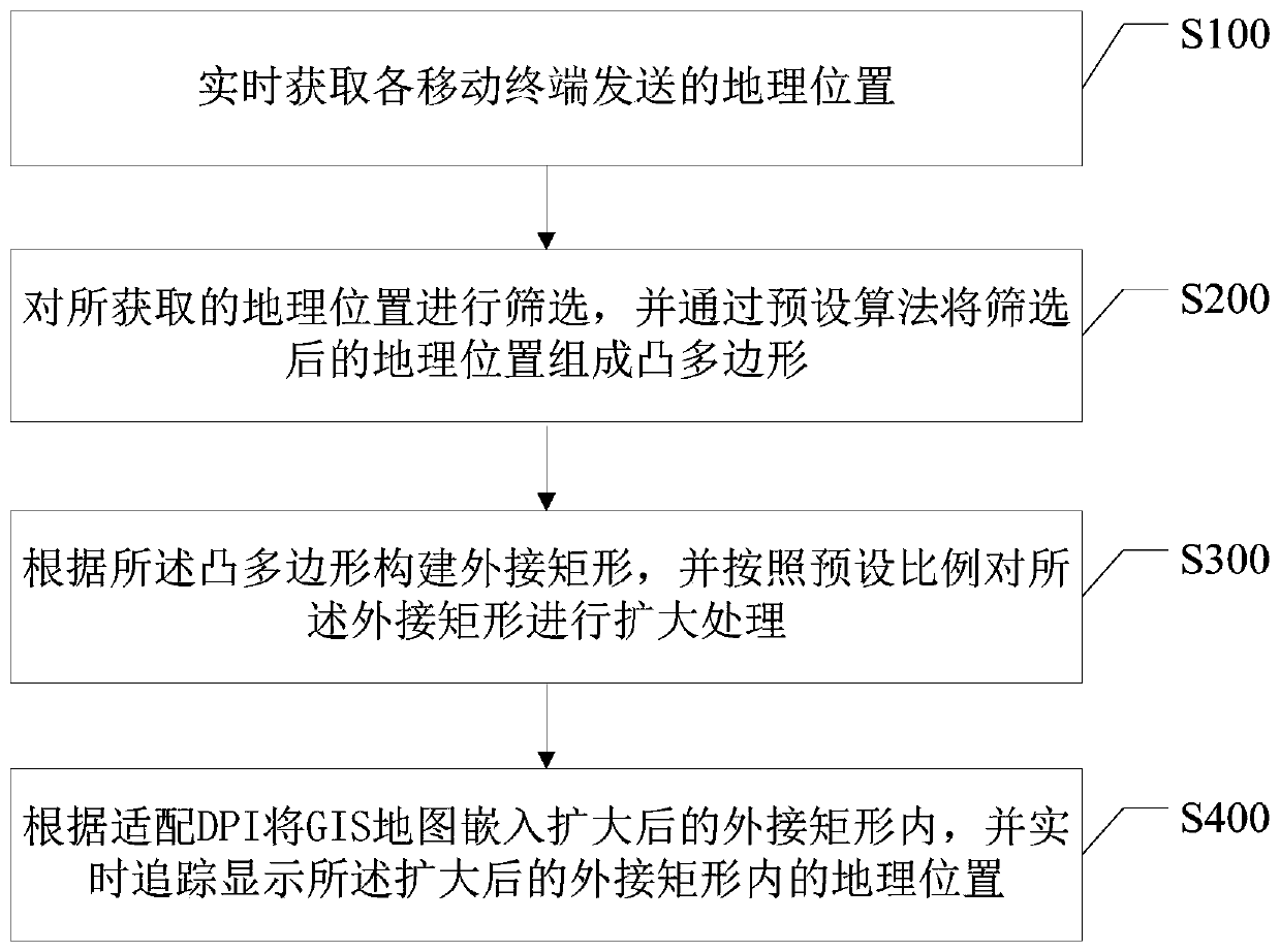
[0049] In the traditional tracking and positioning method, for the positioning of multiple mobile terminals, it is necessary to reduce the map to the level where all mobile terminals can be seen, and then adjust the visible area of ​​the map; since the map is reduced as much as possible, the distance The position points of the closer mobile terminals are superimposed on each other, and the number of tracked mobile terminals cannot be known exactly, and the exact position of each mobile terminal cannot be known exactly.

[0050] In order to present the optimal display angle of view of multiple tracking point locations and accurately display the geographic locations of multiple tracking points, this embodiment provides a dynamic tracking display method, which is applied to a terminal, and the terminal includes But not limited to: devices such as mobile terminals, tablets and computers.

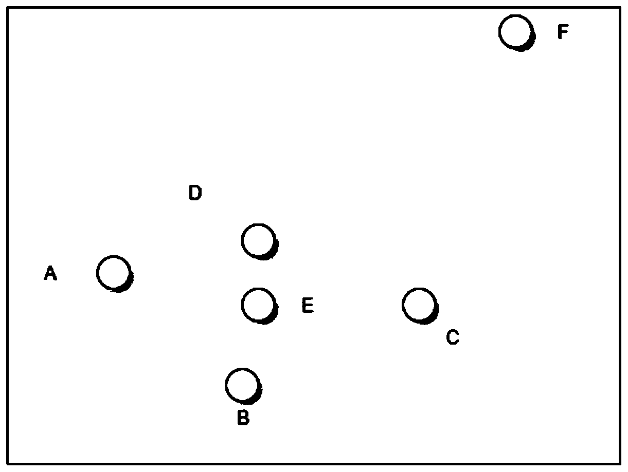
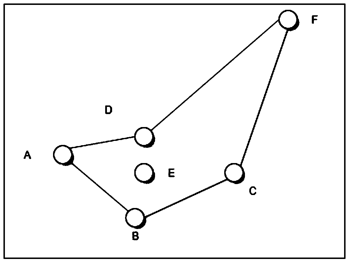
[0051] Such as figure 1 As shown, in an implementation of this embodiment, the dynamic trac...

Embodiment 2

[0121] Such as Figure 8 As shown, this embodiment provides a terminal, which includes a processor 10, and a memory 20 connected to the processor 10, the memory 20 stores a dynamic tracking display program, and the dynamic tracking display program is used by the When executed, the processor 10 is used to implement the operations of the dynamic tracking and display method described in the first embodiment; the details are as described above.

Embodiment 3

[0123] This embodiment provides a storage medium, wherein the storage medium stores a dynamic tracking display program, and when the dynamic tracking display program is executed by a processor, it is used to realize the operation of the dynamic tracking display method as described in Embodiment 1; Specifically as above.

[0124] In summary, the present invention screens according to the latitude and longitude of the geographic location sent by each mobile terminal, and removes the geographic location that does not meet the latitude and longitude standard; and constructs a convex polygon and a corresponding circumscribed rectangle according to the convex hull algorithm, and embeds the GIS map into the enlarged In the circumscribed rectangle, multiple dynamic moving positions can be presented with the best viewing angle, and the function of dynamic tracking can be realized.


PUM


Abstract

The invention discloses a dynamic tracking display method, a terminal and a storage medium. The dynamic tracking display method comprises the following steps: acquiring a geographic position sent by each mobile terminal in real time; screening the acquired geographic positions, and forming a convex polygon by the screened geographic positions through a preset algorithm; constructing an external rectangle according to the convex polygon, and expanding the external rectangle according to a preset proportion; and embedding the GIS map into the expanded external rectangle according to the adaptiveDPI, and tracking and displaying the geographic position in the expanded external rectangle in real time. The dynamic tracking display method carries out screening according to the longitude and latitude of the geographic position sent by each mobile terminal to remove the geographic position which does not meet the longitude and latitude standard, constructs a convex polygon and a correspondingcircumscribed rectangle according to a convex hull algorithm, and embeds the GIS map into the expanded circumscribed rectangle, so that a plurality of dynamic moving positions are presented at an optimal visual angle, and a dynamic tracking function is realized.

Description

technical field [0001] The present invention relates to the field of terminal applications, in particular to a dynamic tracking display method, a terminal and a storage medium. Background technique [0002] On the large screen of emergency dispatch command, it is often necessary to track the positions of multiple GPS mobile terminals in real time on the GIS map; the traditional tracking display method is: first reduce the map to the level where all GPS mobile terminals can be seen, and then The movement of the GPS mobile terminal can adjust the visible area of ​​the map at any time. [0003] The disadvantage of this tracking display method is that when individual GPS mobile terminals are located far away, after zooming out on the map, some GPS mobile terminals with relatively close distances will be stacked together, and it is impossible to tell whether all GPS mobile terminals are at the same location. On one screen; when the GPS mobile terminals constantly change their po...

Claims


Application Information

Patent Timeline
IPC IPC(8): G06F16/29G06T11/20G01S19/14
CPCG06F16/29G06T11/203G01S19/14Y02D10/00
Inventor 陈志芬卫宣安姜坤吴闽华
Owner GENEW TECH
Features
  • Generate Ideas
  • Intellectual Property
  • Life Sciences
  • Materials
  • Tech Scout
  • Unparalleled Data Quality
  • Higher Quality Content
  • 60% Fewer Hallucinations
Learn More