Proximate location detection system and method

a detection system and location technology, applied in the direction of navigation instruments, instruments, assess restrictions, etc., can solve the problems of more sensitive and expensive implementation of such systems in commercial environments

Inactive Publication Date: 2006-12-21
SMART INTERNET TECH CRC
View PDF6 Cites 97 Cited by
  • Summary
  • Abstract
  • Description
  • Claims
  • Application Information

AI Technical Summary

Benefits of technology

[0044] In its first aspect, the present invention offers the advantage of providing only the user of the system, a person with such mobile location indicating device, with their proximate location which cannot be tracked or recorded by a third party unless offered by the person. At best, only the general geographical area in which the person is located could be determined by a third party, eg where the step of determining the geographical area comprises the use of a GSM network to download high-level location and geographical area data and map information. However, the person's movements in said geographic area cannot be tracked until the person requests further information specific to a particular location.
[0046] From a viewpoint of a user, the invention provides, in its different aspects, a secure way of determining the proximate location of a user within a given broader / larger area as well as the option of receiving information about services / goods (or other type of information) of providers located in that area without divulging / giving away the user's fine grained position to any third party.
[0047] It will be appreciated that the invention's system and methods are devised to provide flexible indoor and outdoor location management schemes. The system is set-up to allow only the end user to be aware of their location while indoors, rather than provide a system which actively tracks the user. With such system, the end-user may provide or publish, on varying levels of granularity, their location details thus enabling information or group services to be actively downloaded by or passively pushed into an appropriate application tool of the mobile location indicating device.
[0052] Thus a scalable delivery and data encoding mechanism for both the location mapping and location-tied data is provided. The invention's system integrates the approximate network location technologies currently available with low-cost, localised location-awareness. Typically, a handset-resident application will query the GSM network for its approximate location, which will then trigger the delivery of high-level mapping, local information and existing local wireless network information, which may be referred to as MIW (Mapping, Information, Wireless) data.

Problems solved by technology

Consequently, security measures have to be implemented to prevent unauthorized access to the information, which makes implementation of such systems in a commercial environment more expensive and sensitive to run.

Method used


Image

  • Proximate location detection system and method
  • Proximate location detection system and method
  • Proximate location detection system and method

Examples


Embodiment Construction

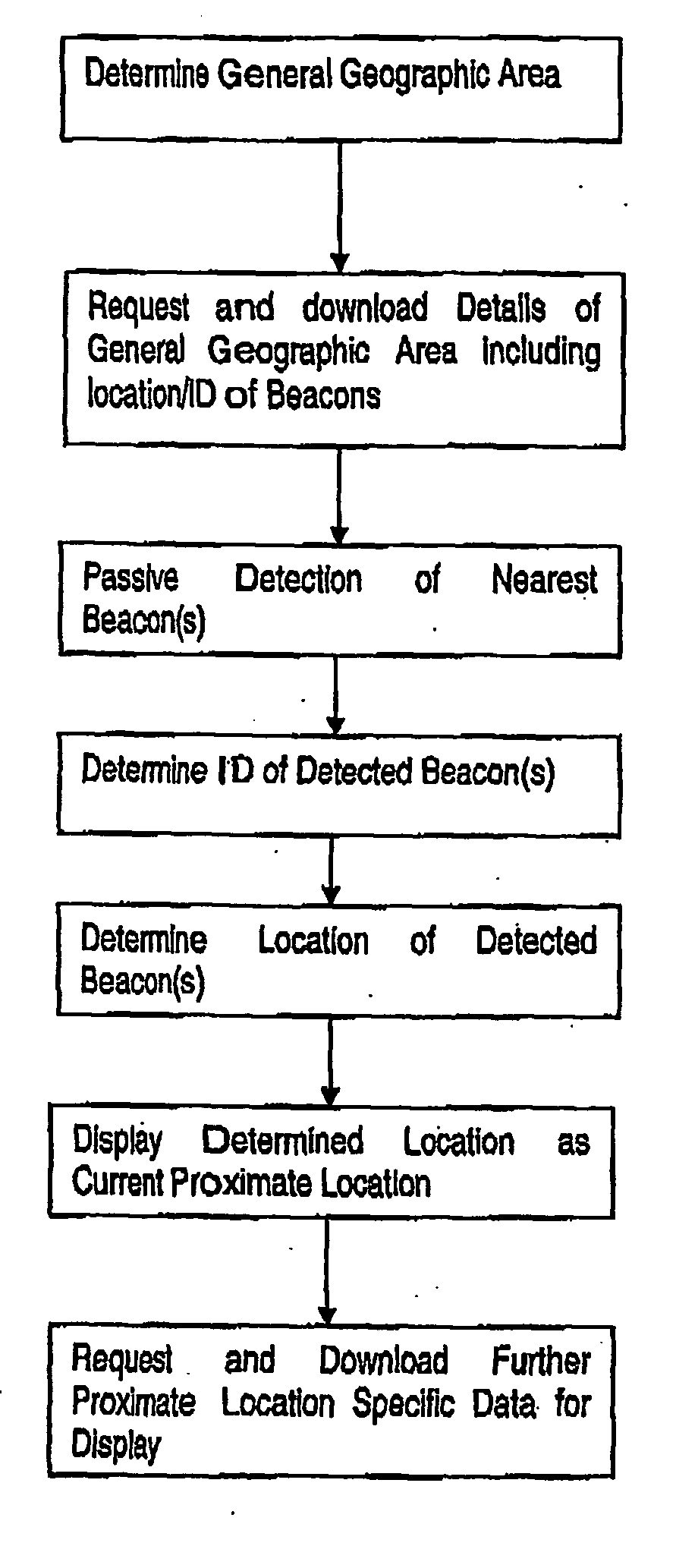
[0058] The aspect of the present invention that allows a user to determine his / her location (to an acceptable degree of resolution) within a general geographical area will be described by way of example in a specific implementation with reference to the flowchart of FIG. 1.

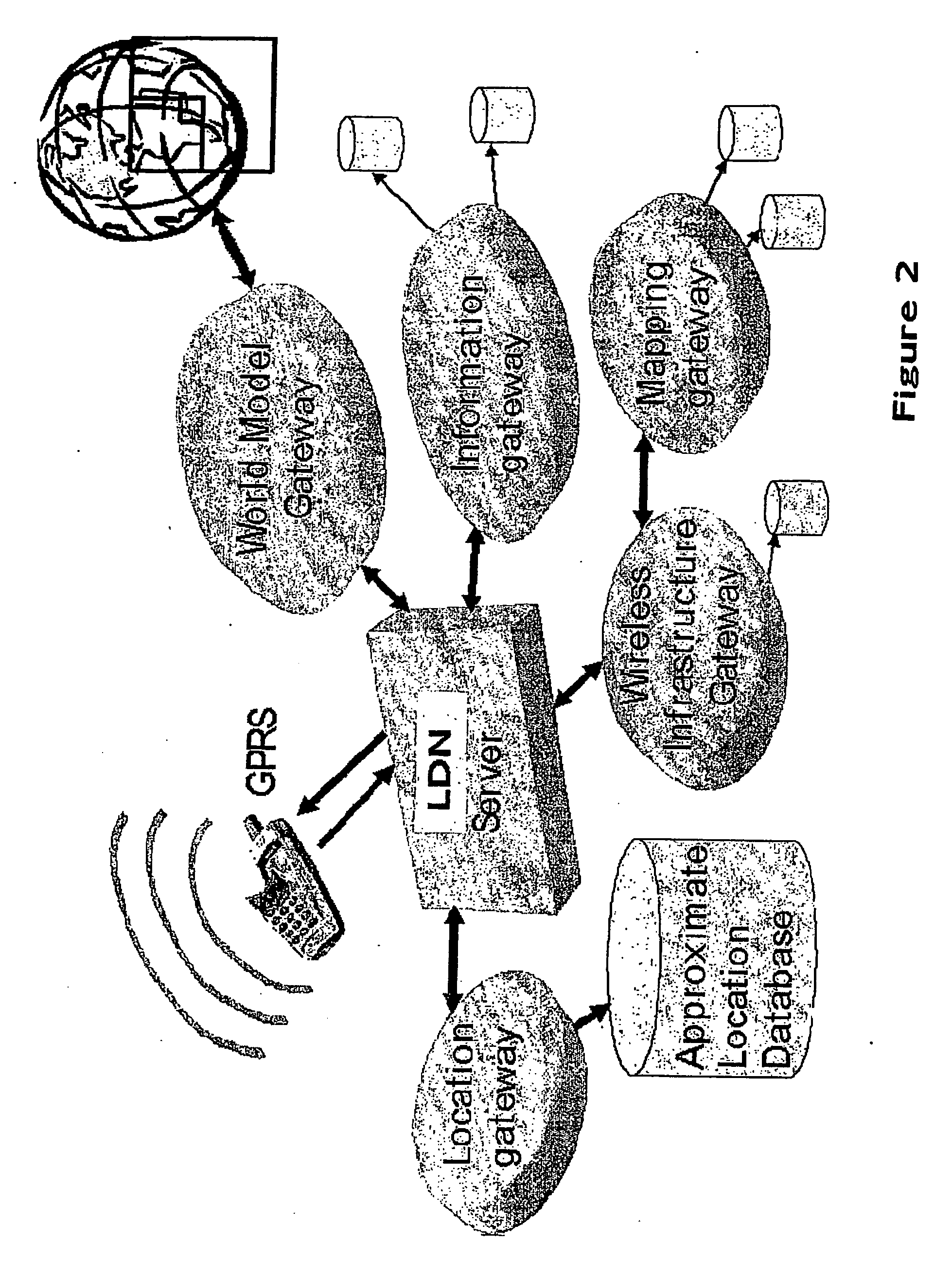
[0059] From a system point of view, the hardware of which is described below with reference to FIG. 2, the user initially needs to determine the general geographic area in which he / she is presently located. The user's mobile location indicating device is, in a preferred form of the invention, incorporated in a cellular mobile handset. Therefore, the general geographic area may be readily determined in a known manner by identifying the nearest base station of the mobile telephony network. It will be appreciated that a cellular base station is intended to cover a particular geographic area, i.e., its cell area, typically the cell area is an area of approximately 500 square meters. Thus this cell area will be taken ...


PUM


Abstract

A proximate location detection system and method is provided. A user carries a mobile location indicating device which initially determines the general geographic area in which the device is located. The device is able to download map data in relation to the general geographic area, the map data comprises details of beacons and their locations within the general geographic area. The device is then able to passively detect and identify beacons within its physical proximity. The identity of the detected beacons is then compared with the downloaded data to determine their location which is then displayed to the user as their proximate location within the general geographic area. Hence, the user can approximately track their own movements within a large area without third parties being able to determine the user's location within the large area.

Description

CROSS-REFERENCE TO RELATED APPLICATION [0001] This application is a continuation application of International Application No. PCT / AU2004 / 001515, filed 1 Nov. 2004 and published as WO 2005 / 043940 A1 on 12 May 2005, which claims priority to Australian Patent Application Serial No. 2003906015, filed 31 Oct. 2003, and claims the priority thereof, the subject matter of which is hereby incorporated by reference in its entirety.FIELD OF THE INVENTION [0002] The present invention relates to proximate location detection systems and methods which allow determination of the proximate location of a user of the system within a geographical area and indicating such to the user. BACKGROUND OF THE INVENTION [0003] A number of position locating systems have previously been described. [0004] For example in U.S. Pat. No. 6,529,164 (Carter) an object location monitoring system tracks the locations of portable transceivers that attach to movable objects, such as patients within a hospital. Chirpers or ‘...

Claims


Application Information

Patent Timeline
Patent Type & Authority Applications(United States)
IPC IPC(8): G01C21/00G01S19/48G01S5/02H04W4/02H04W4/029H04W48/12H04W64/00
CPCG01S5/02G01S5/0236H04W64/00H04W48/12H04W4/02H04W4/029G01S5/02955
Inventor QUIGLEY, AARON
Owner SMART INTERNET TECH CRC
Why Eureka
Try Eureka