
GIS application multi-screen interaction method based on WebSocket technology

A technology of multi-screen interaction and screen interaction, which is applied in the GIS application field and can solve the problems of large hardware performance limitations of multi-screen interaction

Active Publication Date: 2020-08-25
四川易利数字城市科技有限公司
View PDF12 Cites 0 Cited by
  • Summary
  • Abstract
  • Description
  • Claims
  • Application Information

AI Technical Summary

Problems solved by technology

[0005] In view of the above-mentioned deficiencies in the prior art, the multi-screen interaction method of GIS application based on WebSocket technology provided by the present invention solves the problem that the current multi-screen interaction of GIS application is limited by hardware performance

Method used


Image

  • GIS application multi-screen interaction method based on WebSocket technology
  • GIS application multi-screen interaction method based on WebSocket technology
  • GIS application multi-screen interaction method based on WebSocket technology

Examples


Embodiment Construction

[0035] The specific embodiments of the present invention are described below so that those skilled in the art can understand the present invention, but it should be clear that the present invention is not limited to the scope of the specific embodiments. For those of ordinary skill in the art, as long as various changes Within the spirit and scope of the present invention defined and determined by the appended claims, these changes are obvious, and all inventions and creations using the concept of the present invention are included in the protection list.

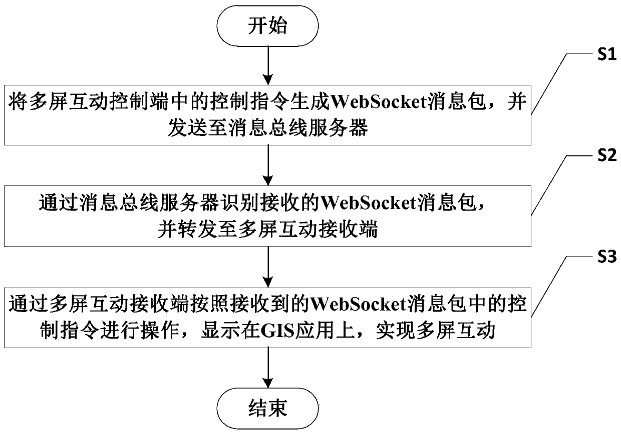
[0036] like figure 1 As shown, the multi-screen interactive method of GIS application based on WebSocket technology includes the following steps:

[0037] S1. Generate a WebSocket message packet from the control command in the multi-screen interactive control terminal, and send it to the message bus server;

[0038] S2. Identify the received WebSocket message packet through the message bus server, and forward it to the mul...


PUM


Abstract

The invention discloses a GIS application multi-screen interaction method based on a WebSocket technology. A WebSocket technology is adopted, operations of GIS applications are encoded, and multi-screen interaction between multiple devices and between two different GIS applications developed based on the same map engine is achieved through transmission of a message bus server; particularly, when the GIS application with very high hardware performance requirement of a receiving end is carried out, the control end can use the GIS application with very low hardware requirements to realize multi-screen interaction with the GIS application of the receiving end, so that the GIS application for commanding the operation of receiving end equipment such as a large screen and a high-performance PC can be controlled through mobile phones and panel light mobile equipment, and the GIS multi-screen interaction is not limited by hardware performance.

Description

technical field [0001] The invention belongs to the technical field of GIS application, and in particular relates to a multi-screen interaction method for GIS application based on WebSocket technology. Background technique [0002] GIS (Geographic Information System or Geo-Information system, geographic information system) is a specific and very important spatial information system. A technical system for collecting, storing, managing, computing, analyzing, displaying and describing geographically distributed data. [0003] Existing GIS applications, especially GIS applications in 3D scenes, have high requirements on the hardware environment and require high-performance graphics cards. However, the hardware configuration of mobile devices such as mobile phones and tablet lights is relatively low, and some applications with high hardware requirements cannot be run. For GIS applications, in some usage scenarios that require multi-screen interaction, it is impossible to realiz...

Claims


Application Information

Patent Timeline
Patent Type & Authority Applications(China)
IPC IPC(8): G06F16/29H04L29/06
CPCG06F16/29H04L69/162
Inventor 杨斌曹晔彭真周翔曾凡袁建华
Owner 四川易利数字城市科技有限公司
Learn More