Method for predicting building height by using satellite images

A technology of building height and satellite imagery, applied in the interpretation of photos, camera devices, etc., can solve the problems of low calculation efficiency and precision, complex methods, etc., and achieve the goal of small workload, simple principle, high calculation accuracy and calculation efficiency Effect

Pending Publication Date: 2020-09-29
HENAN UNIVERSITY
View PDF7 Cites 4 Cited by
  • Summary
  • Abstract
  • Description
  • Claims
  • Application Information

AI Technical Summary

Problems solved by technology

[0004] The purpose of the present invention is to provide a method for predicting the height of buildings using satellite images, which is used to solve the problems of complex and low computational efficiency and precision in existing methods

Method used


Image

  • Method for predicting building height by using satellite images
  • Method for predicting building height by using satellite images
  • Method for predicting building height by using satellite images

Examples


Embodiment Construction

[0033] The specific embodiments of the present invention will be further described below in conjunction with the accompanying drawings.

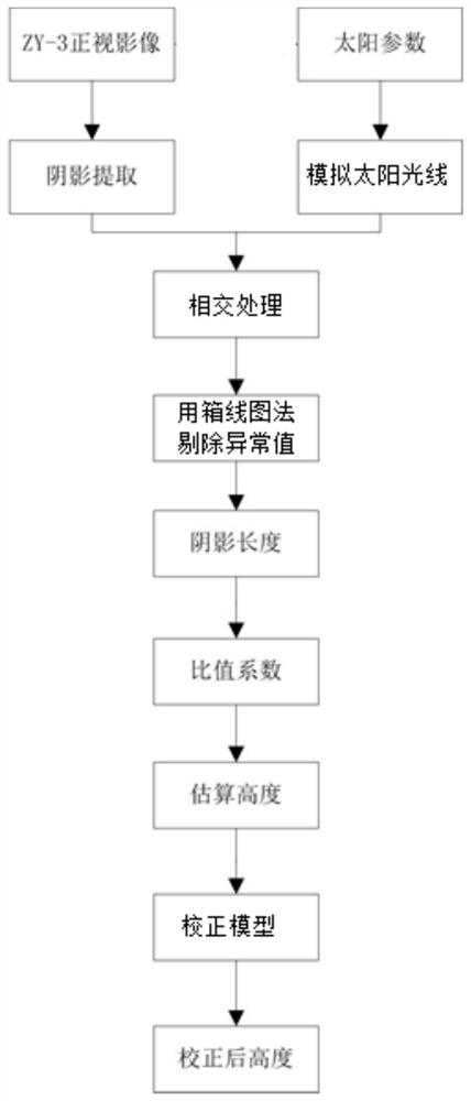
[0034] This embodiment proposes a method for predicting the height of buildings using satellite images. The basic idea is: use the front-facing camera on the ZY-3 satellite to photograph several buildings in the target area to obtain the front-facing images of the buildings, and use the solar The azimuth simulates the sun's rays, intersects the simulated sun's rays with the shadow surface of the building in the front-view image, determines several line segments in the shadow surface, and then uses the boxplot method to eliminate the outliers of the line segments in the shadow surface of the building. Then average the remaining line segments to calculate the shadow length of the building in the orthographic image, that is, the shadow length.

[0035] Then, measure the actual height (i.e. actual measurement height) of setting number buildings ...


PUM


Abstract

The invention relates to a method for predicting the height of a building by utilizing satellite images, and belongs to the technical field of building height measurement. The method comprises the following steps: measuring the height of a small number of buildings in a target area, performing ratio operation on the measured height and the corresponding shadow length in a satellite image, and taking the average value of all ratios as a ratio coefficient for solving the estimated height of each building in combination with the shadow length of each building in the satellite image; and then correcting the estimated height of each building by utilizing a determined correction model to obtain a high-precision corrected height. According to the invention, the method is simple in principle, easyto implement, small in workload, high in calculation precision and calculation efficiency and high in application value, and the solar azimuth angle, the solar altitude angle and the like do not needto be calculated.

Description

technical field [0001] The invention belongs to the technical field of measuring and calculating building heights, and in particular relates to a method for predicting building heights by using satellite images. Background technique [0002] Buildings are the main components of a city, and their height growth reflects the expansion of the city's vertical space. Quickly and accurately extracting the height information of residential buildings is of great significance for studying the volume ratio of buildings and improving the living quality of urban residents. [0003] In the prior art, the Chinese invention patent with the publication number CN108765488A proposes a method for estimating the building height of high-resolution remote sensing images based on shadows. The method detects shadows in the original image to be detected, determines the shadow length, and then Find the sun azimuth, and then calculate the sun altitude angle, and use the obtained shadow length and sun ...

Claims


Application Information

Patent Timeline
Patent Type & Authority Applications(China)
IPC IPC(8): G01C11/02G01C11/14G01C11/34
CPCG01C11/02G01C11/14G01C11/34G01C11/04
Inventor 卢鹤立刘桂芳夏浩铭冯亚飞
Owner HENAN UNIVERSITY
Why Eureka
Try Eureka