Landslide disaster risk regionalization map generation method

A zoning and risk technology, applied in image data processing, geographic information database, structured data retrieval, etc., can solve problems such as small amount of data, long cycle, failure to consider slope dynamic factors, etc., and achieve the effect of avoiding threats and losses

Active Publication Date: 2020-10-30
EAST CHINA UNIV OF TECH
View PDF7 Cites 16 Cited by
  • Summary
  • Abstract
  • Description
  • Claims
  • Application Information

AI Technical Summary

Problems solved by technology

The disadvantages of this method are: the weight coefficients determined by experts are highly subjective, and there are certain differences in the weight coefficients determined by different experts; at the same time, this method also has high cost, low efficiency, long cycle, small amount of data, and point-to-surface, etc. defect
The disadvantage of this method is: the evaluation system is not comprehensive, resulting in inaccurate prediction results
The advantage of this method is that it has high precision and reliability, but the disadvantage is that machine learning (including deep learning, etc.) algorithms require strong computing power; at the same time, when the existing methods determine the non-disaster stable area of ​​the training set, only consider The distance factor between it and the landslide disaster point is not considered, and the influence of dynamic factors such as slope is not considered, so the determination method of the training set is unreasonable

Method used


Image

  • Landslide disaster risk regionalization map generation method
  • Landslide disaster risk regionalization map generation method
  • Landslide disaster risk regionalization map generation method

Examples


Embodiment Construction

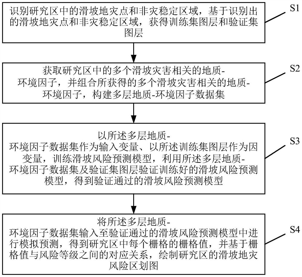
[0052] The preferred embodiments of the present invention will be described below in detail with reference to the accompanying drawings, wherein the accompanying drawings constitute a part of the application and are used together with the embodiments of the present invention to explain the principle of the present invention, and are not used to limit the scope of the present invention.

[0053] A specific embodiment of the present invention discloses a method for generating a landslide disaster risk zoning map. The flowchart is as follows figure 1 As shown, the method includes the following steps:

[0054] Step S1: Identify landslide disaster points and non-disaster stable areas in the study area, and obtain training set layers and validation set layers based on the identified landslide disaster points and non-disaster stable areas.

[0055] It should be noted that the method for generating a landslide disaster risk zoning map described in this embodiment is used to generate the lands...


PUM


Abstract

The invention relates to a landslide disaster risk regionalization map generation method, belongs to the technical field of landslide risk prediction and early warning, and solves the problem of low accuracy of an existing landslide risk prediction method. The method comprises the following steps: identifying landslide disaster points and non-disaster stable areas in a research area, and obtaininga training set layer and a verification set layer; obtaining and combining geological-environmental factors related to a plurality of landslide disasters in the research area, and constructing a multilayer geological-environmental factor data set; training a landslide risk prediction model by taking the constructed data set as an input variable and the training set layer as a dependent variable,and verifying the trained landslide risk prediction model by utilizing the constructed data set and the verification set layer to obtain a successfully verified landslide risk prediction model; and inputting the constructed data set into the verified landslide risk prediction model, carrying out processing to obtain a grid value of each grid in the research area, and drawing a landslide disaster risk regionalization map of the research area based on a corresponding relationship between the grid values and risk levels.

Description

Technical field [0001] The invention relates to the technical field of landslide risk prediction and early warning, in particular to a method for generating a landslide disaster risk zone map. Background technique [0002] Landslides are currently one of the most common natural disasters, especially landslides induced by earthquakes and heavy rainfall, which have brought great harm to traffic and human production and life, and have become an important limiting factor affecting regional development. Therefore, the risk prediction of landslides and the drawing of landslide disaster risk zone maps have important guiding significance for land use planning, urban and rural construction and road development, especially for disaster prevention and early warning of relevant local departments. [0003] The existing methods for generating landslide disaster risk zoning maps mainly include the following three: [0004] First, based on the theoretical analysis of the relationship between disast...

Claims


Application Information

Patent Timeline
Patent Type & Authority Applications(China)
IPC IPC(8): G06F16/29G06T17/05G06Q10/04G06Q50/26
CPCG06Q10/04G06Q50/26G06T17/05G06F16/29
Inventor 吴伟成周晓亭秦耀祖林子瑜鸥鹏辉张阳皇甫文超彭珊鸰邵崇建
Owner EAST CHINA UNIV OF TECH
Why Eureka
Try Eureka