Road gradient estimation method based on portable GPS

A road gradient, portable technology, applied in the direction of measuring inclination, measuring devices, instruments, etc., can solve the problems of the influence of sensor accuracy, the inability of the gradient to meet the needs of high-precision and portable measurement, and the inability to obtain road gradient value sensors. The effect of calculation accuracy, low cost, and simple operation method

Active Publication Date: 2020-11-27
JINAN UNIVERSITY
View PDF6 Cites 7 Cited by
  • Summary
  • Abstract
  • Description
  • Claims
  • Application Information

AI Technical Summary

Problems solved by technology

This method is more to reflect the fluctuation state of the vehicle, it cannot obtain the real road slope value and is easily affected by the sensor installation and sensor accuracy
The slope obtained by this method is difficult to meet the high-precision and portable measurement requirements for the measurement and estimation of motor vehicle exhaust emissions

Method used


Image

  • Road gradient estimation method based on portable GPS
  • Road gradient estimation method based on portable GPS
  • Road gradient estimation method based on portable GPS

Examples


Embodiment

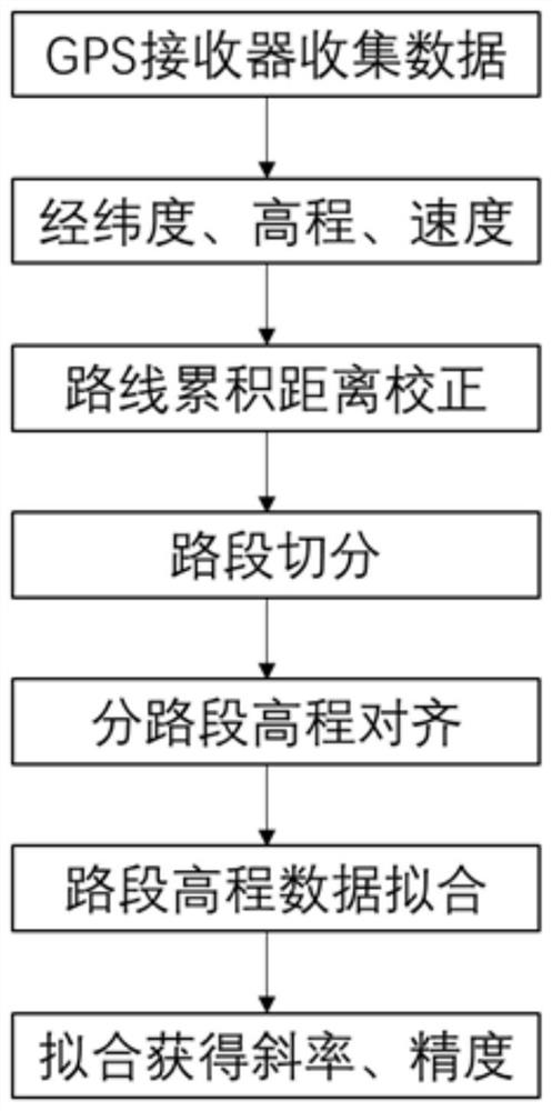
[0045] Taking the actual road emission test of a motor vehicle as an example, the slope data of the tested route needs to be known and requires high precision, such as figure 1 Shown, a kind of road gradient estimation method based on portable GPS of the present invention comprises the following steps:

[0046] S1. Using multiple GPS receivers to collect data, specifically:

[0047] Place one or more portable GPS receivers on the vehicle, and the vehicle will drive through the test road repeatedly several times to collect all the recorded data of the GPS receiver. The data collected by each GPS receiver includes the longitude, latitude and elevation data of the road.

[0048] In this embodiment, 4 portable GPSs are placed on the front end of the test vehicle and fixed, and the test vehicle is driven normally along the vehicle emission test road, and the road section is repeatedly driven 4 times, and a total of 16 route trajectory data are collected.

[0049] S2. Calculate the...


PUM


Abstract

The invention discloses a road gradient estimation method based on a portable GPS. The method comprises the following steps of placing a plurality of GPS receivers on a vehicle to collect data; preprocessing the collected data; dividing a test road, namely determining the segmentation length of a road section by considering the number of data points, and dividing the test road into a plurality ofbranch road sections according to the determined length; aligning the elevation data of the branch road sections, namely aligning the obtained elevation data; and calculating the road gradient of theroad section and quantifying the precision, namely calculating the gradient of each branch road section, estimating the road gradient by performing linear regression on the aligned elevation data of the branch road sections, and deducing the precision of the measured road gradient according to the standard error of the slope estimation of the linear regression. The method provided by the inventioncan be conveniently and accurately obtained through GPS data analysis, is not influenced by the type of the test road and the driving state of vehicles, and can obtain a more accurate slope result through correcting the accumulated distance and the elevation.

Description

technical field [0001] The invention belongs to the technical field of traffic environmental protection, and in particular relates to a method for estimating road slope based on a portable GPS. Background technique [0002] The information provided by the high-precision map is conducive to the system control of the car while driving, which is conducive to reducing the occurrence of traffic accidents, and the mature development of automatic driving technology is also inseparable from the support of high-precision map data, and the road slope is a high-precision map. Therefore, it is of great significance to measure the slope of the road accurately and efficiently. [0003] At present, in terms of road slope measurement at home and abroad, if you want to obtain high-precision road slope data, you need very expensive professional surveying and mapping instruments, and it involves data fusion and calculation, which is relatively complicated. It is very difficult for non-profess...

Claims


Application Information

Patent Timeline
Patent Type & Authority Applications(China)
IPC IPC(8): G01C9/00
CPCG01C9/00
Inventor 余飞郑君瑜钟庄敏黄志炯
Owner JINAN UNIVERSITY
Why Eureka
Try Eureka