Phyllostachys pubescens forest remote sensing recognition method based on satellite images containing red edge bands and phenological differences

A satellite image and remote sensing recognition technology, applied in the field of remote sensing, can solve the problems of difficult bamboo forests, low precision, monitoring moso bamboo forests, etc.

Active Publication Date: 2020-12-18
CHUZHOU UNIV
View PDF5 Cites 7 Cited by
  • Summary
  • Abstract
  • Description
  • Claims
  • Application Information

AI Technical Summary

Problems solved by technology

[0005] The object of the present invention is to provide a kind of remote sensing recognition method of moso bamboo forest based on the satellite images containing red edge band and phenological difference, to solve the difficulty when traditional remote sensing images are used to identify moso bamboo forest, the accuracy is not high, and it is impossible to identify large areas, Technical Problems in Monitoring Moso Bamboo Forest

Method used


Image

  • Phyllostachys pubescens forest remote sensing recognition method based on satellite images containing red edge bands and phenological differences
  • Phyllostachys pubescens forest remote sensing recognition method based on satellite images containing red edge bands and phenological differences
  • Phyllostachys pubescens forest remote sensing recognition method based on satellite images containing red edge bands and phenological differences

Examples


Embodiment Construction

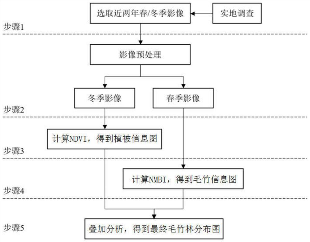
[0029] The specific embodiments of the present invention will be further described in detail by describing the embodiments below with reference to the accompanying drawings, so as to help those skilled in the art have a more complete, accurate and in-depth understanding of the inventive concepts and technical solutions of the present invention.

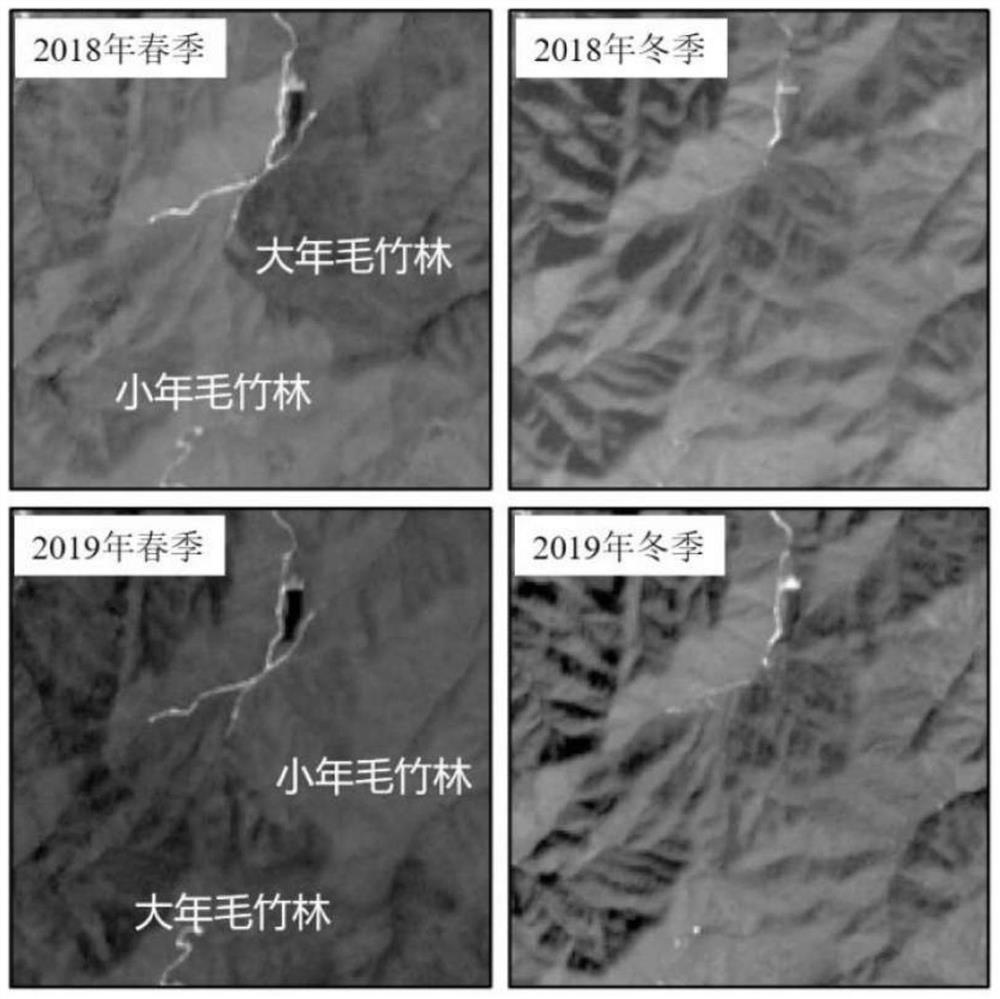
[0030] Since the red edge is closely related to various physical and chemical parameters of vegetation, it is an important indicator band to describe the state and health of plant pigments. For example, the satellite image of Sentinel-2 satellite, which can collect the spectrum of the red edge band, is selected as the original image data for identification.

[0031] The principle of the present invention is: Sentinel-2 data has a spatial resolution of 10m, a revisit period of 5 days, covers 13 spectral bands, and is the only data containing three bands in the red edge range, which is very useful for monitoring vegetation health informa...


PUM


Abstract

The invention discloses a phyllostachys pubescens forest remote sensing recognition method based on satellite images containing red edge bands and phenological differences. The phyllostachys pubescensforest remote sensing recognition method comprises the following steps: step 1, selecting satellite images containing red edge bands in spring and winter i5n recent two years after field investigation; 2, preprocessing the selected satellite image to obtain a processed satellite image; step 3, based on the preprocessed two-stage winter satellite images, calculating normalized difference vegetation indexes NDVI of the two-stage winter satellite images respectively, and applying a threshold segmentation method to extract and obtain a vegetation information graph; 4, based on the preprocessed two-stage spring satellite images, calculating a normalized moso bamboo index NMBI representing the difference between the two-stage spring satellite images, and then applying a threshold segmentation method to extract and obtain a moso bamboo information graph; and step 5, performing superposition analysis on the vegetation information graph and the moso bamboo information graph to obtain a final moso bamboo forest distribution graph. The extraction method is simple, the extracted information is accurate, and the spatial distribution information of the phyllostachys pubescens forest can be mastered by effectively utilizing the remote sensing image.

Description

technical field [0001] The invention belongs to the technical field of remote sensing, and relates to a remote sensing identification method of moso bamboo forests based on satellite images containing red-edge bands and phenological differences. Background technique [0002] my country is the country with the widest distribution of moso bamboo in the world. According to the statistics of the eighth national forest resource inventory (2009-2013), the area of ​​bamboo forest in China is 6.01×10 6 hm 2 , which is the most widely distributed moso bamboo forest, accounting for about 70% of China's bamboo forest area. Moso bamboo grows fast, has high yield, good material and wide application. It is the bamboo species with the greatest economic value in my country. Rapid and accurate extraction of moso bamboo distribution information is of great significance for grasping the distribution scale of moso bamboo, predicting the production of moso bamboo and the economic development o...

Claims


Application Information

Patent Timeline
Patent Type & Authority Applications(China)
IPC IPC(8): G06T7/00G06T7/136G06K9/00
CPCG06T7/0002G06T7/136G06T2207/10032G06T2207/30188G06V20/188G06V20/13
Inventor 李龙伟李楠王妮吴震
Owner CHUZHOU UNIV
Why Eureka
Try Eureka