Highway engineering control measurement method
A technology of engineering control and measurement method, applied in measurement devices, measurement instruments, height/level measurement, etc., can solve problems such as unfavorable international business development and long construction period
- Summary
- Abstract
- Description
- Claims
- Application Information
AI Technical Summary
Problems solved by technology
Method used
Image
Examples
Embodiment Construction
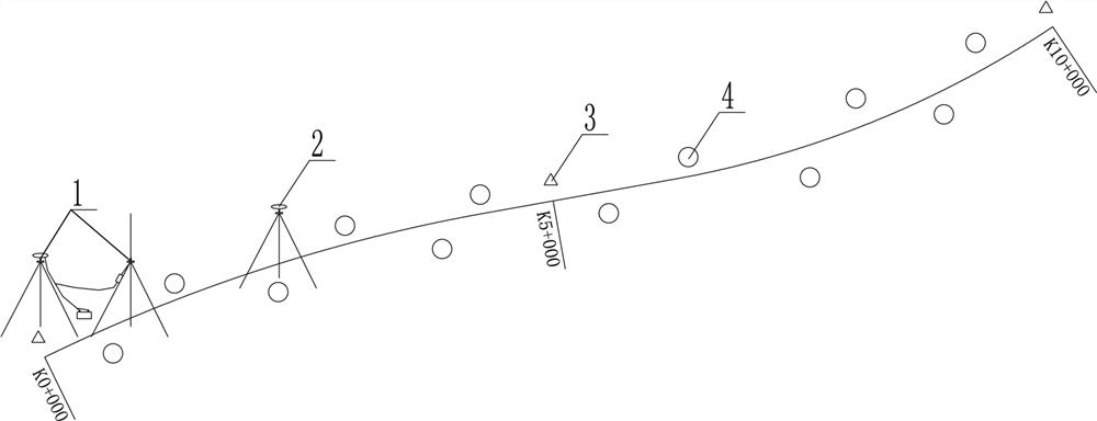
[0017] like figure 1 Among them, a highway engineering control measurement method, it comprises the following steps:
[0018] Step 1, set up the RTK base station 1 with the design survey control point 3 as the starting site, and use the GPS mobile station 2 to collect the coordinates of the encrypted survey control point 4 to the design survey control point 3;
[0019] Step 2, taking design measurement control point 3 as the starting benchmarking point, surveying and drawing a complete leveling closed traverse; performing height difference adjustment calculation;
[0020] Preferably, the combined height measurement of the 4 encrypted control points in this section is completed, and the adjustment calculation is performed to ensure that the elevations of all encrypted control points in this section are closed. Stakeout using any point in the section can meet the accuracy requirements of the construction for the elevation .
[0021] Preferably, in a section of road control net...
PUM
 Abstract
Description
Claims
Application Information
 - R&D
- Intellectual Property
- Life Sciences
- Materials
- Tech Scout
- Unparalleled Data Quality
- Higher Quality Content
- 60% Fewer Hallucinations
Browse by: Latest US Patents, China's latest patents, Technical Efficacy Thesaurus, Application Domain, Technology Topic, Popular Technical Reports.
© 2025 PatSnap. All rights reserved.Legal|Privacy policy|Modern Slavery Act Transparency Statement|Sitemap|About US| Contact US: help@patsnap.com

