Centrality and aggregation measurement method based on city expansion global structure

A technology of urban sprawl and centrality, applied in the field of spatial analysis, to solve problems such as inability to capture dynamic process information, inaccurate evaluation, and spatial characteristics that hinder urban sprawl process.

Active Publication Date: 2021-04-02
WUHAN UNIV
View PDF5 Cites 3 Cited by
  • Summary
  • Abstract
  • Description
  • Claims
  • Application Information

AI Technical Summary

Problems solved by technology

However, landscape indices have an inherent flaw: these indices can only characterize static patterns at a single point in time, but cannot capture dynamic process information [14]
Since urban sprawl is a multidimensional process, a vague and

Method used


Image

  • Centrality and aggregation measurement method based on city expansion global structure
  • Centrality and aggregation measurement method based on city expansion global structure
  • Centrality and aggregation measurement method based on city expansion global structure

Examples


Embodiment

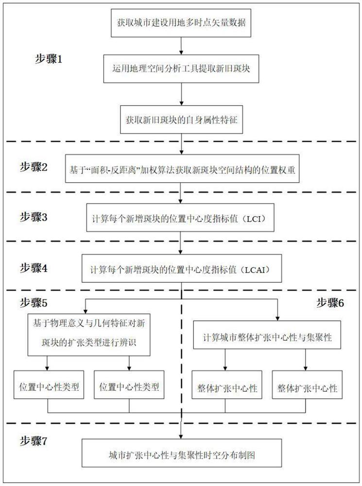
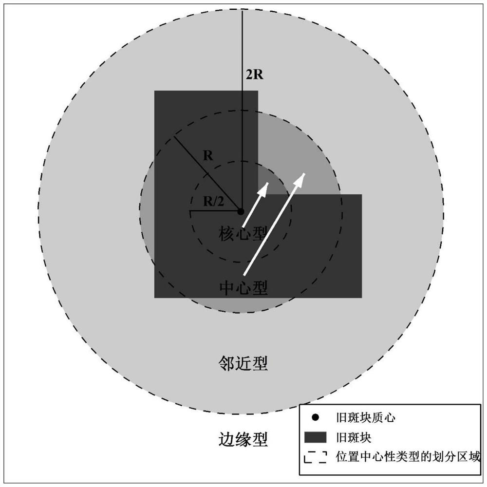
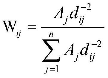
[0063] The present invention provides a method for measuring centrality and agglomeration based on the global structure of urban expansion. For the process, see figure 1 , including the following steps:

[0064] Step 1: Obtain the multi-time-point vector data of urban construction land, and then obtain the spatial scope and characteristics of the newly added urban construction land (new patch) and the original construction land (old patch) by comparing the spatial differences of construction land at connected time points;

[0065] Step 1.1: Vectorize the acquired geospatial data, extract the urban construction land at consecutive time points, and use the geospatial analysis tool (Erase) in ArcGIS to erase the urban construction land vector data at the next point in time and erase the data at the previous point in time to obtain new spots block, the old patch is the vector data of the previous time point;

[0066] Step 1.2: Use the spatial data calculation tool to obtain the o...


PUM


Abstract

The invention discloses a centrality and aggregation measurement method based on a city expansion global structure. The method comprises the steps: providing a position centrality index (LCI), whereinthe index adopts an 'area inverse distance' weighting algorithm to obtain the position weight of a newly added urban patch relative to an original urban overall space structure, and capturing the dynamic characteristics of an urban expansion structure by utilizing the geometrical characteristics of a circle. The method further provides another index, namely a central aggregation index (LCAI), andthe index describes the evolution heterogeneity of the urban form by combining the attributes of the new plaques on the basis of considering the urban expansion global space structure. According to the method, the indexes are combined, the dynamic evaluation blank of the urban expansion centrality is filled up by clearly revealing the global structure characteristics, the performance of identifying the urban expansion aggregation heterogeneity is improved, the expansion characteristic type of the urban newly-added land space is clarified, and the urban expansion aggregation heterogeneity is improved. The practical application requirements of reflecting different city expansion characteristics from bottom to top are met.

Description

technical field [0001] The invention belongs to the technical field of spatial analysis, in particular to a method for measuring centrality and agglomeration based on the overall structure of urban expansion. Background technique [0002] Urbanization is accompanied by the spatial expansion of urban land, with serious impacts on resources, the environment and society [1–2] . There is a consensus that rational use of land resources requires a better understanding of the process of urban sprawl [3–5] . Therefore, quantitative evaluation indicators of urban sprawl processes have been considered as powerful means to understand urban sprawl, which has attracted increasing attention from the urban science community in recent years. [6–7] . [0003] The landscape index is one of the most widely used methods to describe the spatial pattern of urban sprawl [8–10] , most of the landscape indices are developed based on information theory, fractal geometry, and spatial statistics, ...

Claims


Application Information

Patent Timeline
IPC IPC(8): G06Q10/06G06T17/05G06K9/62G06Q50/26
CPCG06Q10/06393G06T17/05G06Q50/26G06F18/24
Inventor 焦利民刘稼丰毛文婧
Owner WUHAN UNIV
Why Eureka
Try Eureka