Surveying and mapping aircraft and management control method thereof

An aircraft and flying height technology, applied in aircraft, unmanned aircraft, aircraft parts, etc., can solve problems such as terrain photographing blocking, unfavorable terrain comprehensive surveying and mapping operations, etc.

Active Publication Date: 2021-04-13
SHENZHEN AIHUA RECONNAISSANCE ENG CO LTD
View PDF7 Cites 1 Cited by
  • Summary
  • Abstract
  • Description
  • Claims
  • Application Information

AI Technical Summary

Problems solved by technology

[0003] The existing surveying and mapping aircraft body is generally composed of a rotating platform, a surveying and mapping camera installed at the lower end of the rotating platform, a support rod and a motor-driven rotating blade. The rotating platform is used to change the angle of the surveying and mapping camera, and the surveying and mapping camera is used for photography and Generate 3D point clouds and models, and send them to the remote control terminal through the signal module. In the process of changing the shooting angle of the surveying and mapping camera by using the rotating pan / tilt, since the support rod of the surveying and mapping aircraft is fixed and the lower end of the support rod is located at the bottom of the surveying and mapping camera. Below, when the surveying and mapping camera performs a large angle conversion, the support rods are likely to appear in the imaging image of the surveying and mapping camera, which hinders the shooting of the landform and does not use the comprehensive surveying and mapping operation of the landform. Therefore, we propose a surveying and mapping aircraft and its management control method to solve this problem

Method used


Image

  • Surveying and mapping aircraft and management control method thereof
  • Surveying and mapping aircraft and management control method thereof
  • Surveying and mapping aircraft and management control method thereof

Examples


Embodiment Construction

[0030] In order to make the technical means, creative features, goals and effects achieved by the present invention easy to understand, the present invention will be further described below in conjunction with specific embodiments.

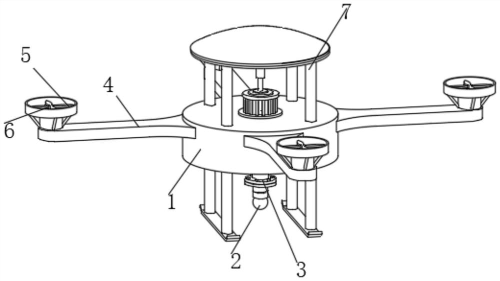
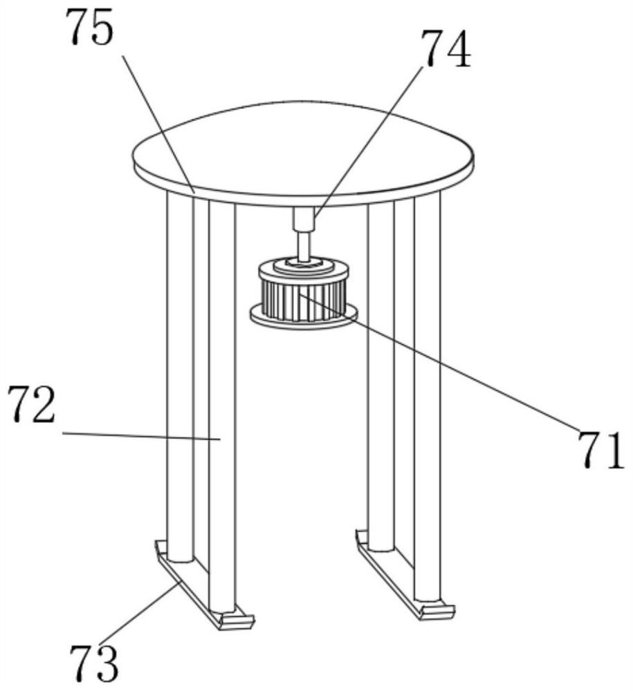
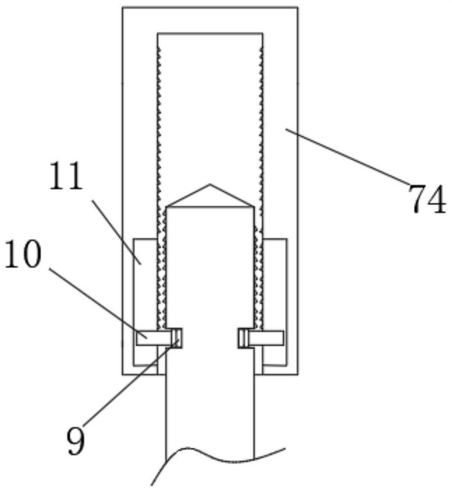
[0031] In the description of the present invention, it should be noted that the terms "upper", "lower", "inner", "outer", "front end", "rear end", "both ends", "one end", "another end" The orientation or positional relationship indicated by etc. is based on the orientation or positional relationship shown in the drawings, and is only for the convenience of describing the present invention and simplifying the description, rather than indicating or implying that the referred device or element must have a specific orientation, use a specific Azimuth configuration and operation, therefore, should not be construed as limiting the invention. In addition, the terms "first" and "second" are used for descriptive purposes only, and should not be understood ...


PUM


Abstract

The invention discloses a surveying and mapping aircraft which comprises an aircraft body, a plurality of sets of wing arms are installed on the outer wall of the aircraft body, rotating fan blades driven by a motor are installed on the multiple sets of wing arms, protection rings are arranged on the peripheries of the multiple sets of rotating fan blades, and the multiple sets of protection rings are fixedly connected with the multiple sets of wing arms; a rotary holder is installed at the bottom of the aircraft body, a surveying and mapping camera is installed at the lower end of the rotary holder, and a height-adjustable supporting piece is installed on the aircraft body and penetrates through the aircraft body. According to the surveying and mapping aircraft, the surveying and mapping aircraft is provided with the adjustable supporting piece, the height of the lower end of the supporting rod can be changed, so that the surveying and mapping sight line of a surveying and mapping camera cannot be blocked, and surveying and mapping are facilitated; the output shaft of the rotating motor is provided with a circular ring with two groups of sliding rods; the output shaft of the rotating motor 7 can be prevented from being screwed out of the threaded sleeve.

Description

technical field [0001] The invention relates to the field of surveying and mapping drone equipment, in particular to a surveying and mapping aircraft and a management and control method thereof. Background technique [0002] Surveying and mapping drones, referred to as surveying and mapping aircraft, are unmanned surveying and mapping drones controlled by radio remote control equipment and self-contained program control devices, or completely or intermittently autonomously operated by on-board computers. [0003] The existing surveying and mapping aircraft body is generally composed of a rotating platform, a surveying and mapping camera installed on the lower end of the rotating platform, a support rod and a motor-driven rotating blade. The rotating platform is used to change the angle of the surveying and mapping camera, and the surveying and mapping camera is used for photography and Generate 3D point clouds and models, and send them to the remote control terminal through ...

Claims


Application Information

Patent Timeline
Patent Type & Authority Applications(China)
IPC IPC(8): B64D47/08B64D45/00B64C39/02
CPCB64D47/08B64D45/00B64C39/02B64U50/19B64U30/20B64U2101/30B64U10/10
Inventor 南智勇莫伟生付仁俊毛永强张体
Owner SHENZHEN AIHUA RECONNAISSANCE ENG CO LTD
Why Eureka
Try Eureka