SASTF prediction method for fault lake basin hydrocarbon source rock in low-exploration new area
A prediction method and technology for source rocks, which are applied in measurement devices, geophysical measurements, seismology for logging records, etc., can solve the problem of inability to effectively predict source rocks, and achieve important application prospects and economic value. , the effect of reducing the risk of oil and gas exploration and improving the success rate of oil and gas exploration
- Summary
- Abstract
- Description
- Claims
- Application Information
AI Technical Summary
Problems solved by technology
Method used
Image
Examples
Embodiment 1
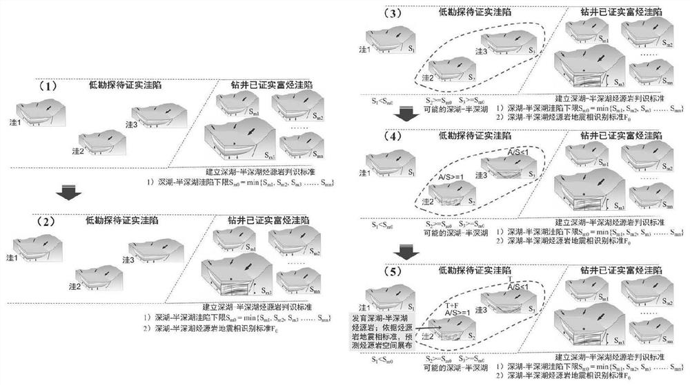
[0031] Embodiment 1, with reference to figure 1 , new low-exploration area A, a SASTF prediction method for source rocks in faulted lacustrine basins in low-exploration new areas, including the following steps:
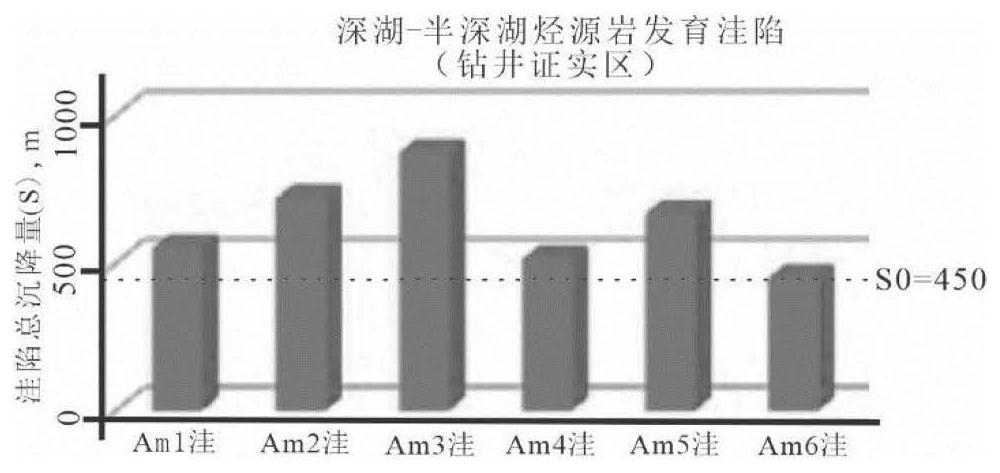
[0032] 1) In 6 hydrocarbon-rich sags that have been confirmed by drilling, the total subsidence S m (Total Subsidence): S m1 ,S m2 ,S m3 ,...,S m6 , and find the minimum value S m0 =min{S m1 ,S m2 ,S m3 ... S m6} = 450 as the lower limit of the environmental standard subsidence of a developable deep-semi-deep lake;
[0033] S m = S T +S Th (1)
[0034]
[0035]
[0036] Among them, S m : total settlement, m; S T : Structural settlement, m; S Th : heat settlement, m; ρ m : mantle density, 3.33g / cm 3 ; ρ s : average density of sediment, 2.30g / cm 3 ; ρ w : Lake water density, 1.00g / cm 3 ;H c : thickness of sediment filling corrected by compaction, m; W d : ancient water depth, m; ΔS L : Relative to the current paleo-lake level change, m; β...
Embodiment 2
[0044] Embodiment 2, with reference to figure 1 , new low-exploration area B, a SASTF prediction method for source rocks in faulted lake basins in low-exploration new areas, including the following steps:
[0045] 1) In 5 hydrocarbon-rich sags that have been confirmed by drilling, the total subsidence S m (Total Subsidence): S m1 ,S m2 ,S m3 ,...,S m5 , and find the minimum value S m0 =min{S m1 ,S m2 ,S m3 ... S m5}=480 is used as the lower limit of the environmental standard subsidence of the developable deep-semi-deep lake;
[0046] S m = S T +S Th (1)
[0047]
[0048]
[0049] Among them, S m : total settlement, m; S T : Structural settlement, m; S Th : heat settlement, m; ρ m : mantle density, 3.33g / cm 3 ; ρ s : average density of sediment, 2.30g / cm 3 ; ρ w : Lake water density, 1.00g / cm 3 ;H c : thickness of sediment filling corrected by compaction, m; W d : ancient water depth, m; ΔS L : Relative to the current paleo-lake level change, m;...
PUM
 Abstract
Description
Claims
Application Information
 - R&D
- Intellectual Property
- Life Sciences
- Materials
- Tech Scout
- Unparalleled Data Quality
- Higher Quality Content
- 60% Fewer Hallucinations
Browse by: Latest US Patents, China's latest patents, Technical Efficacy Thesaurus, Application Domain, Technology Topic, Popular Technical Reports.
© 2025 PatSnap. All rights reserved.Legal|Privacy policy|Modern Slavery Act Transparency Statement|Sitemap|About US| Contact US: help@patsnap.com


