Aerial seeding bioremediation method for coal mining subsidence area

A coal mining subsidence area and bioremediation technology, applied in fertilization methods, seeding, aircraft, etc., can solve the problems of wasting seeds, restricting the application and promotion of drone aerial sowing technology, and large fluctuations, so as to ensure safety, accurate sowing, The effect of saving labor cost

Active Publication Date: 2021-06-15
CHINA UNIV OF MINING & TECH (BEIJING) +1
View PDF8 Cites 0 Cited by
  • Summary
  • Abstract
  • Description
  • Claims
  • Application Information

AI Technical Summary

Problems solved by technology

However, in coal mining subsidence areas, the ground is broken and undulating. This environment limits the application and promotion of drone aerial seeding technology in vegetation restoration in coal mining areas, and seeding operations that do not consider slope and ground coverage will also waste seeds.

Method used


Image

  • Aerial seeding bioremediation method for coal mining subsidence area
  • Aerial seeding bioremediation method for coal mining subsidence area
  • Aerial seeding bioremediation method for coal mining subsidence area

Examples


Embodiment 1

[0051] Embodiment 1. Design of aerial seeding test in the coal mining subsidence area of ​​Ningtiaota Coal Mine

[0052] 1. Overview of the test area

[0053] The test site is located in Ningtiaota Coal Mining Area, Shenmu City, Yulin City, Shaanxi Province, which belongs to the Loess Plateau area, where underground coal mining causes surface subsidence.

[0054] 2. Materials and equipment

[0055] (1) Design the tested seeds: alfalfa.

[0056] (2) The UAV used in the test is Tiantu M8A PRO, with a maximum payload of 20kg.

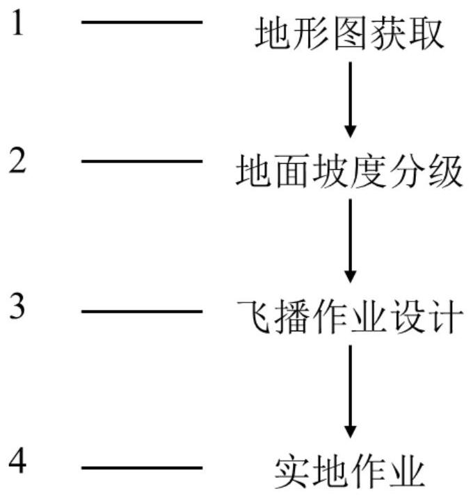
[0057] 3. Process flow

[0058] (1) Obtain topographic map

[0059] The topographic map is measured by digital mapping method, the design area is 2100 mu (1400007 square meters), and the ground slope is between 1.94° and 59.04°.

[0060] (2) Ground slope classification

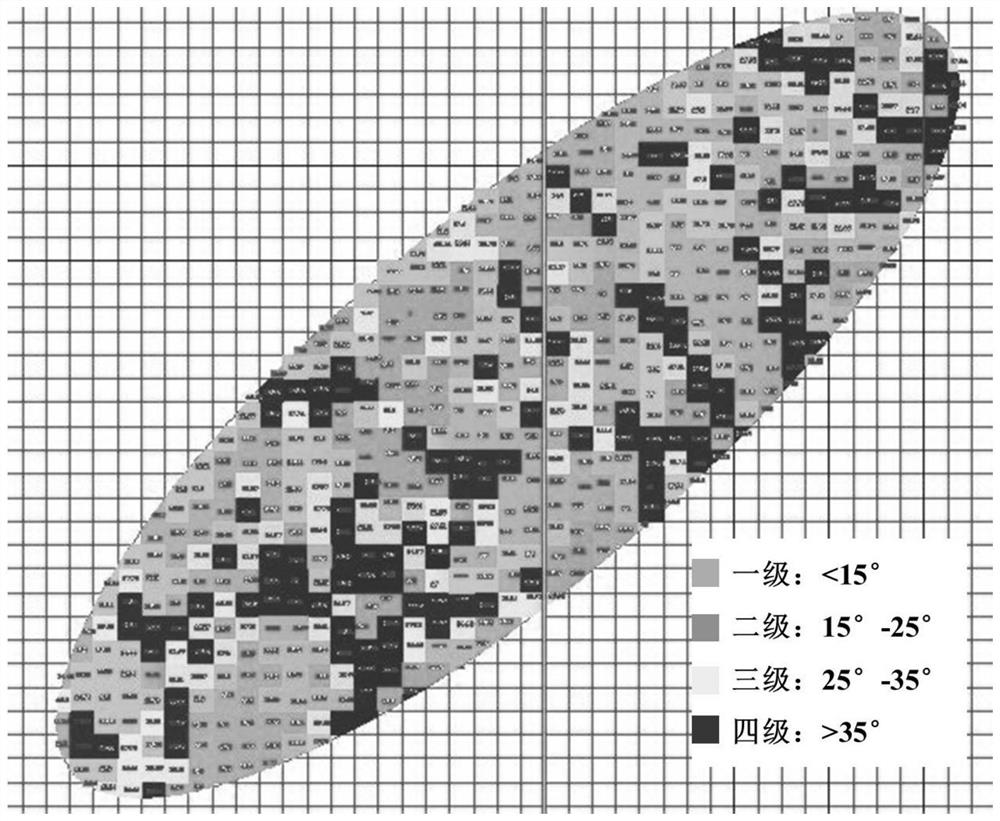
[0061] Using AutoCAD drawing software to analyze the gridded topographic map of the mining area with an accuracy of 50m, the slope classification results ( image 3), the first grad...

Embodiment 2

[0069] Embodiment 2, Zhangjiamao Coal Mine Coal Mining Subsidence Area Aerial Seeding Test Design

[0070] 1. Overview of the test area

[0071] The test site is located in Miaoqu Village, Ningtiaota Coal Mining District, Shenmu City, Yulin City, Shaanxi Province, which belongs to the Loess Plateau area, where underground coal mining causes surface subsidence.

[0072] 2. Materials and equipment

[0073] (1) Design the tested seeds: alfalfa.

[0074] (2) The UAV used in the test is Tiantu M8A PRO, with a maximum payload of 20kg.

[0075] 3. Process flow

[0076] (1) Obtain topographic map

[0077] The topographic map is measured by digital mapping method, the design area is 1000 mu (666667 square meters), and the slope range is between 0° and 54.21°.

[0078] (2) Ground slope classification

[0079] Using AutoCAD drawing software to analyze the gridded topographic map of the mining area with an accuracy of 50m, the slope classification results ( Figure 4 ), the first g...

Embodiment 3

[0084] Example 3. Aerial sowing test of alfalfa seeds in the coal mining subsidence area of ​​Zhangjiamao Coal Mine

[0085] 1. Overview of the test area

[0086] The test site is located in Muguashu Village, Zhangjiamao Coal Mining District, Shenmu City, Yulin City, Shaanxi Province. It belongs to the Loess Plateau area. Underground coal mining causes surface subsidence and cracks.

[0087] 2. Materials and equipment

[0088] (1) Seeds tested: alfalfa.

[0089] (2) The UAV used in the test is Tiantu M8A PRO, with a maximum payload of 20kg.

[0090] 3. Process flow

[0091] (1) Obtain topographic map

[0092] The topographic map is measured by digital surveying method, and the design area is 15 mu (10000.05 square meters).

[0093] (2) Ground slope classification

[0094] The slope of the aerial seeding test area is between 25° and 35°, which is the third level in the ground slope classification.

[0095] (3) Aerial seeding operation design

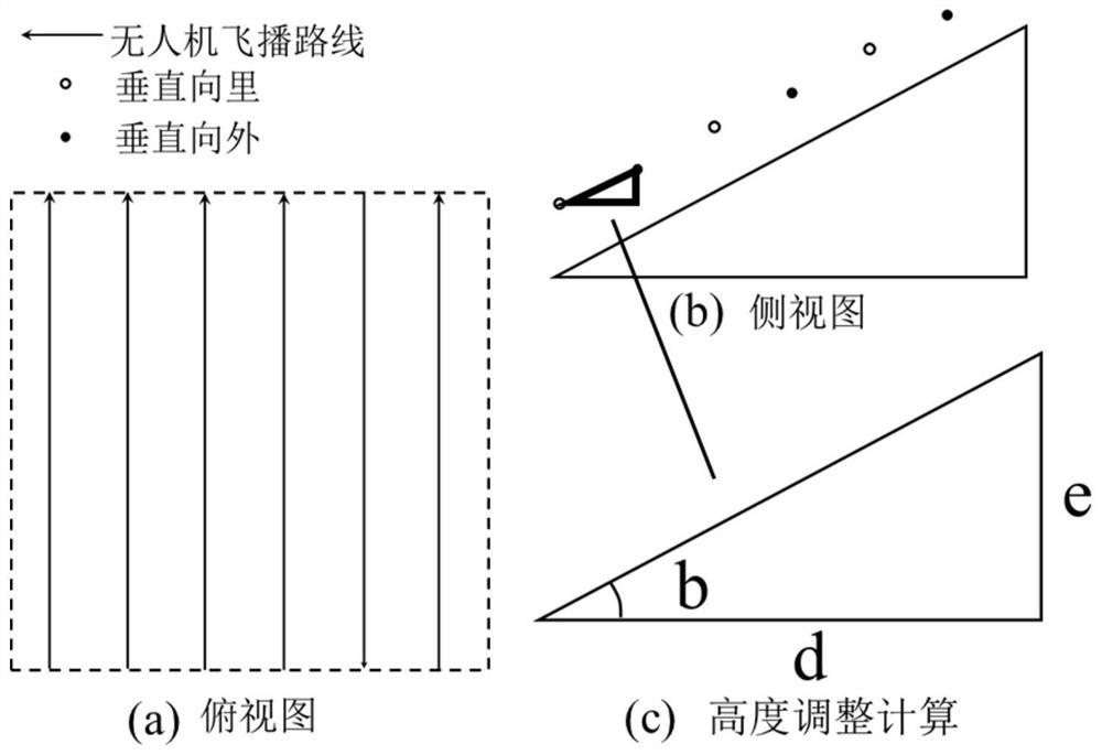
[0096] The ground coverage...


PUM


Abstract

The invention discloses an aerial seeding bioremediation method for a coal mining subsidence area. The aerial seeding bioremediation method for the coal mining subsidence area comprises the following steps: acquiring a topographic map of the coal mining subsidence area; performing gradient grading on the topographic map; determining an aerial seeding operation seeding coefficient according to a gradient grading result and the ground coverage rate of the coal mining subsidence area; determining height adjustment parameters in the aerial seeding process of a unmanned aerial vehicle; and performing aerial seeding operation by adopting the unmanned aerial vehicle according to the ground gradient grading result, the aerial seeding operation seeding coefficient and the height adjustment parameters. The slope grading aerial seeding technical standard determined by the aerial seeding bioremediation method for the coal mining subsidence area can adapt to a complex terrain of the coal mining subsidence area, and the safety of the unmanned aerial vehicle is guaranteed; the sowing amount is set in a grading mode according to the ground coverage rate, so that efficient and accurate sowing can be realized; the determined height adjustment parameters can ensure that the unmanned aerial vehicle always keeps an approximately equal vertical distance from the ground within a unit operation range; the unmanned aerial vehicle performs aerial seeding remote control operation, so that the influence of personnel entering the coal mining subsidence area on the environment is avoided, and the labor cost can be saved.

Description

technical field [0001] The invention relates to an aerial seeding bioremediation method in a coal mining subsidence area, belonging to the field of ecological restoration. Background technique [0002] The western part of my country is located in arid and semi-arid areas, and the ecological environment is fragile. Underground coal mining has caused rock formation and surface movement, disturbed the surface soil, and disturbed the growth of surface plants. The ecological environment in the coal mining area has a certain self-repair ability, but the natural restoration speed is relatively slow. How to quickly and efficiently restore the ecology of the coal mining area is the key to solving the environmental problems in this area. At the same time, there is a large degree of ground surface fragmentation after coal mining in underground mines, and there are even places that are difficult for people to reach, which limits the implementation of traditional artificial short-distanc...

Claims


Application Information

Patent Timeline
Patent Type & Authority Applications(China)
IPC IPC(8): A01C7/00A01C7/08B64D1/18G05D1/10
CPCA01C7/00A01C7/085B64D1/18G05D1/101A01C7/008A01C21/005B64U2101/30A01C7/08A01C21/00B64C39/024
Inventor 毕银丽马少鹏高雅坤张龙杰周会丽
Owner CHINA UNIV OF MINING & TECH (BEIJING)
Why Eureka
Try Eureka