A Height Measurement Method with Plane Positioning and Millimeter-Level Accuracy

A technology of plane positioning and elevation measurement, which is applied in the directions of height/level measurement, measurement device, surveying and navigation, etc. It can solve the problems of difficulty in meeting and the elevation accuracy of satellite leveling technology is difficult to meet, and achieve the effect of improving the elevation accuracy.

Active Publication Date: 2022-02-15
SOUTH CHINA AGRI UNIV
View PDF6 Cites 0 Cited by
  • Summary
  • Abstract
  • Description
  • Claims
  • Application Information

AI Technical Summary

Problems solved by technology

However, laser leveling technology can only measure high-precision elevation information, which is difficult to meet the requirements of modern intelligent leveling technology for three-dimensional terrain, path planning and intelligent control, and satellite leveling technology can hardly meet the requirements of high-precision leveling occasions, so there are It is necessary to propose a scheme with plane positioning and millimeter-level height measurement accuracy

Method used


Image

  • A Height Measurement Method with Plane Positioning and Millimeter-Level Accuracy
  • A Height Measurement Method with Plane Positioning and Millimeter-Level Accuracy
  • A Height Measurement Method with Plane Positioning and Millimeter-Level Accuracy

Examples


Embodiment 1

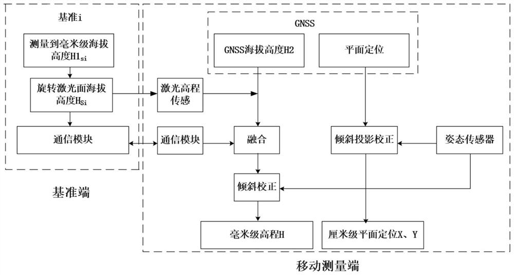
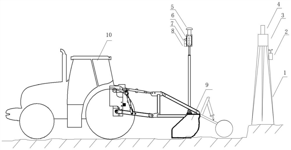
[0036] like image 3 In this embodiment, a motor grader is used to specifically illustrate an elevation measurement method with plane positioning and millimeter-level accuracy. Sensors, communication modules at the reference end, GNSS at the reference end, GNSS at the mobile measurement end, communication modules at the mobile measurement end, motor grader controller, attitude sensor at the mobile measurement end, tripods, grader shovels, and tractors.

[0037] The tripod is erected on the ground, the laser transmitter is installed on the tripod, the position measurement module GNSS of the reference system is installed at a fixed vertical distance relative to the rotating laser surface Si, and the communication module of the reference end is fixed on the tripod.

[0038] Fix the laser elevation sensor on the mast of the machine, where the elevation zero position of the laser elevation sensor is the longitudinal center of the photoelectric sensor array, and the GNSS on the mobi...

Embodiment 2

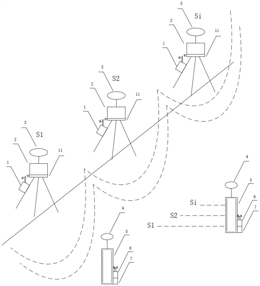
[0057] In this embodiment, see figure 2 To illustrate that the rotating laser datum reference plane consists of multiple datum systems.

[0058] When the datum reference planes are multiple sets of datum systems composed of the same reference plane, the datum systems are named datum 1, datum 2... For a certain distance, the position measurement module adopts GNSS, including laser transmitter, laser elevation sensor, communication module at the reference end, GNSS at the reference end, GNSS at the mobile measurement end, communication module at the mobile measurement end, attitude sensor at the mobile measurement end, and tripod.

[0059] The tripod is erected on the ground, the laser transmitter is installed on the lifting platform, and the lifting platform is installed on the tripod. Each reference system is turned on at the same time. The position measurement module GNSS static measurement of each reference system obtains the measurement module GNSS millimeter-level altit...


PUM


Abstract

A height measurement method with plane positioning and millimeter-level precision, a is composed of a single or multiple sets of reference systems to rotate the laser reference plane; b, the reference system obtains the altitude of the rotating laser reference plane; c, the altitude transmission in step b To the mobile measurement terminal; d mobile measurement terminal receiving; e mobile measurement terminal obtains its own altitude and plane positioning information; f mobile measurement terminal obtains the laser elevation deviation of the laser elevation sensor relative to the rotating laser reference plane; g fuses the altitude of step b , laser elevation deviation, the altitude of step e, to obtain the fusion elevation value; h uses the tilt information of the attitude sensor at the mobile measuring end to perform tilt correction, and obtains the millimeter-level elevation measurement value; i uses the tilt information of the attitude sensor to perform projection correction, and obtains centimeters Level precision plane positioning. The invention has high measurement precision, can meet the requirements of modern intelligent leveling technology, and belongs to the field of intelligent machinery.

Description

technical field [0001] The invention relates to the field of intelligent machinery, in particular to an elevation measurement method with plane positioning and millimeter-level precision. Background technique [0002] At present, my country has developed from traditional profiling and leveling technology to high-precision leveling methods such as laser leveling technology and satellite leveling technology. Among them, laser leveling technology and satellite leveling technology have greatly improved the traditional leveling method and greatly improved the construction leveling accuracy. [0003] Laser leveling technology and satellite leveling technology have been widely used in various fields around the world. GNSS global navigation satellite system is a satellite system covering global autonomous spatial positioning. It integrates navigation systems such as American GPS, Chinese BDS, and Russian GLONASS, with good stability and performance. and precision. [0004] With the...

Claims


Application Information

Patent Timeline
Patent Type & Authority Patents(China)
IPC IPC(8): G01C5/00
CPCG01C5/00
Inventor 胡炼黄浩何杰罗锡文臧英陈高隆王志敏冯达文
Owner SOUTH CHINA AGRI UNIV
Why Eureka
Try Eureka