BDS or GPS-based medium-long baseline multi-frequency RTK positioning rapid convergence method

A fast convergence, medium and long base technology, applied in the field of satellite navigation signal processing, it can solve the problems of low success rate of ambiguity resolution, poor quality of observations, large ionospheric delay error and tropospheric delay error, etc.

Pending Publication Date: 2021-07-16
上海寰果信息科技有限公司
View PDF0 Cites 2 Cited by
  • Summary
  • Abstract
  • Description
  • Claims
  • Application Information

AI Technical Summary

Problems solved by technology

[0003] The conventional RTK operation distance generally does not exceed 20km. With the increase of the baseline length, the atmospheric correlation between the base station and the rover station decreases. Long, the success rate of ambiguity resolution is low, and the reliability cannot be guaranteed. In addition, the poor quality of observations of low-angle satellites is also an important reason affecting the resolution of ambiguity segments. Low-angle satellites not only have ionospheric delay errors and tropospheric delay errors Larger, observation noise and multipath effects are relatively obvious

Method used


Image

  • BDS or GPS-based medium-long baseline multi-frequency RTK positioning rapid convergence method
  • BDS or GPS-based medium-long baseline multi-frequency RTK positioning rapid convergence method
  • BDS or GPS-based medium-long baseline multi-frequency RTK positioning rapid convergence method

Examples


Embodiment Construction

[0020] The specific implementation of the BDS or GPS-based fast convergence method for medium and long baseline multi-frequency RTK positioning of the present invention will be described in detail below.

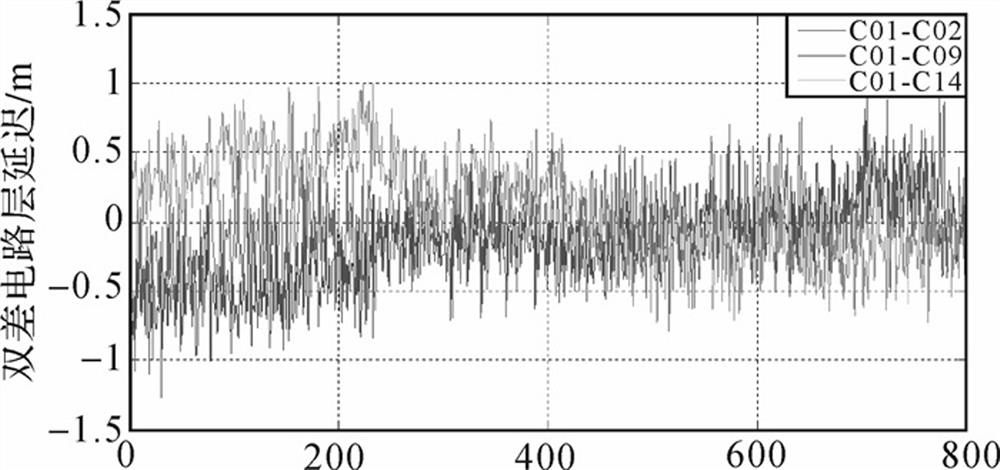
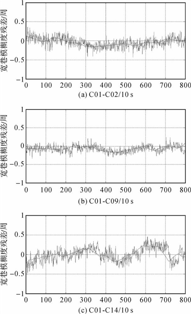
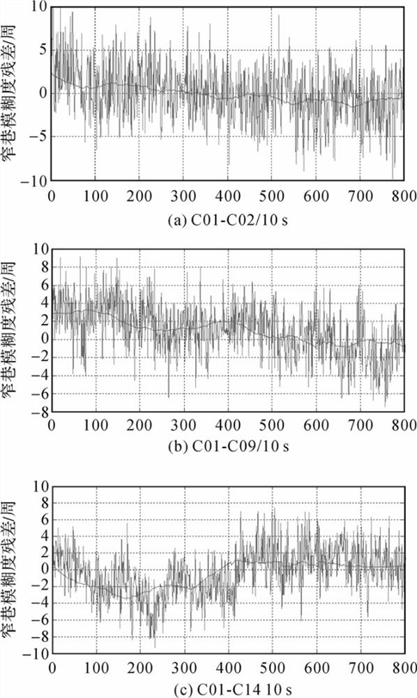
[0021] Through the long baseline multi-frequency RTK positioning algorithm in BDS or GPS, the two ultra-wide lane ambiguities of BDS are quickly fixed with a high success rate, and then the BDS wide lane ambiguity is obtained by transformation, and then used to assist in improving the GPS wide lane ambiguity Finally, the strategy of parameterizing the ionospheric delay error and the tropospheric delay error is adopted to speed up the convergence speed of the narrow-lane ambiguity floating-point solution, shorten the time for the first fixation of the ambiguity, and use the wide-lane ambiguity solution model and The floating-point solution is calculated by the Kalman filter method with added wide-lane ambiguity parameters. The double-difference observation equation in GNSS rel...


PUM


Abstract

The invention relates to the technical field of automatic information processing, and discloses a BDS or GPS-based medium-long baseline multi-frequency RTK positioning rapid convergence method, which comprises the following steps: through a BDS or GPS medium-long baseline multi-frequency RTK positioning algorithm, rapidly fixing two ultra-wide lane ambiguity of a BDS at a relatively high success rate, then obtaining BDS wide lane ambiguity through transformation, then, improving the GPS wide-lane ambiguity fixing success rate in an auxiliary mode, finally, increasing the convergence speed of a narrow-lane ambiguity floating point solution by adopting a strategy of parameterizing ionosphere delay errors and troposphere delay errors, and shortening the time for fixing the ambiguity for the first time; and calculating a floating point solution by using a wide-lane ambiguity solution model and a Kalman filtering method added with wide-lane ambiguity parameters. According to the method, the satellite with the fixed height higher than the set ambiguity to solve the cut-off elevation angle is positioned.

Description

technical field [0001] The invention relates to the technical field of satellite navigation signal processing, in particular to a fast convergence method for medium and long baseline multi-frequency RTK positioning based on BDS or GPS. Background technique [0002] As the global satellite navigation system enters the multi-system era, the number of visible navigation satellites in the sky is increasing continuously, and my country's Beidou satellite navigation system (BDS) has also begun to provide users with three-frequency navigation signals, which is conducive to improving RTK (real-time dynamic ) positioning accuracy and reliability. [0003] The conventional RTK operation distance generally does not exceed 20km. With the increase of the baseline length, the atmospheric correlation between the base station and the rover station decreases, and the residual ionospheric delay and tropospheric delay error of the double differential roar exceed half a wavelength, resulting in ...

Claims


Application Information

Patent Timeline
Patent Type & Authority Applications(China)
IPC IPC(8): G01S19/43G01S19/24
CPCG01S19/24G01S19/43
Inventor 袁纯
Owner 上海寰果信息科技有限公司
Why Eureka
Try Eureka