
Near real-time deformation monitoring method for multi-gnss long baselines with multiple base stations

A near-real-time, long-baseline technology, applied in the direction of electric/magnetic solid deformation measurement, electromagnetic measurement devices, etc., can solve the problems of small number of users, low processing efficiency, and inability to meet a wide range of business needs, and improve the solution Efficiency, avoiding redundant processing, and dividing flexibly

Active Publication Date: 2019-09-24
QIANXUN SPATIAL INTELLIGENCE INC +1
View PDF4 Cites 0 Cited by
  • Summary
  • Abstract
  • Description
  • Claims
  • Application Information

AI Technical Summary

Problems solved by technology

In order to meet the near-real-time deformation monitoring business needs of large-scale spans such as dangerous building monitoring, landslide monitoring along long-distance railway lines, and settlement monitoring of long-distance power towers across the country, the current traditional algorithm for short and medium baseline lengths cannot meet large-scale business needs. Moreover, the traditional processing algorithm is not efficient for the working conditions of tens of thousands of monitoring points.
In addition, traditional deformation monitoring is a business developed for specific needs, and the number of users is small

Method used


Image

  • Near real-time deformation monitoring method for multi-gnss long baselines with multiple base stations
  • Near real-time deformation monitoring method for multi-gnss long baselines with multiple base stations
  • Near real-time deformation monitoring method for multi-gnss long baselines with multiple base stations

Examples


Embodiment Construction

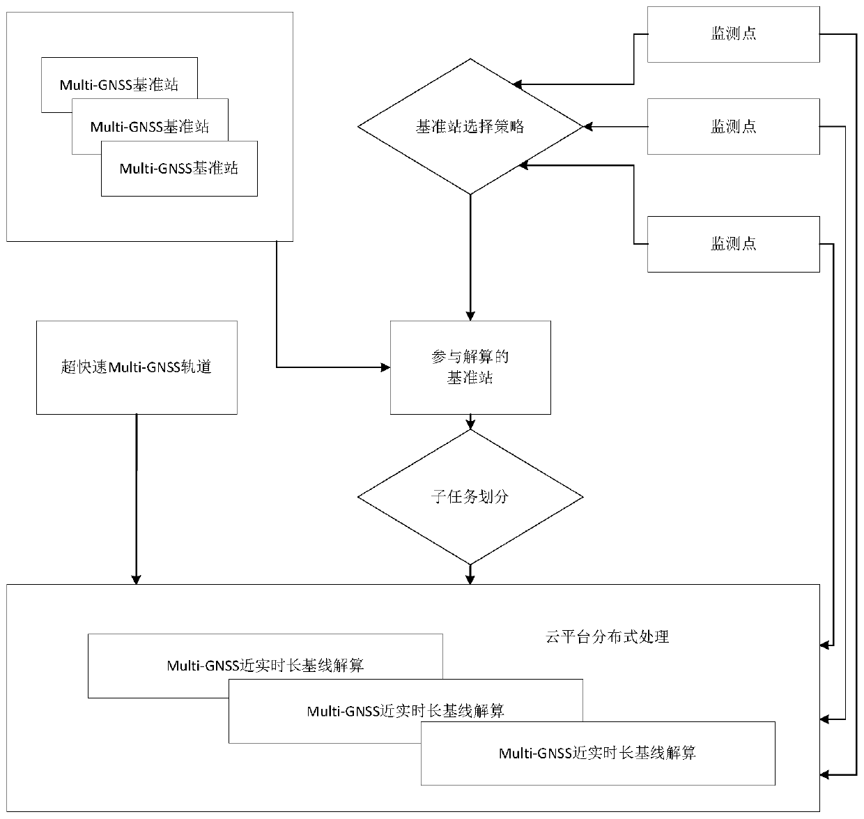
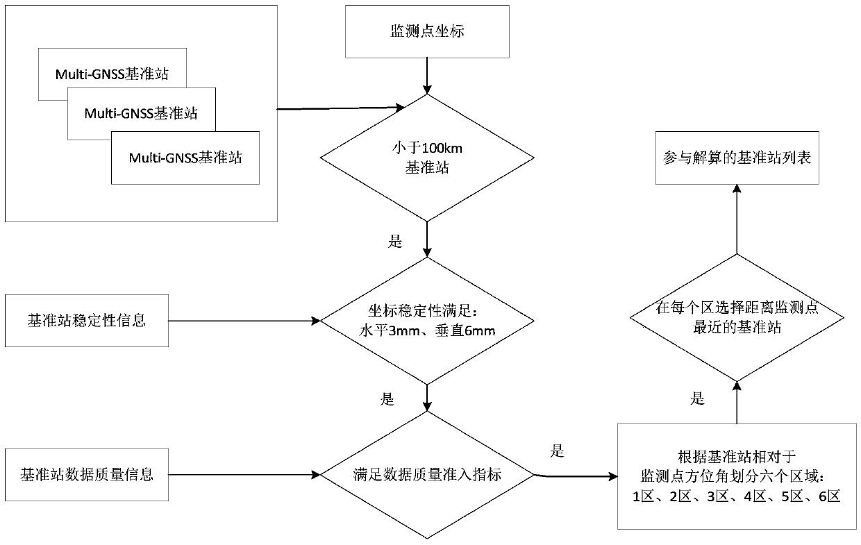
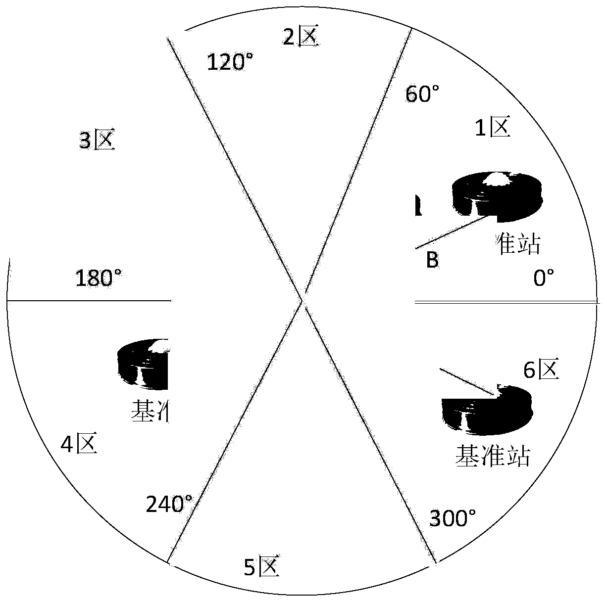
[0056] In order to improve the stability and accuracy of the long baseline solution, the present invention adopts a joint processing mode of multiple reference stations. Due to the interruption of single reference station data, periodic changes in satellite observation geometry, different stability of reference stations, different quality of reference station data, different geometric distances between reference stations and monitoring points, and different geometric distributions of reference stations relative to monitoring points, the selection of inappropriate The reference station has a great influence on the monitoring accuracy. The invention proposes a selection strategy of multiple reference stations around the monitoring point, and automatically selects reference stations participating in the calculation according to a certain threshold value, so as to preliminarily guarantee the stability and accuracy of the long baseline calculation.

[0057] In order to improve the ...


PUM


Abstract

The invention provides a multi-GNSS (Global navigation satellite system) long baseline near-real-time deformation monitoring method based on multiple base stations. In order to improve the accuracy of long baseline calculation, an ultrafast multi-GNSS satellite orbit product is used to reduce the influence of orbit error on baseline calculation. The influence of abnormal data on baseline calculation is presented as much as possible through multiple posterior residual editing iterations. Near-real-time high-precision baseline calculation can be realized through a sliding window-based batch processing mode. The precision and stability of baseline calculation can be improved through a multi-base-station joint processing mode. The precision of baseline calculation is further improved by using a creative ambiguity processing strategy. In order to improve the efficiency of data processing, a normal equation stacking technology is used and the previous normal equation information is fully utilized to avoid repeated calculation. A shared base station is used for processing, and repeated processing by the same base station is avoided. By using an un-differenced processing mode, the advantage of distributed computing can be fully utilized, and the efficiency of data processing can be improved.

Description

technical field [0001] The invention relates to the technical field of deformation monitoring, in particular to a multi-GNSS long baseline near real-time deformation monitoring method based on multiple base stations. Background technique [0002] GNSS (Global navigation satellite system, global satellite positioning system) deformation monitoring is an important technology related to the safety of people's lives and property. It has a large number of applications in dangerous building monitoring, landslide monitoring, dam monitoring and other working conditions. Traditional deformation monitoring is only carried out to solve specific businesses. With the development of the national economy, the demand for large-scale deformation monitoring services is becoming more and more obvious, such as nationwide monitoring of dilapidated buildings, landslide monitoring along long-distance railways, and settlement monitoring of long-distance power towers. [0003] GNSS deformation monit...

Claims


Application Information

Patent Timeline
Patent Type & Authority Patents(China)
IPC IPC(8): G01B7/16
Inventor 崔红正范国泽
Owner QIANXUN SPATIAL INTELLIGENCE INC
Learn More