
A Lidar-Based Early Warning Method for River Evolution

A lidar, river channel technology, applied in design optimization/simulation, electromagnetic wave re-radiation, instruments, etc., can solve the problems of inability to update survey results in real time, large investment, time-consuming and labor-intensive, etc.

Active Publication Date: 2022-03-01
四川省交通勘察设计研究院有限公司
View PDF4 Cites 0 Cited by
  • Summary
  • Abstract
  • Description
  • Claims
  • Application Information

AI Technical Summary

Problems solved by technology

[0004] The technical problem to be solved by the present invention is: how to identify the most likely location of disaster damage on an extremely long river bank, and make early warning and response, and the existing method of obtaining scour data through on-site monitoring of water sections , the investment is large, time-consuming and labor-intensive, and many places with poor terrain conditions cannot be surveyed, and the survey results cannot be updated in real time. The present invention provides a method for early warning of river channel evolution based on laser radar to solve the above problems

Method used


Image

  • A Lidar-Based Early Warning Method for River Evolution
  • A Lidar-Based Early Warning Method for River Evolution
  • A Lidar-Based Early Warning Method for River Evolution

Examples


Embodiment

[0044] How to identify the most likely location of disaster damage on the extremely long river bank, and make early warning and response; and the existing method of obtaining scour data through on-site monitoring of water sections requires a large investment, time-consuming and labor-intensive, Moreover, many places with poor terrain conditions cannot be surveyed, and the survey results cannot be updated in real time. In order to solve the above problems, this embodiment proposes a method for early warning of river channel evolution based on laser radar.

[0045] A method for early warning of river channel evolution based on lidar, comprising the following steps:

[0046]The space-borne lidar acquires the elevation data of the watershed at the i moment at the same time interval, i is a positive integer, and processes the elevation data at the i moment respectively to obtain the digital elevation model at the i moment;

[0047] Based on the digital elevation model at i time, ob...


PUM


Abstract

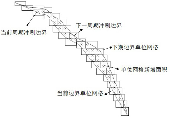
The invention discloses a laser radar-based river course evolution early warning method, which obtains scour boundary fitting curves based on space-borne laser radar, performs grid division on the scour boundary fitting curves at multiple times, and obtains n groups of corresponding grids The area increase value and area increase rate of the small area can determine the dominant direction of erosion, and give an early warning, and organize relevant personnel to conduct detailed detection of the area where the dominant direction of erosion is located through space-borne lidar. The early warning of the evolution of the river is realized, and the areas with a high probability of disaster occurrence can be obtained, and measures can be taken in time to prevent the occurrence of disasters.

Description

technical field [0001] The invention relates to the technical field of disaster early warning along river highways, in particular to a laser radar-based early warning method for river course evolution. Background technique [0002] In my country, there are more than 250,000 KM long project slopes and embankments facing the problem of slope stability caused by watershed erosion. Due to the erosion, transportation and accumulation of the river, the erosion of the river will cause side erosion and down erosion of the river bed, river siltation, etc., resulting in serious consequences such as bank slope damage, disaster destruction and incidental secondary disasters. Discrimination of the most likely location of disaster damage on this extremely long river bank and rapid identification and response of the size of the damage are all problems that need to be solved urgently. [0003] As far as the watershed scour records are concerned, it mainly relies on on-the-spot monitoring o...

Claims


Application Information

Patent Timeline
Patent Type & Authority Patents(China)
IPC IPC(8): G06F30/20G01S17/88G01C5/00
CPCG06F30/20G01S17/88G01C5/00
Inventor 袁松张庆陈柯竹宋松科权新蕊姚萌郑国强
Owner 四川省交通勘察设计研究院有限公司
Learn More