Eureka AIR delivers breakthrough ideas for toughest innovation challenges, trusted by R&D personnel around the world.

Portable engineering surveying and mapping device for geological mineral exploration

A surveying and mapping device and portable technology, applied in the directions of surveying device, surveying and navigation, surveying instrument, etc., can solve the problems of inconvenient long-distance carrying, large size, complicated operation, etc., and achieve the effect of improving convenience

Pending Publication Date: 2022-01-28
山东省地质矿产勘查开发局第七地质大队
View PDF9 Cites 0 Cited by
  • Summary
  • Abstract
  • Description
  • Claims
  • Application Information

AI Technical Summary

Problems solved by technology

[0003] At present, most of the commonly used geological and mineral surveying and mapping equipment are portable total stations, which are not only convenient to deploy, but also simple to install and high in construction efficiency. Repeated leveling is required for use on rough and uneven terrain, and the operation is cumbersome

Method used


Image

  • Portable engineering surveying and mapping device for geological mineral exploration
  • Portable engineering surveying and mapping device for geological mineral exploration
  • Portable engineering surveying and mapping device for geological mineral exploration

Examples


Embodiment Construction

[0039] The specific implementation of the present invention will be described in detail below in conjunction with specific embodiments.

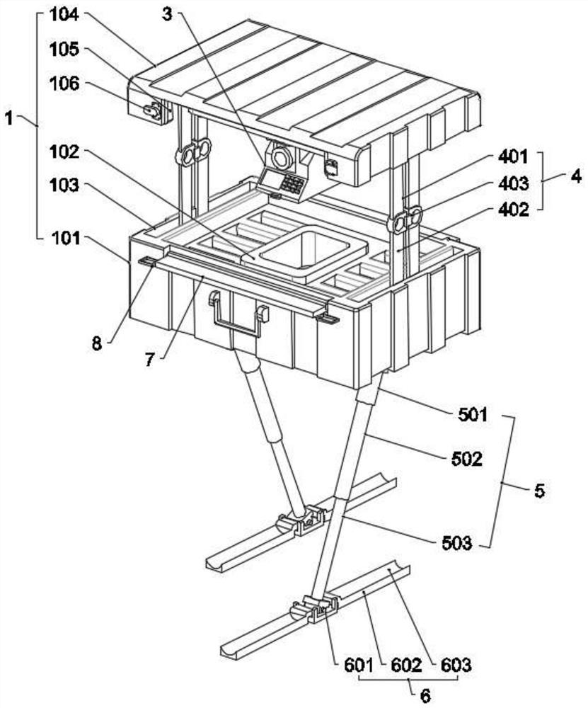
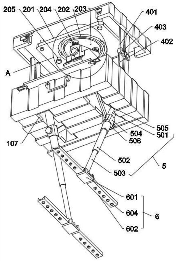
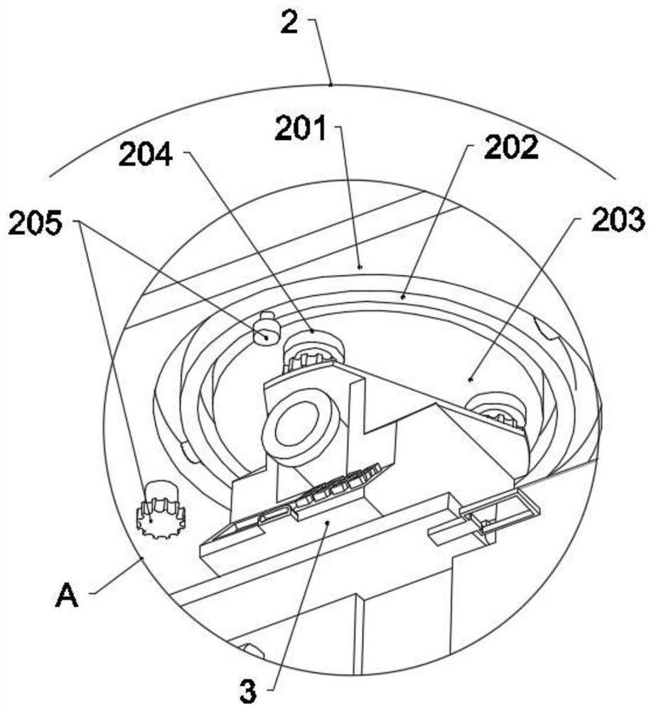
[0040] see Figure 1-Figure 5 , a portable engineering surveying device for geological and mineral exploration in an embodiment of the present invention includes a housing member 1, and the housing member 1 includes a base housing 101 and a mobile housing 104, and the base housing 101 is arranged with The storage tank 102 is used to place and store the surveying and mapping equipment 3; the leveling assembly 2 is fixedly arranged on one side of the mobile housing 104, and is set toward the side of the base housing 101, and is used for assembling and connecting the surveying and mapping equipment 3, so that all The above-mentioned surveying and mapping equipment 3 tends to a horizontal state under the action of gravity; the connecting frame assembly 4, a number of connecting frame assemblies 4 are arranged between the base housing 101 and the...


PUM


Abstract

The invention discloses a portable engineering surveying and mapping device for geological mineral exploration, and belongs to the technical field of surveying and mapping equipment. The portable engineering surveying and mapping device comprises a shell component comprising a base shell and a movable shell; a storage tank for placing surveying and mapping equipment is arranged in the base shell; a leveling assembly is fixedly arranged on one side of the movable shell and used for assembling and connecting the surveying and mapping equipment, the surveying and mapping equipment can automatically tend to be in a horizontal state under the action of gravity; and a plurality of connecting frame assemblies are arranged between the base shell and the movable shell and used for connecting and supporting the base shell and the movable shell. The portable engineering surveying and mapping device further comprises a supporting leg mechanism used for bearing the base shell in a surveying and mapping process. According to the portable engineering surveying and mapping device, the detachable shell component and the engineering surveying and mapping equipment which is suspended in the shell component through the leveling assembly are adopted, the engineering surveying and mapping equipment can be quickly disassembled and assembled, meanwhile, the surveying and mapping equipment can be matched with the leveling assembly so as to be adaptively leveled, so that the engineering surveying and mapping equipment adapts to various rugged terrains to work, and the use convenience is improved.

Description

technical field [0001] The invention belongs to the field of surveying and mapping equipment, in particular to a portable engineering surveying and mapping device for geological and mineral resources surveying. Background technique [0002] Engineering surveying is topographic surveying, construction lofting and deformation monitoring carried out in various stages of engineering construction and natural resource development. In engineering surveying, whether it is systematic engineering surveying, highway surveying or geological and mineral surveying, etc., it is necessary to use surveying technology. It plays an important role in the planning and design stage of engineering projects. Through the application of engineering measurement technology, in-depth investigation and research on the surface, underground, water body and air environment conditions around the project and the project can effectively help engineering design and management personnel to master the project. Th...

Claims


Application Information

Patent Timeline
Patent Type & Authority Applications(China)
IPC IPC(8): F16M11/04F16M11/18F16M11/26G01C15/00
CPCF16M11/046F16M11/18F16M11/26G01C15/00F16M2200/08F16M2200/066
Inventor 李新凤冯爱平刘传朋
Owner 山东省地质矿产勘查开发局第七地质大队
Why Eureka
Eureka Blog
Learn More