GIS spatio-temporal data model for underground illegal mining identification

A technology of spatio-temporal data and models, applied in geographic information databases, data processing applications, structured data retrieval, etc., can solve problems such as inability to accurately reflect geological phenomena and dynamic processes, and difficulty in supporting dynamic digital expression of underground mining spatio-temporal processes. Achieve the effect of avoiding excessive exploitation of resources, strong practicability, and avoiding real-time monitoring

Pending Publication Date: 2022-01-28
EAST CHINA UNIV OF TECH
View PDF0 Cites 0 Cited by
  • Summary
  • Abstract
  • Description
  • Claims
  • Application Information

AI Technical Summary

Problems solved by technology

[0004] Therefore, in the process of underground mining in mines, accurate simulation and description of the spatio-temporal change process of mining subsidence can effectively provide a platform guarantee for the identification and monitoring of different types of illegal mining events in the later stage, and reduce economic losses and losses caused by illegal underground mining in mines. Casualties, and the mine model constructed by the traditional mine information system is difficult to support the dynamic digital expression of the space-time process of underground mining, and cannot accurately reflect the geological phenomena and dynamic processes induced by the underground mining of the mine

Method used


Image

  • GIS spatio-temporal data model for underground illegal mining identification
  • GIS spatio-temporal data model for underground illegal mining identification
  • GIS spatio-temporal data model for underground illegal mining identification

Examples


Embodiment Construction

[0050] In order to enable those skilled in the art to better understand the technical solution of the present invention, the technical solution of the present invention will be further described below in conjunction with the accompanying drawings and embodiments.

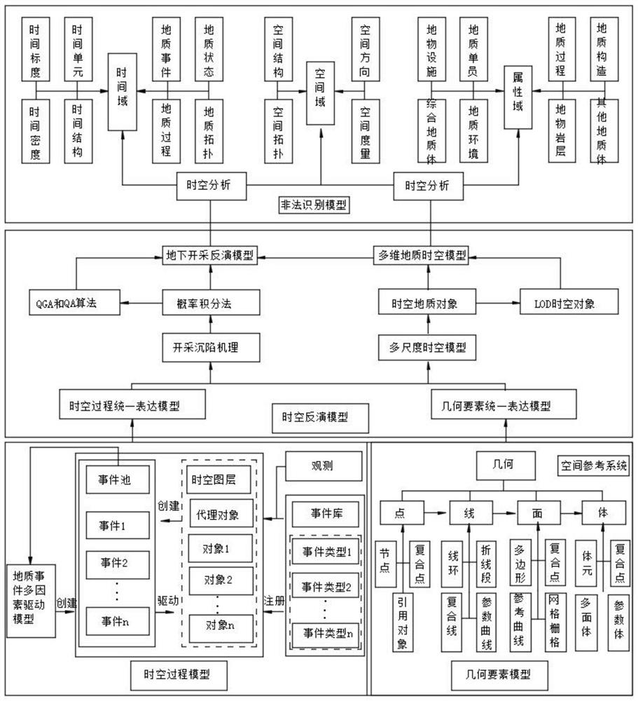
[0051] Refer to attached Figure 1-4 A GIS spatio-temporal data model oriented to identification of underground illegal mining is shown, including geometric element model layer, spatio-temporal process model layer, spatio-temporal inversion model layer and illegal identification model layer;

[0052] 1. Geometric element model layer: The geometric element model layer is the most basic part of spatial data integration and extended modeling. It can abstract the entire geological geometric space into points and lines according to the geometric elements expression requirements of above-ground and underground, indoor and outdoor models. Four kinds of spatial entity objects, surface and volume, not only geometrically expr...


PUM


Abstract

The invention discloses a GIS spatio-temporal data model for underground illegal mining identification. The GIS spatio-temporal data model comprises a geometric element model layer, a spatio-temporal process model layer, a spatio-temporal inversion model layer and an illegal identification model layer.The four model hierarchies are mutually associated and interacted, expression of spatio-temporal processes of mine geological objects such as ore bodies, roadways, rock masses, mining right ranges, underground mining faces and goaf under the multi-time granularity and multi-space scale, fusion of multi-level and multi-source earth observation data and response of multi-level illegal mining events can be comprehensively supported. The GIS spatio-temporal data model for underground illegal mining identification is established by combining actual requirements of real-time monitoring of underground illegal mining and simulating and describing a mining subsidence spatio-temporal change process on the basis of analyzing and expressing mining subsidence spatio-temporal change, and a platform guarantee is provided for subsequent identification and monitoring of different types of illegal mining events.

Description

technical field [0001] The invention relates to the technical field of illegal mining identification, in particular to a GIS spatio-temporal data model for underground illegal mining identification. Background technique [0002] In the process of underground mining, with the continuous advancement of the underground mining face, geological objects such as mine rock formations, ore bodies, and ground surfaces will be affected to a certain extent to cause displacement and deformation, and even change their inherent attribute information, and The dynamic process of underground mining in mines has the characteristics of multi-source, multi-dimensional and multi-granularity spatio-temporal changes. When underground mining reaches a certain level, it will cause mining subsidence and surface deformation; [0003] During the process of space movement, mining subsidence is continuously advanced by the underground working face, causing deformation of the surrounding rock of the mine, ...

Claims


Application Information

Patent Timeline
IPC IPC(8): G06F16/29G06Q50/02
CPCG06F16/29G06Q50/02
Inventor 夏元平惠振阳侯靖钥胡子阳
Owner EAST CHINA UNIV OF TECH
Why Eureka
Try Eureka