
Vehicle path planning method based on hierarchical monitoring domain and adaptive artificial potential field method

An artificial potential field method and vehicle routing technology, applied in the field of unmanned vehicle path planning, can solve problems such as inability to generate feasible paths, and achieve the effects of improving various performance indicators, improving safety, and optimizing computing efficiency

Pending Publication Date: 2022-02-15
TIANJIN CHENGJIAN UNIV +1
View PDF0 Cites 0 Cited by
  • Summary
  • Abstract
  • Description
  • Claims
  • Application Information

AI Technical Summary

Problems solved by technology

Due to the current research on the artificial potential field method ignoring the consideration of the environment, unmanned vehicles cannot generate feasible paths in dynamic or unknown environments.

Method used


Image

  • Vehicle path planning method based on hierarchical monitoring domain and adaptive artificial potential field method
  • Vehicle path planning method based on hierarchical monitoring domain and adaptive artificial potential field method
  • Vehicle path planning method based on hierarchical monitoring domain and adaptive artificial potential field method

Examples


Embodiment Construction

[0061] In order to enable those skilled in the art to better understand the technical solution of the present invention, the present invention will be described in detail below in conjunction with the accompanying drawings and specific embodiments.

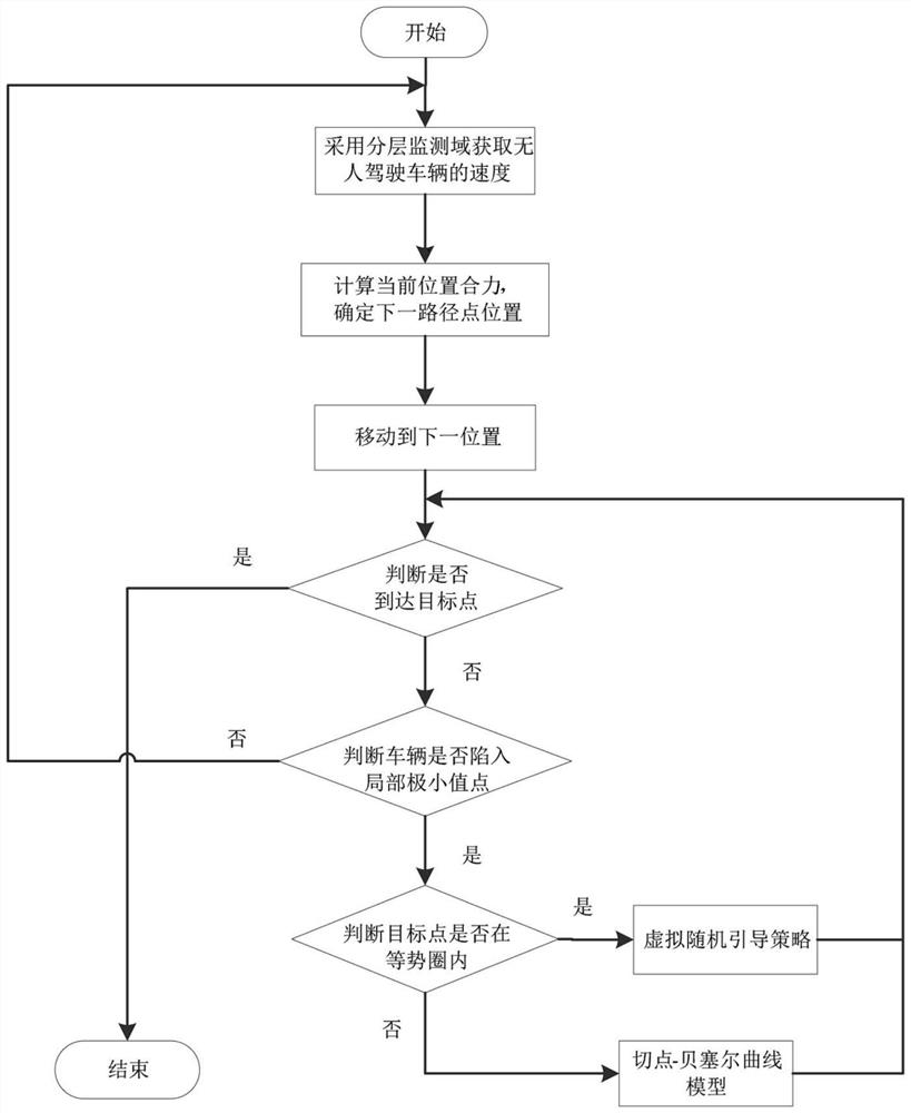
[0062] Embodiments of the present invention provide a vehicle path planning method based on hierarchical monitoring domains and adaptive artificial potential field method, such as figure 1 shown, including the following steps:

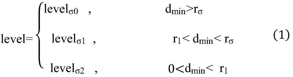
[0063] Step 1: Use the hierarchical monitoring domain model to obtain the speed of the unmanned vehicle: set the dynamic monitoring domain of the unmanned vehicle, and calculate the current driving speed of the unmanned vehicle according to the position of the obstacle in the dynamic monitoring domain; The layer monitoring domain model sets different warning levels for environmental changes to realize self-adaptive changes in the speed of unmanned vehicles.

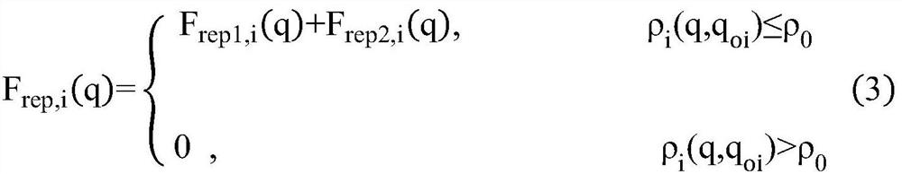
[0064] The specific process of using the hiera...


PUM


Abstract

The invention provides a vehicle path planning method based on a hierarchical monitoring domain and an adaptive artificial potential field method. The method comprises the following steps: acquiring the speed of an unmanned vehicle by using a hierarchical monitoring domain model; calculating resultant force borne by the unmanned vehicle; calculating the position of the next path point; then enabling the unmanned vehicle to move to the next position; judging whether the unmanned vehicle arrives at a target point or not; if the unmanned vehicle does not arrive at the target point, judging whether the unmanned vehicle falls into a local minimum value point or not; and adopting a tangent point-Bezier curve model to guide the unmanned vehicle to get rid of a local minimum value point or oscillation point area, or adopting a virtual random guide strategy to guide the vehicle to get rid of the local minimum value point or oscillation point area. According to the method, the speed of the unmanned vehicle is controlled by using the hierarchical monitoring domain model, the unmanned vehicle is guided to get rid of the local minimum value point or oscillation point area by using the tangent point-Bezier curve model and the virtual random guide strategy, and the method is suitable for a complex space environment.

Description

technical field [0001] The invention belongs to the field of unmanned vehicle path planning, in particular to a vehicle path planning method based on layered monitoring domains and an adaptive artificial potential field method. Background technique [0002] In recent years, unmanned vehicles have been widely used in civilian and military fields, and have undertaken important tasks such as intelligent transportation, emergency rescue, and military operations. Path planning is the core technology for the intelligence and autonomy of unmanned vehicles. It is mainly under the constraints of dynamic conditions and complex environments, unmanned vehicles find a collision-free optimal or suboptimal path from the current position to the target position in real time. In essence, path planning technology is a method of optimizing complex systems. However, the current path planning technology still has problems such as insufficient autonomous obstacle avoidance ability and poor adapt...

Claims


Application Information

Patent Timeline
IPC IPC(8): G01C21/20G01C21/34
CPCG01C21/20G01C21/3446
Inventor 潘玉恒陶艺鑫鲁维佳孟卓王丽
Owner TIANJIN CHENGJIAN UNIV
Features
  • Generate Ideas
  • Intellectual Property
  • Life Sciences
  • Materials
  • Tech Scout
  • Unparalleled Data Quality
  • Higher Quality Content
  • 60% Fewer Hallucinations
Learn More