Curve vehicle relative position classification method based on cooperative vehicle infrastructure system

A vehicle-road coordination and relative position technology, applied in the direction of road vehicle traffic control system, traffic control system, traffic flow detection, etc., can solve the problem of inaccurate judgment of the relative position of the surrounding vehicles, and achieve the judgment of the relative position of the vehicle. Effect

Active Publication Date: 2022-03-15
CATARC TIANJIN AUTOMOTIVE ENG RES INST CO LTD +1
View PDF4 Cites 2 Cited by
  • Summary
  • Abstract
  • Description
  • Claims
  • Application Information

AI Technical Summary

Problems solved by technology

[0004] In view of this, the present invention aims to propose a method for classifying the relative positions of vehicles on curves based on the vehicle-road coordination system, so as to solve the problem of inaccurate judgment of the relative positions of surrounding vehicles due to the influence of obstacles or weather when vehicles are traveling on curves. The problem

Method used


Image

  • Curve vehicle relative position classification method based on cooperative vehicle infrastructure system
  • Curve vehicle relative position classification method based on cooperative vehicle infrastructure system
  • Curve vehicle relative position classification method based on cooperative vehicle infrastructure system

Examples


Embodiment

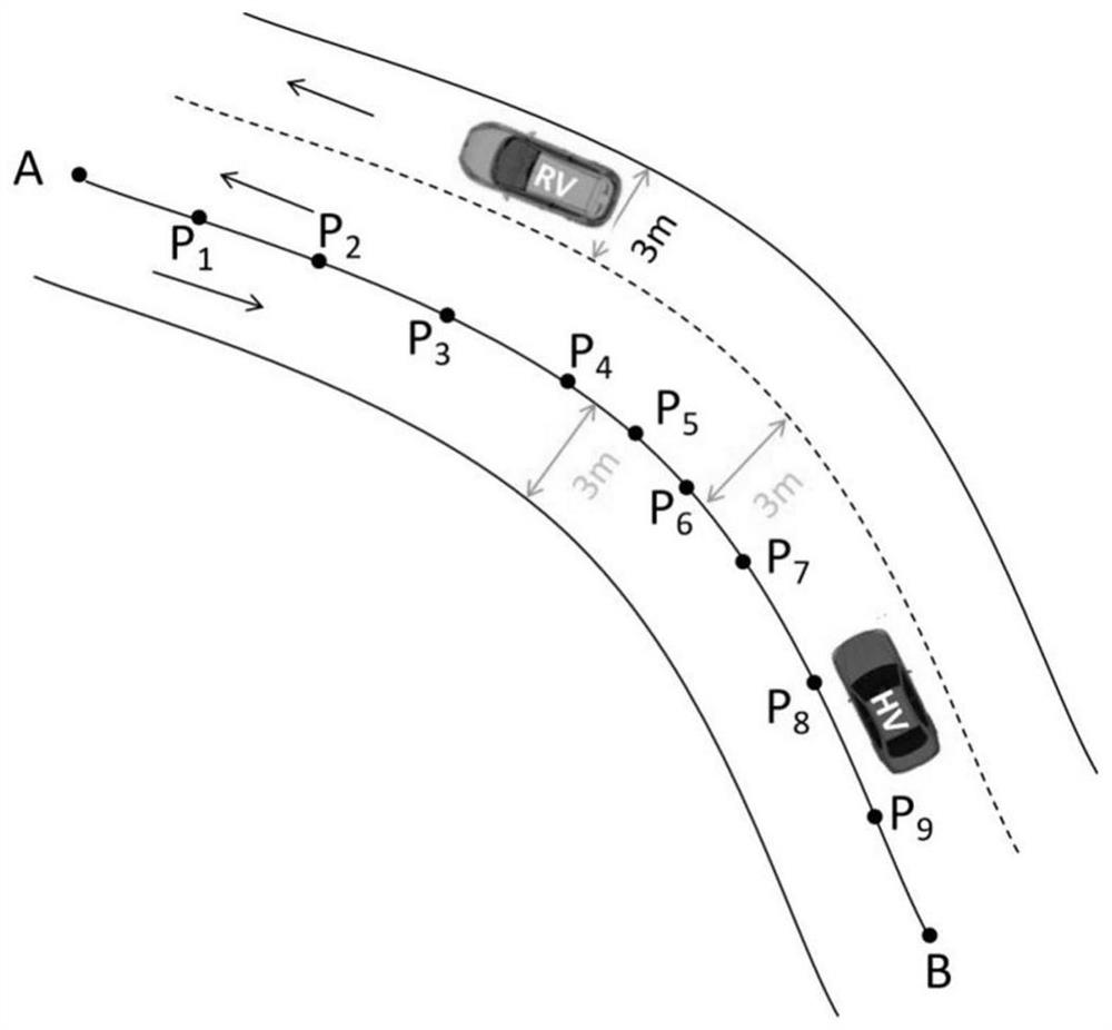
[0079] In this embodiment, a method for classifying the relative position of curved vehicles based on the vehicle-road coordination system is based on figure 1 on the road shown. The roads driven by HV and RV contain a road section AB, in which there are 9 reference position points because the road section is a road with a certain curvature: P 1 (X 1 ,Y 1 ), P 2 (X 2 ,Y 2 )...P 9 (X 9 ,Y 9 ) to indicate that road section AB is subdivided into three lanes, which are defined as lane1, lane2 and lane3 from left to right, and the width of each lane is 3m. The current driving position of the HV is P H (X H , Y H ), the driving speed is V H , the heading angle is θ H , the current driving position of the RV is P R (X R , Y R ), the driving speed is V R , the heading angle is θ R .

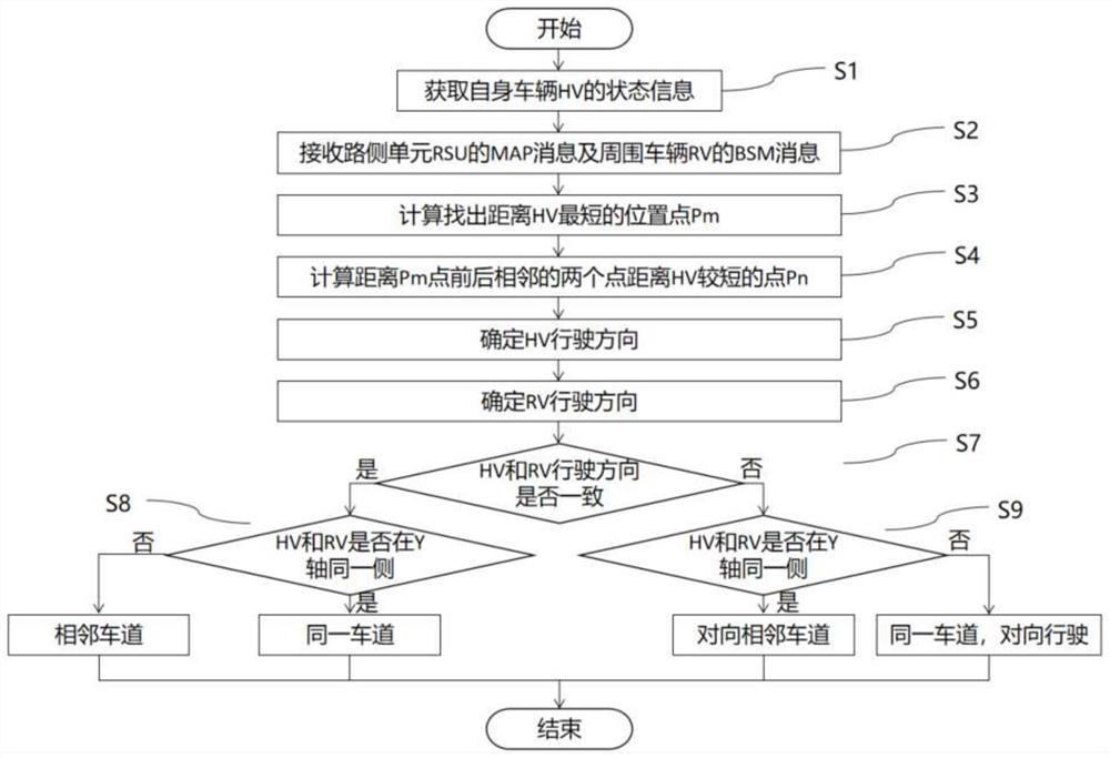
[0080] Such as figure 2 As shown, a flow chart of a method for classifying the relative position of curved vehicles based on the vehicle-road coordination system, the specific steps ...


PUM


Abstract

The invention provides a curve vehicle relative position classification method based on a vehicle-road cooperation system. The method comprises the following steps: obtaining messages of a vehicle HV, a road side unit and surrounding vehicles; judging the driving direction of the HV and the driving direction of the RV according to the information; judging whether the HV and the RV are on the same coaxial side of the coordinate system or not according to the coordinate system, and judging whether the two vehicles are on the same lane or adjacent lanes or not; and judging the driving directions of the HV and the RV according to whether the two vehicles are on the opposite adjacent lanes. The invention discloses a curve vehicle relative position classification method based on a vehicle-road cooperation system, which is used for judging the relative position of a vehicle in a curve based on the vehicle-road cooperation system, and solves the problem of judging the relative position of the vehicle under the conditions of shelters and weather in the prior art.

Description

technical field [0001] The invention belongs to the technical field of vehicle-road coordination, and in particular relates to a method for classifying relative positions of vehicles on a curved road based on a vehicle-road coordination system. Background technique [0002] The vehicle-road coordination system realizes real-time dynamic information interaction between vehicles, roads and pedestrians through the Internet of Vehicles technology, thereby improving travel safety. The Internet of Vehicles technology mainly relies on the Road Side Unit (Road Side Unit, RSU) and the On Board Unit (OBU) installed at the road end for communication. The existing collision judgment between vehicles in the curve mainly relies on sensors such as radar or camera, but the radar only detects a section of the area directly in front of it, which has certain limitations for the detection in the curve, and the camera's Detection is vulnerable to weather. [0003] Therefore, in combination wit...

Claims


Application Information

Patent Timeline
Patent Type & Authority Applications(China)
IPC IPC(8): G08G1/01G08G1/056
CPCG08G1/0112G08G1/0116G08G1/056Y02T10/40
Inventor 吴志新郭蓬王梦丹杨建森蔡聪许扬眉张登权夏海鹏
Owner CATARC TIANJIN AUTOMOTIVE ENG RES INST CO LTD
Why Eureka
Try Eureka