Optical satellite remote sensing image detection method

A remote sensing image and optical satellite technology, applied in the field of remote sensing, can solve the problems of long processing time of remote sensing satellite image data, untimely remote sensing data processing, and processing efficiency to be further improved, and achieve the effect of improving processing efficiency.

Active Publication Date: 2022-04-12
西安中科西光航天科技有限公司
View PDF9 Cites 1 Cited by
  • Summary
  • Abstract
  • Description
  • Claims
  • Application Information

AI Technical Summary

Problems solved by technology

[0004] The invention provides an optical satellite remote sensing image detection method to solve the problems that the existing method takes too long to...

Method used


Image

  • Optical satellite remote sensing image detection method
  • Optical satellite remote sensing image detection method

Examples


Embodiment Construction

[0022] In order to make the purpose, technical solution and advantages of the present invention clearer, the technical solution of the present invention will be clearly and completely described below in conjunction with specific embodiments of the present invention and corresponding drawings. Apparently, the described embodiments are only some of the embodiments of the present invention, but not all of them. Based on the embodiments of the present invention, all other embodiments obtained by persons of ordinary skill in the art without making creative efforts belong to the protection scope of the present invention. The technical solutions provided by various embodiments of the present invention will be described in detail below in conjunction with the accompanying drawings.

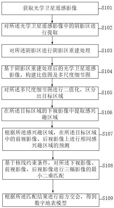
[0023] see figure 1 , the present invention provides an optical satellite remote sensing image detection method, comprising:

[0024] Step S101, acquiring optical satellite remote sensing images.

[00...


PUM


Abstract

The invention discloses an optical satellite remote sensing image detection method. The invention provides an optical satellite remote sensing image detection method, and the method comprises the steps: obtaining an optical satellite remote sensing image, extracting a shadow region in the optical satellite remote sensing image, carrying out the shadow region reconstruction processing of the shadow region, and constructing a ratio graph and a multi-scale detail graph based on the optical satellite remote sensing image after the shadow region reconstruction processing. Performing binaryzation on the multi-scale detail image, distinguishing a target area, extracting an area of interest from a downward-looking image of the target area, performing prediction of the same area of interest on a forward-looking image and a backward-looking image in the target area according to the area of interest, and performing prediction of the same area of interest on the basis of epipolar constraint conditions. And performing least square matching on the downward-looking image, the forward-looking image and the rear-looking image, and performing forward intersection according to a matching result to obtain a digital earth surface model, so that the processing efficiency of remote sensing satellite image data is further improved.

Description

technical field [0001] The invention relates to the technical field of remote sensing, in particular to an optical satellite remote sensing image detection method. Background technique [0002] Remote sensing image (abbreviation: RS, English: Remote Sensing Image) refers to the film or photo that records the electromagnetic wave size of various ground features, mainly divided into aerial photos and satellite photos. With the rapid development of optical satellite remote sensing images, this technology plays an extremely important role in military applications such as homeland defense and regional reconnaissance, as well as civilian fields such as disaster monitoring, emergency relief, and disaster prevention and early warning. [0003] The Chinese patent with application number 202110879945.5 discloses a processing method for remote sensing satellite image data, which includes the following steps: S1. Use source coding to assign independent data identifiers to remote sensing...

Claims


Application Information

Patent Timeline
IPC IPC(8): G06T7/00G06V20/13G06V10/25G06V10/28G06V10/48G06V10/764G06K9/62
Inventor 秦静祝青
Owner 西安中科西光航天科技有限公司
Why Eureka
Try Eureka