
Unmanned aerial vehicle topographic surveying and mapping device with self-stabilizing holder

A technology of terrain surveying and unmanned aerial vehicles, which is applied in the direction of unmanned aircraft, motor vehicles, aircraft parts, etc., can solve the problems that the functionality needs to be improved, there is no anti-accident structure, and the protection of surveying and mapping devices cannot be provided, so as to improve the automatic Protective performance, the effect of improving the anti-fall performance

Inactive Publication Date: 2022-05-10
宋如飞 +4
View PDF0 Cites 0 Cited by
  • Summary
  • Abstract
  • Description
  • Claims
  • Application Information

AI Technical Summary

Problems solved by technology

[0004] The object of the present invention is to provide a UAV topographic surveying device with a self-stabilizing platform to solve the above-mentioned background technology. Factors, unable to effectively provide protection in the event of an accident in the surveying and mapping device, and the functionality needs to be improved

Method used


Image

  • Unmanned aerial vehicle topographic surveying and mapping device with self-stabilizing holder
  • Unmanned aerial vehicle topographic surveying and mapping device with self-stabilizing holder
  • Unmanned aerial vehicle topographic surveying and mapping device with self-stabilizing holder

Examples


Embodiment 1

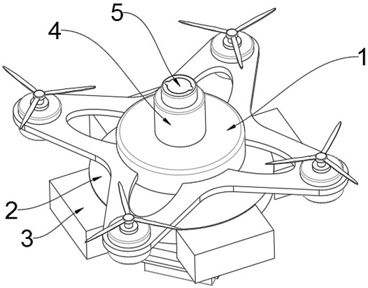
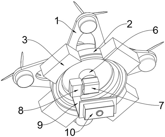
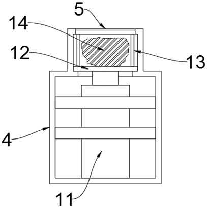
[0030] see Figure 1-5 , an embodiment provided by the present invention: a UAV terrain surveying device with a self-stabilizing platform, including a UAV 1, a first casing 2 is fixedly connected to the side surface of the UAV 1, and the first casing 2 is provided with a storage groove 16 on the lower end surface, and the inside of the storage groove 16 is provided with a protective rubber airbag 17. The protective rubber airbag 17 communicates with the inside of the first housing 2, and the side surface of the first housing 2 is fixedly connected with a plurality of The second housing 3, the second housing 3 communicates with the inside of the first housing 2, the inside of the second housing 3 is provided with a second electromagnet 15 and solid sodium azide 20, the inner middle of the second housing 3 The position is fixedly connected with a fixed mounting plate 19, and the middle position of the outer surface of the fixed mounting plate 19 is provided with a mounting hole,...

Embodiment 2

[0035] like Figure 6-9 Shown, a kind of unmanned aerial vehicle topography surveying device with self-stabilizing cloud platform is different from embodiment 1, and self-stabilizing platform comprises the fixed connecting seat that is arranged at the middle position below the unmanned aerial vehicle, and fixed connecting seat 6 The lower end is connected to the topographic surveying and mapping module 10 through the suspension rod 25. Specifically, the fixed seat is connected with a connecting plate 21, and the connecting plate 21 and the topographic mapping module 10 are all connected with the suspension rod 25 through the rotating seat 32. The suspension rod is made of stainless steel It is made of pipe and has good bending strength. Both ends of the suspension rod 25 are coaxially fixed with a ball head 26. There is a groove in the rotating seat 32 that matches the ball head 26. The opening of the groove is installed with a Gland 29, the gland 29 is processed with a lubric...


PUM


Abstract

The invention discloses an unmanned aerial vehicle topographic surveying and mapping device with a self-stabilizing holder, relates to the technical field of unmanned aerial vehicle topographic surveying and mapping, and aims to solve the problems that an existing unmanned aerial vehicle topographic surveying and mapping device is not provided with an accident prevention structure, many uncertain factors exist in field topographic surveying and mapping, and protection cannot be effectively provided when an accident occurs in the surveying and mapping device. And functionality needs to be improved. A first shell is fixedly connected to the side surface of the unmanned aerial vehicle, a storage groove is formed in the lower end face of the first shell, a protective rubber air bag is arranged in the storage groove and communicates with the interior of the first shell, and a plurality of second shells are fixedly connected to the side surface of the first shell. And the second shell communicates with the interior of the first shell, a second electromagnetic device and solid sodium azide are arranged in the second shell, and a third shell is fixedly installed in the middle of the upper surface of the unmanned aerial vehicle.

Description

technical field [0001] The invention relates to the technical field of unmanned aerial vehicle terrain surveying and mapping, in particular to an unmanned aerial vehicle terrain surveying and mapping device with a self-stabilizing platform. Background technique [0002] Topographic surveying refers to the operation of surveying and drawing topographic maps, that is, to measure the projected position and elevation of the ground objects and topography on the horizontal plane on the earth's surface, and reduce them according to a certain proportion, and draw them into topographic maps with symbols and notes. With the development of science and technology, the application of drones has greatly reduced the difficulty of terrain surveying and mapping. [0003] The existing UAV terrain surveying and mapping devices have no accident-proof structure. In the field terrain surveying and mapping, there are many uncertain factors, which cannot effectively provide protection when accident...

Claims


Application Information

Patent Timeline
Patent Type & Authority Applications(China)
IPC IPC(8): B64D45/04B64D17/80B64D17/62B64D47/08B64C39/02
CPCB64D45/04B64D17/80B64D17/62B64D47/08B64C39/02B64U2101/30B64U70/83
Inventor 宋如飞刘博张鹏张元胡鑫
Owner 宋如飞
Learn More